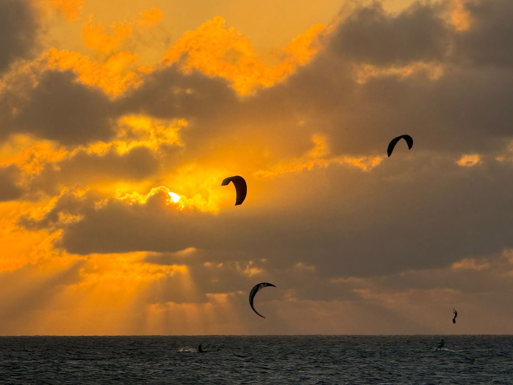
Good morning Bay Islands. Our photo of the day comes from Jim Goodwyn in Camp Bay. At first I thought these were birds, but they are actually the paragliders you often see on the Camp Bay side, which is perfectly situated to catch the easterly winds but has a little less wave action, being on the north side. We will continue to have moderate 15 mph winds and seas 2-3 feet until midweek, when winds calm a bit.
We are mostly clear this morning, with some hazy clouds over Utila. We will be sunny and dry today, but starting tomorrow we will have small rain chances, especially in the morning. Tomorrow the chance is 10 percent, but it moves up to 20 percent Tuesday and 30 percent Wednesday and Thursday.
Great news! we have a the updated English price list for the best meats on the island at Carniceria Rosita!
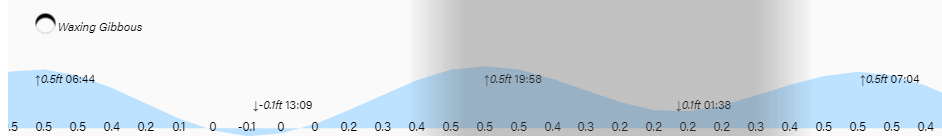
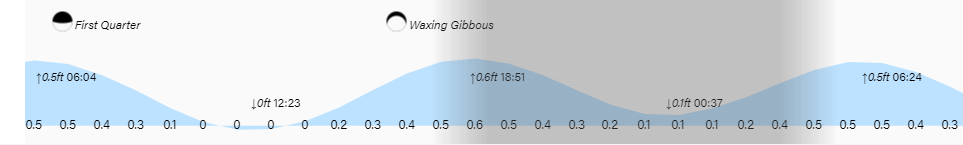
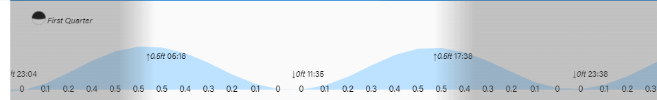
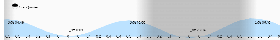
Low tides are 1 p.m. and 1:30 a.m. Have a great Sunday!
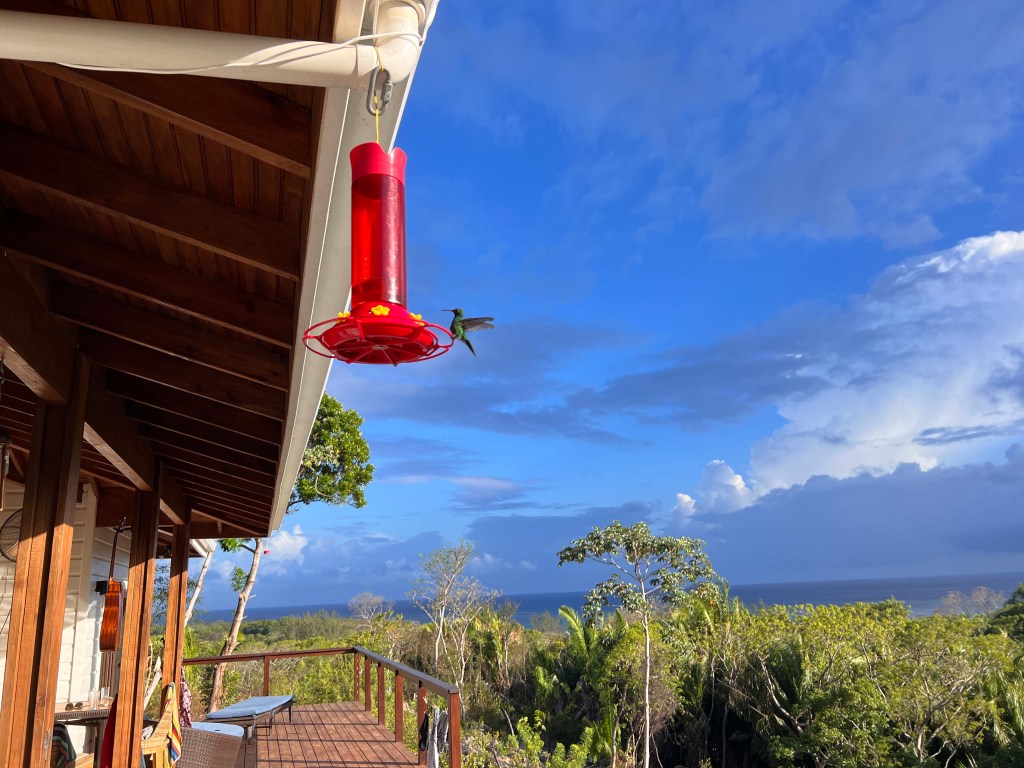
Good morning Bay Islands. Our photo of the day comes from Tom DeMille in Palmetto Bay and shows one of our favorite island residents, the hummingbird, with a nice cumulus cloud in the background. We have a few of those cumulus clouds around this morning.
Speaking of Palmetto Bay, they along with other midisland residents got a small shower this morning around 3:30 a.m.
At 7:30 a.m. there are a few popcorn clouds around, especially on the east side. I got a little sprinkle here on Jonesville Point, but not enough to amount to anything. We will continue with a small chance of a shower this morning, but otherwise we will be mostly sunny with winds from the east at 15 mph. We will remain mostly dry this weekend, but as we get into next week, especially the middle of the week, we will have a better chance of morning showers, perhaps a 30 percent chance each morning.
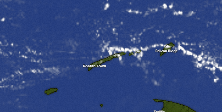
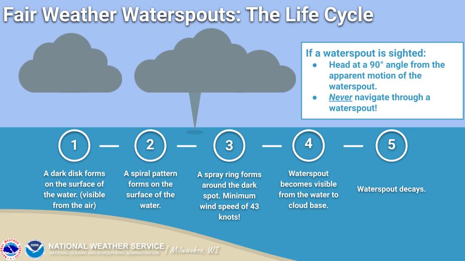
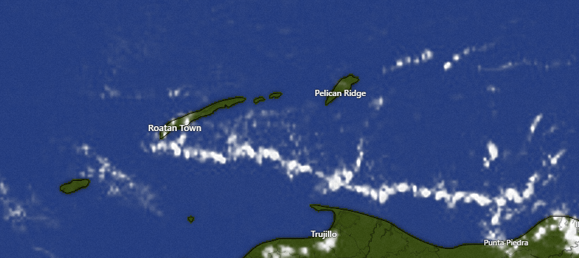
Good morning Bay Islands. Our photo of the day comes from Christina Matthews and west taken from Iron Shore on West Bay. It is a waterspout, a fairly common occurrence in our tropical waters, so I thought in comments I would talk a little about what a waterspout is and is not.
There are two types of water spouts: tornadic and fair-weather. We do not have tornadic water spouts for the simple reason that we do not have tornadoes at all this close to the equator. They typically form along the dark, flat bases of a line of developing cumulus clouds (what I like to call popcorn clouds). They develop when the air at the base of the cumulus cloud is much cooler than the temperature of the surface waters, causing an updraft. They generally don’t move very much, so they are easy for boaters to avoid, and they last an average of 5 to 10 minutes. So click a picture fast, because it won’t last long.
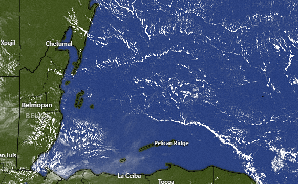
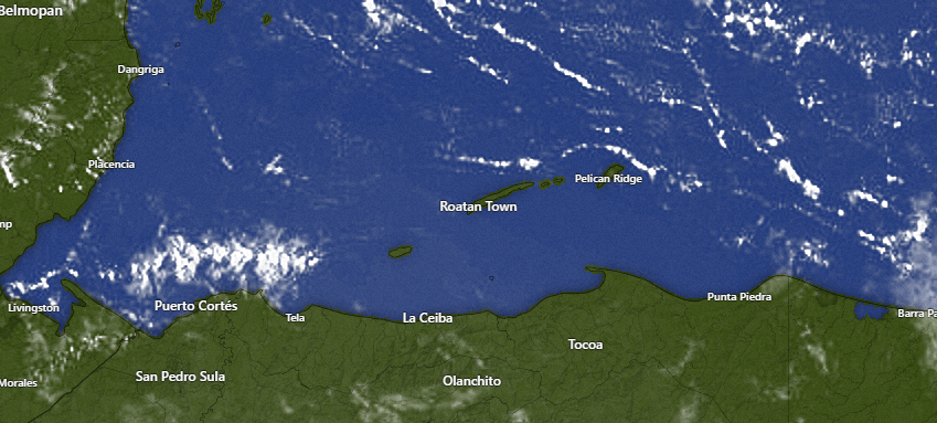
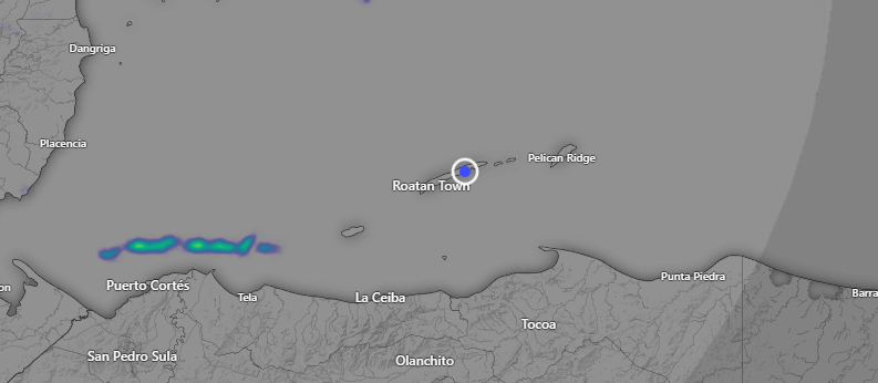
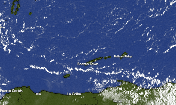
On satellite this morning we see some cumulus clouds north of Puerto Cortes, and who knows? Maybe they are seeing a water spout over there. These are the kind of clouds that produce them and also some small morning showers.
Here is the radar at 7 a.m. showing a line of showers north of Puerto Cortes. Unfortunately these are moving to the west away from us. We will stay high and dry. Each morning we have maybe a 5 percent chance of a shower, but Monday through Wednesday morning next week looks to be a little higher, maybe 20 percent chance of a small morning shower.
Wind and Galaxy Wave forecast: Our east winds will remain consistent, at 15 mph from the east with 2-3 foot seas daytime and 20 mph from the east and 3 foot seas nighttime. Just a quick reminder that you still have time to take advantage of the 25 percent discount on trips on the Galaxy Wave to La Ceiba. Tickets can be bought this month for future trips!
Low tides are 12:30 p.m. and 12:30 a.m. Have a great Friday!
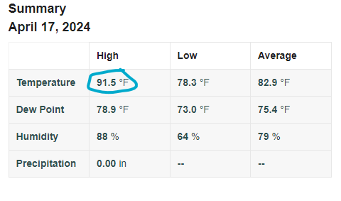
I get occasional questions about the temperature forecast. I generally don’t do a temp forecast because the temperature is generally the same, with the exception of a few days each year where we have northers. But one thing that has an impact on how hot it is where you are, is whether you are on the sea getting a sea breeze or if you are inland. Let’s take a look at the only weather station I can find that’s a bit inland. It’s call West Bay Hills, on the road between West Bay and West End (if this is your station, please send me a message so I can have your contact info). Let’s see how its temps for yesterday’s high compared to a nearby station on the sea.
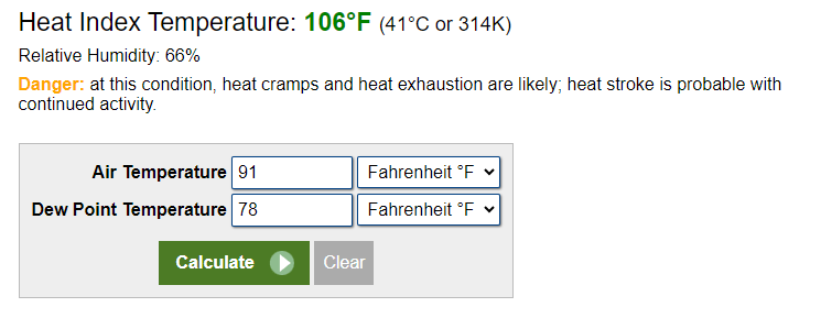
Yesterday’s high temperature there was 91.5 degrees (33C). This is higher than the majority of weather stations on the island because it is not right on the sea, as is every other weather station we have.
That high temperature in combination with the humidity (it is pretty much always this humid on the island) give us a heat index at a whopping 106 (41C). Somebody give me a towel.
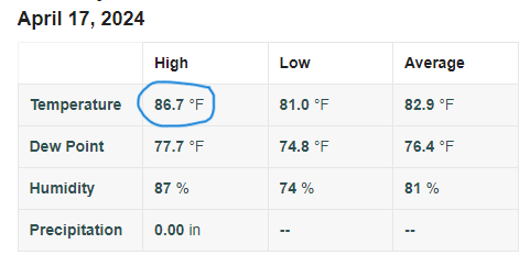
Let’s take a look at the high temperature yesterday at a location called Keyhole Bay Wrightwood (if this is your station, please contact me so I can get your contact info.) It is right on the sea, picking up a nice seabreeze. Let’s see what effect that has on its temps.
Yesterday’s high in West Bay came in at 86.7 F (30.4C). That’s a good five degrees cooler than our inland weather station about a mile away. The difference is caused by the cooling effect of a wind coming off the sea. Evaporating water cools the air.
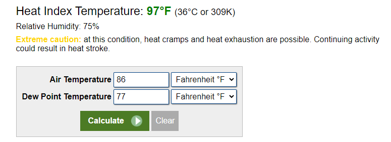
In combination with our humidity, the weather station on the sea in West Bay gives us a heat index of 97 (36C). That’s very hot, but not as hot as the inland weather station.
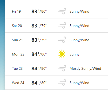
Lots of visitors look at these weather apps for an indication of temperatures. This one is The Weather Channel and it is pretty close on its forecast for lows. We will probably be around 79-80 (26C) for lows, but it is quite low on the forecast highs. We will probably be 87 (on the water) to 91 (inland) for highs (30-33C). This is pretty common on these weather apps. They also get the temperature wrong in the winter when we have northers. A few degrees can make a big difference.
Good morning Bay Islands. Our photo of the day comes from Handford McLaughlin at Camp Bay Beach. Handford has been a great help getting our congregation over to Helene in his safe, sturdy, speedy boat. Look him up at Handfordtours.com.
On our satellite this morning there are a very few popcorn clouds, including one over part of Guanaja at 7 a.m. I guess it’s possible for a small shower, but chances are like 3 percent. We will continue to have 15 mph daytime east winds and 20 mph nighttime east winds and seas 3 feet on the southside and dry conditions into the weekend.
Who needs Taco Tuesday when you can have Taco Thursday during Happy Hour 4-7 p.m. at Ikigai by Robby Molina in French Harbor? $2 tacos and great deals on adult beverages.
Low tides are midnight and noon. Have a great Thursday!
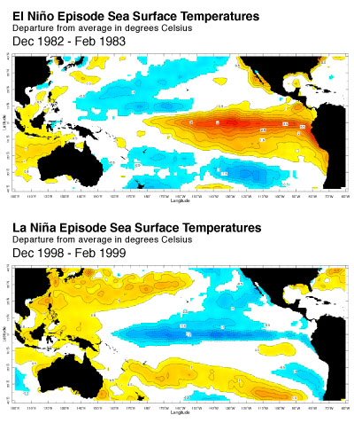
Now that our boring forecast is out of the way, let’s talk about what the months ahead are going to be like. Let’s start with what our weather is normally. If you check out my Q&A here at https://roatanweather.org/frequently-asked-questions-about-roatans-weather/ you’ll learn that I usually don’t do temperature forecasts, because temperature here is almost always the same, especially in the period April-early October. If it isn’t really hot, it’s because it is cloudy and/or very windy. If the wind is calm and it’s sunny, you’re going to be sweating and wanting to jump in the ocean. By that measure, our hottest months are usually May and September, times when we have very little cloud cover and calmer winds (esp. September). June-August is not quite so hot, because we get a few more waves of moisture from our east giving us showers, especially in the mornings. In 2023, we had one of the hottest, driest summers in memory. Our sea temperature got up to 90 degrees (32C) and resulted in coral bleaching. Some people say this is because of our strong El Niño combined with global warming. So, what does this summer hold for us?
According to the US weather service NOAA, forecasters estimate an 85% chance that El Niño will end and the tropical Pacific will transition to neutral conditions by the April–June period. There’s a 60% chance that La Niña will develop by June–August. El Niño is caused by warmer than normal waters in the eastern Pacific. La Niña is caused by cooler than normal waters in the easter Pacific. What does that mean for us? As far as I can tell, not much, at least for our day-to-day weather. I went back through 25 years of rainfall statistics and could find no correlation between El Niño/La Niña years and how much precipitation we got.
And as this chart shows, a strong El Niño or La Niña doesn’t seem to have much effect on our sea temperatures here in the Western Caribbean. This means that the effects on us have more to do with global trends. Are water temps higher globally? Is there less wind shear, and therefore strong hurricanes in the Atlantic making their way here? We will talk about that later in the week.
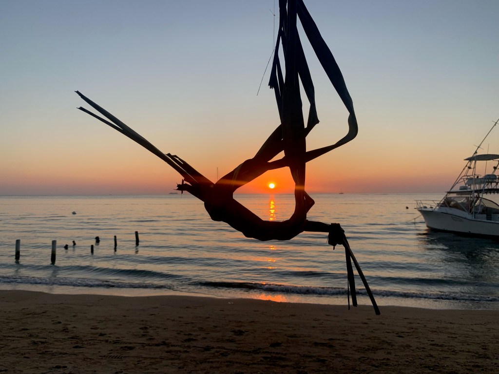
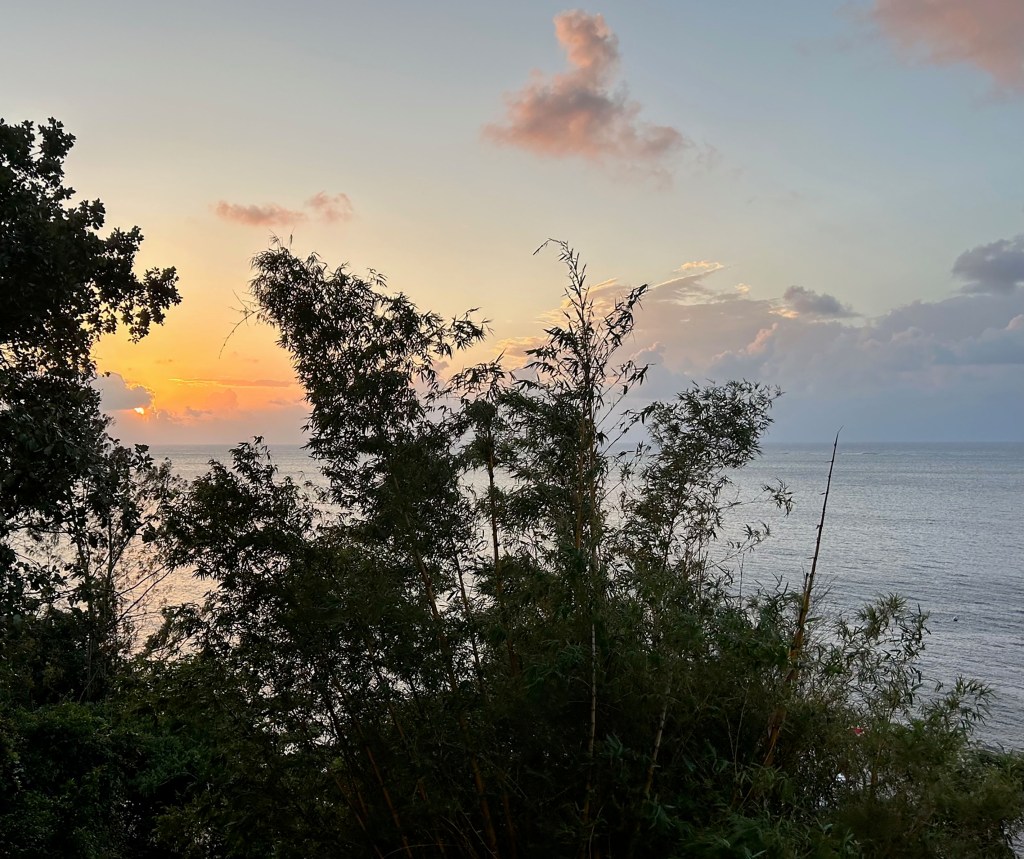
Good morning Bay Islands. Today’s photo comes from Debbie Shortlegs R and is taken from the Pink Seahorse on the south side of West End. The sunset is coming through a bit of palm origami that, to me, looks like a hummingbird. Great artistry. If you want a chance at a $50 gift certificate at Blue Bahia Beach Grill send me your photo with name and location to bookmybio@gmail.com.
Let’s start with our satellite at 7:20 a.m. We have a line of popcorn clouds moving toward the northwest It’s not impossible that someone on the west side or Utila might see a very brief shower out of this, but it won’t amount to much. We will have mostly sunny skies, highs near 90 (32C), east winds 15-20 mph and seas 2-3 feet mostly on the south side the rest of this week. I told you the weather this week was going to be boring!
Boring weather is great if you are scheduled to visit our islands, either by plane or cruise ship. Be sure to check out Jolly Roger Roatan to make the most of our sunny skies and mild winds with a great day on the sea, topped off by lunch and an open bar.
Low tides are 11:30 a.m. and 11:30 p.m. Have a great Wednesday!
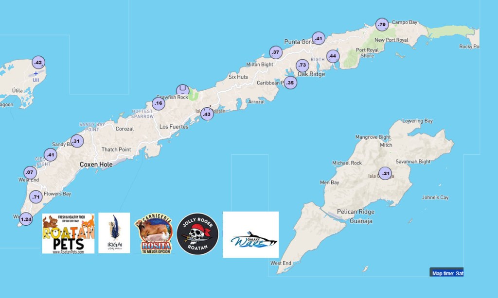
Good morning Bay Islands. Our photo of the day comes from Sandy Soboy, taken on a weekend trip she took to Guanaja on a trip on Galaxy Wave. The Galaxy Wave ferry to Guanaja is a great opportunity for residents of Roatan and Utila to visit the farthest island. I’ve met so many island natives who have never been there. You owe it to yourself to take the trip at least once! A very nice week is in store.
On satellite this morning we see a few popcorn clouds, especially between Roatan and Utila. These clouds are moving southwest. There is a small chance for a shower this morning, especially for Utila, but it won’t amount to much if anything. This week looks pretty dry with only a very slight chance of a shower overnight tonight into tomorrow morning. Next decent chance of rain is in about 10 days, but that is just moisture coming in off the Caribbean to our east. We are done with northers until October.
Wind and Galaxy Wave forecast: Today we have east winds around 15 mph and seas aruond 3 feet, especially on the southside. Winds will increast to 20 mph this afternoon and evening with seas 3-4 feet southside. Tomorrow winds will be 15-20 mph from the east, turning to the northeast in the afternoon, so the northside will get a bit wavier tomorrow afternoon. The rest of the week looks much the same. The weather is really starting to turn boring, so I’m going to be doing some long-range forecasting and looking at what La Nina means for our weather and hurricane season a few months out.
Here’s the Guanaja schedule on Galaxy Wave so you can visit the Bay Islands’ hidden gem!
Low tides are 11 a.m. and 11 p.m. Have a great Tuesday!
Good morning Bay Islands. Our photo of the day comes from Brandon Matz in Sandy Bay and shows a kid (what the locals would call a cipote) doing a wheelie on the beach at sunset. The beach is right in front of Blue Bahia Beach Grill and maybe Brandon will get a $50 meal there if he wins this month’s photo contest. Very small chances of rain will lead into a very dry week ahead.
In our satellite this morning you can see a few popcorn clouds (cumulus) to our north and even more to our south. Unfortunately for us, we are in the dry middle and these clouds are moving toward the southwest. I imagine the Cayos Cochinos are getting some nice showers this morning. There is a small chance for us on the Bay Islands this morning, but this afternoon should be mostly sunny. Another small chance will happen tomorrow morning, and maybe a 10 percent chance overnight Monday night into Tuesday morning, but after that we are dry as a bone.
Wind and Galaxy Wave forecast: We start the day winds fairly light at 10 mph from the north/northeast, but waves are 3-4 feet on the north side. This afternoon winds will pick up to 20 mph from the northeast, keeping our seas around 4 feet north side. Tomorrow we will have another day of light morning winds and winds in the afternoon 15-20 mph from the northeast, with seas 2-3 feet north side. Tuesday through the rest of the week we will have easterly trade winds, but only around 20 mph, so seas should stay around 3-4 feet, mostly on the south side. We won’t have those 30 mph overnight winds we’ve had previous weeks.
Today is $18 Lobster Special day at Ikigai by Robby Molina in French Harbor. This is a good deal by itself, but the fact that it includes a complimentary adult beverage makes it a great deal.
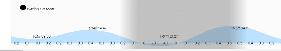
Low tides are 9:30 a.m. and 9:30 p.m. Have a great Sunday!
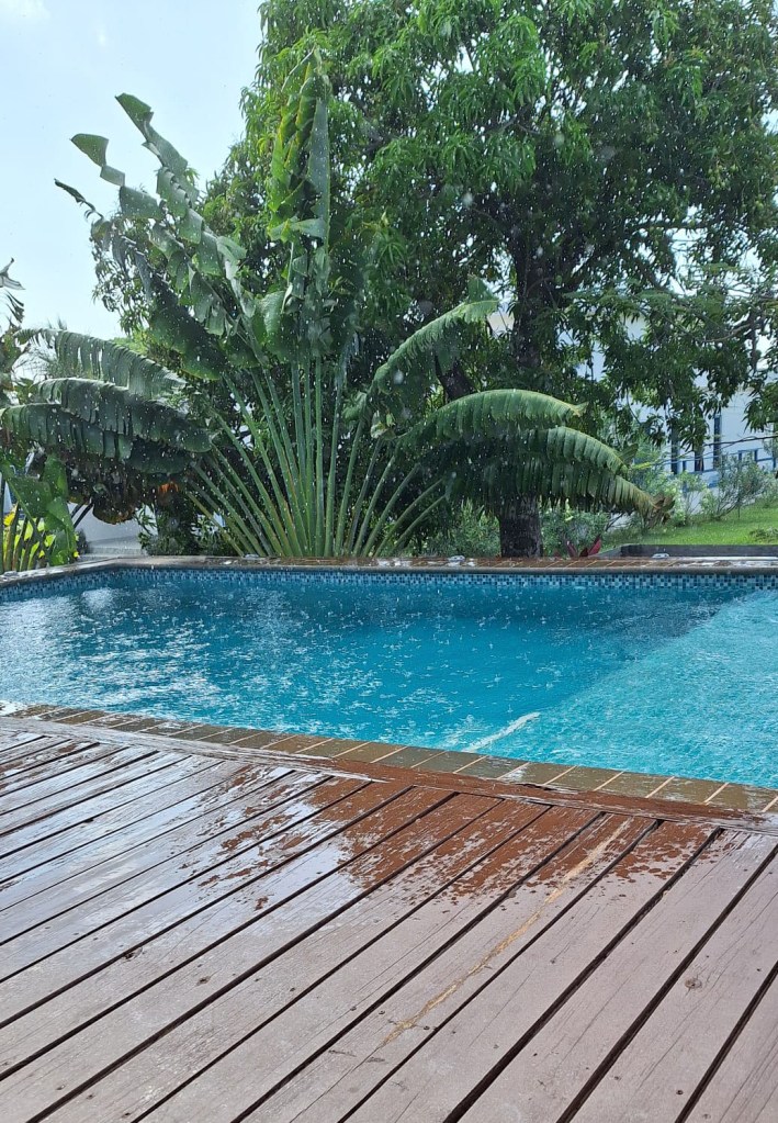
Rain, glorious rain. Our photo of the day comes from Paula Chamernick in Guaiabara Beach Big Bight. The chances of rain finally broke through overnight and into this morning. Sadly, from here the chances of rain go down, but will be around through Monday morning.
On satellite we can see lots of popcorn clouds around, so there will be a chance of rain showers today, especially this morning. But we will have partly cloudy skies with periods of sun. Where there are rain and clouds it will be a tad cooler, but when you get in the sun, it will still be muggy and hot. We will have chances of rain tonight into Sunday morning and Sunday night into Monday morning. Sunday and Monday afternoon should be dry and mostly sunny.
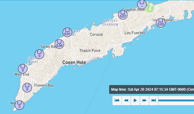
Here are the numbers you are all interested in. West Bay was the big winner with an inch and a quarter. Most of the rest of us got between a third and three quarters of an inch.
Wind and Galaxy Wave forecast: We start the day with with north winds at 5 mph and seas only at two feet. Those conditions will last most of the day. This evening winds will pick up to 15 mph from the northeast and seas will pick up to 3 feet. Those conditions will continue through tomorrow. Next week we will have easterly trade winds, but not as bad as in recent weeks. Winds will be mostly 15 mph during the day and 20 mph at night and 3-4 foot seas, mostly on the south side.
High tides are pretty low and lowest tide will be 8:15 mph. Have a great weekend!