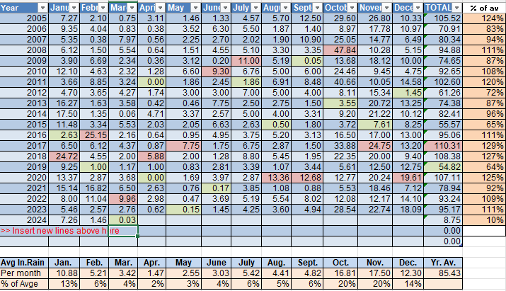
We will go with Megan Mitchell’s reading of .03 of an inch of rain for the month in Sandy Bay, since it was likely accurate and about average for the island. This was the driest March since records started being kept in 1994 and well below the average of 3.42 inches. This was after an unusually dry February, so my cistern is complaining because I rely on rainfall since the powers that be in Jonesville Point refuse to let me share the well (that’s a story for another day). April is our driest month of the year on average, with only an inch and a half. The long-range forecast is trying to give us some hope of rain, especially toward the middle of the month, but we’ve been deceived before. So it looks like those water trucks will be staying busy.
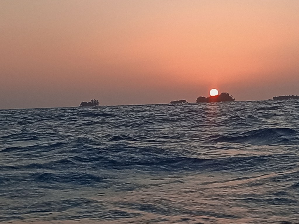
Good morning Bay Islands. Our photo of the day comes from Dean Olds at Villas del Playa at West End. As I was choosing photo of the day, Sailing by Christopher Cross came up on my music mix, so I think it biased me. We’ve had strong winds to sail with. I got up to 35 mph last night. We have one windy night left before we go into a calmer period.
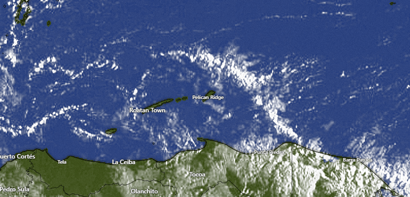
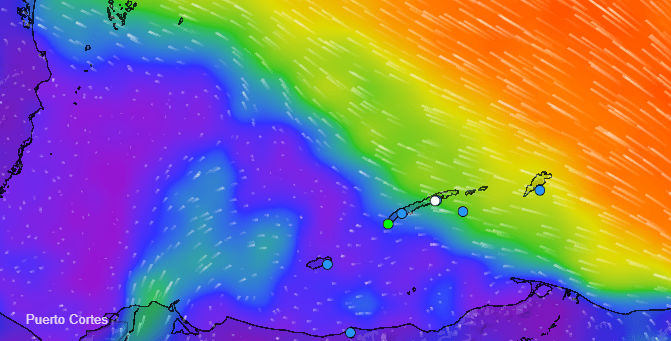
On the satellite can see the front to our north that will get close Thursday and Friday. In the circled area we can see our clear skies. This morning at 6:30 a.m. we have already started our mid-morning calm-down to winds 10-15 mph from the southeast with seas calming to 3 feet on the south side, which we will have much of today before getting much windier (25-30 mph) tonight.
Midday tomorrow we will start having calmer winds and a turn to the northeast at 5-10 mph.
Thursday winds turn to the west at 15 mph. Thursday we will be partly cloudy and have a 20 percent chance of an isolated shower. That chance will increase to 30 percent for Friday morning.
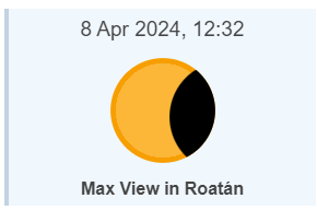
If you were fortunate enough to be on the islands Oct. 14 to see the total eclipse you got a once or twice-in-a-lifetime opportunity. On Monday, we will only be getting a partial eclipse with 40 percent of the sun covered up by the moon. That may sound like a lot, but the sun is very bright, so it won’t make it much darker here. If you want a complete eclipse experience, you need to go to Mazatlan, Mexico or Austin, Texas (though both those places may be getting cloudy skies that day, and even we here in Roatan should have morning clouds that day). I would suggest you look, instead at the light through the leaves of trees. When you look on the ground, the light will be reflected on the ground with a mirror image of the sun in a crescent shape, reflecting the portion that is being eclipsed by the moon.
I was so pleased that a pet-lover was the winner of the March contest and $50 in Roatan Pets, but not nearly so pleased as her poochies will be. Hopefully a food-lover winds the April prize of $50 worth of food from Blue Bahia Beach Grill.
Good morning Bay Islands and welcome to April. Our photo of the day comes from Lisa Johnson and was taken at Brady’s Cay, near French Key. We will continue to have strong easterly trade winds a couple more days before we get calmer on Wednesday.
Our skies are mostly clear and we were quite windy last night, with winds up to 30 mph. We will continue to have east winds 20-25 mph during the day and 25-30 mph at night with seas 3-4 feet on the southside today and tomorrow. Wednesday winds will be much calmer, with north winds 5-10 mph and Thursday we will have northwest winds 10-15 mph. A cold front Thursday and Friday gets close, but not close enough to give us big rain chances.
If you are coming to Roatan, either with a cruise or by air, check out Jolly Roger Roatan for the perfect daytime excursion.
We start the day with a few popcorn clouds, especially to the east of Guanaja. We can’t rule out someone seeing a small shower. On our weather network, it looks like the station between West Bay and West End got .01 of an inch around 2 a.m. If anyone sees rain, it will be very brief and hardly get the ground wet. Today and tomorrow we get our strong east winds back, with daytime winds 15-20 mph and nighttime winds 20-25. Tuesday is a little calmer and Wednesday and Thursday will be much calmer. Thursday and Friday we will have a small chance for an isolated shower.
Don’t forget the special Galaxy Wave schedule that runs through tomorrow.
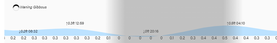
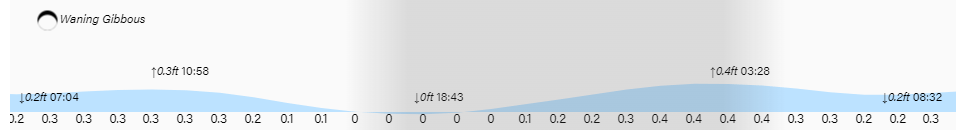
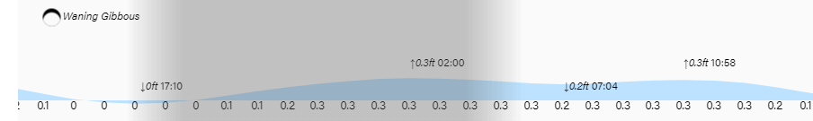
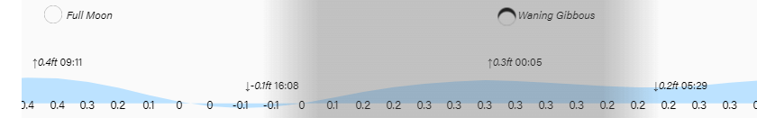
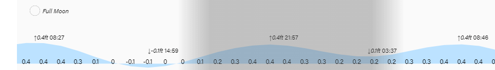
High tides continue to be quite low. Have a great Sunday!
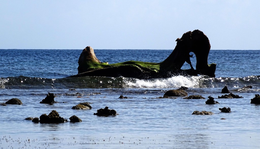
Good morning Bay Islands. Our photo of the day comes from Lise Desgroseilliers right here on Jonesville Point. It is a large driftwood that I’ve been staring at for several months and has now taken on the look of a dragon. Today is the last day to give a like to a photo for March. The five most-liked photos compete tomorrow for $50 in Roatan Pets food.
Our big story today is the cooler temperatures. Jonesville and French Cay got down to 67 degrees (19.4C) this morning with comfortable dewpoints in the mid 60s. We will have a mostly sunny day with highs only around 83 (28.3C). Winds will be from the east 5-10 mph and seas 2-3 feet on the northside. We’re starting quite calm on the south side, but we should get 2 foot seas by day’s end. Tomorrow and Monday we will see stronger east winds 15-20 mph daytime and 20-25 mph nighttime with seas 3-4 feet on the southside. There will be a small chance for a shower tomorrow morning. By Monday we will be back to warmer temperatures with highs around 86 (30C). Winds will turn to the northeast Wednesday and the northwest on Thursday and the GFS is wanting to give us a small chance of rain Thursday as a weak cold front makes its way in.
I’m happy to announce that Blue Bahia Beach Grill will be the sponsor of the April photo contest. The winner will receive a $50 gift certificate to the restaurant on my favorite beach in Roatan.
High and low tides will be quite mild. Have a great holiday weekend!
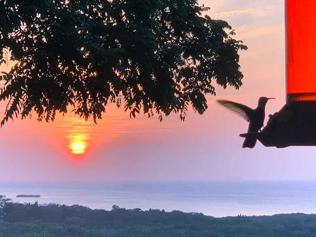
Good morning Bay Islands. We have a gorgeous work of creation as our photo of the day today. Did you know hummingbirds can beat their wings up to 5400 times per minute and can’t walk? If you like this photo Dion Bramblett of Sandy Bay may have a chance at $50 in Roatan Pets food.
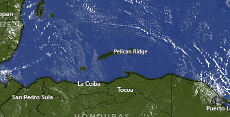
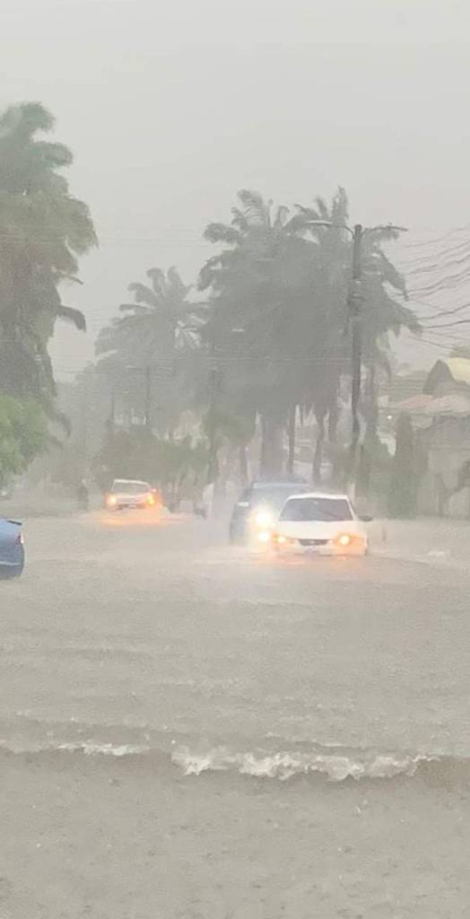
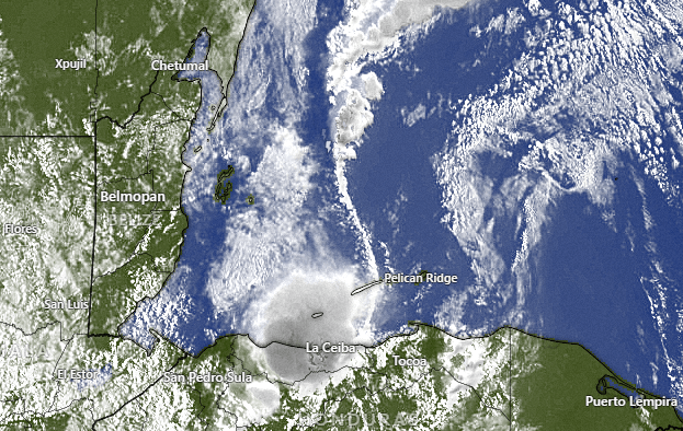
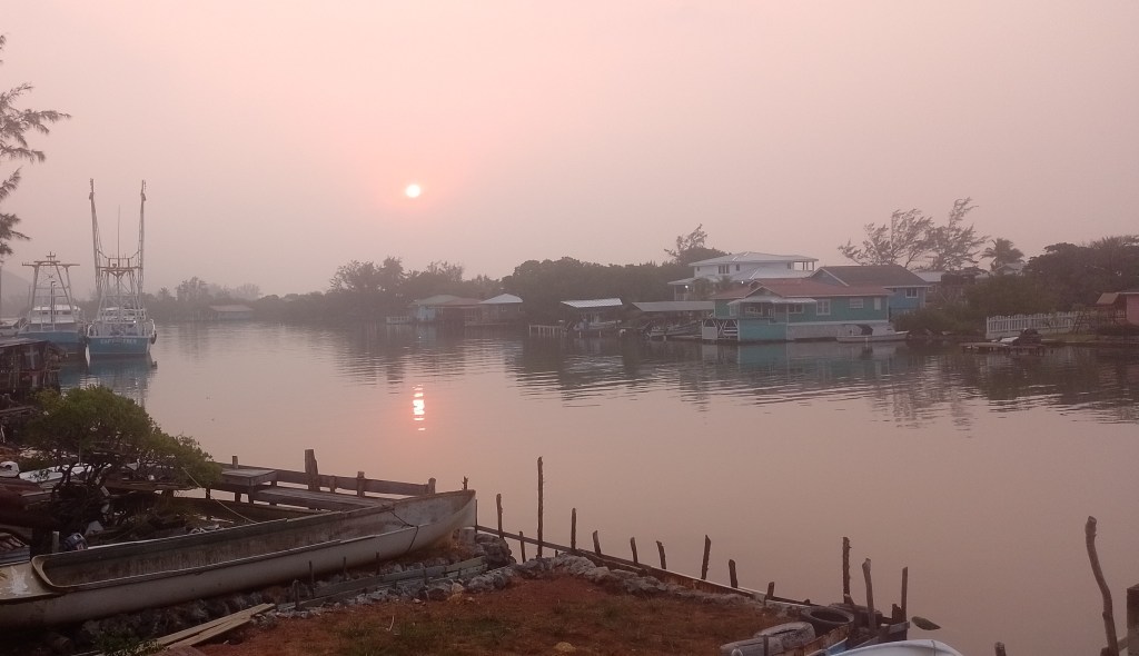
While we were getting virtually no rain yesterday, this was the scene in La Ceiba. This has been a very odd cold front. Basically it rained all around us but not over us. Someone should have had a beach wedding yesterday. That always seems to make it rain 🙁
Even if we didn’t get much rain, the rain on the coast should help with the smoke, at least for the next week or so, giving us clearer skies. Temperatures will be mild this weekend. We will be dry, though someone might get a small shower on Pascua Sunday morning.
We start out with north winds 15-20 mph and seas 5 feet on the north side. The winds aren’t quite as bad as we feared, and the seas get better the further south you go, so those of you riding the Galaxy Wave will have a little chop, especially if you are coming back to Roatan, but not too bad overall. Winds will stay from the north around 15 mph and seas around 4 feet today. Winds turn to the east tomorrow around 10 mph and seas at 2 feet.
The cold front has brought incredibly cool temperatures in the 50s and 60s for the Yucatan Peninsula. We won’t get this cool, but we should have lows the next couple of mornings in the mid 70s and highs right around 83, so a lot better than the 90s we had the past week.
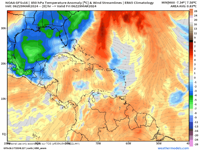
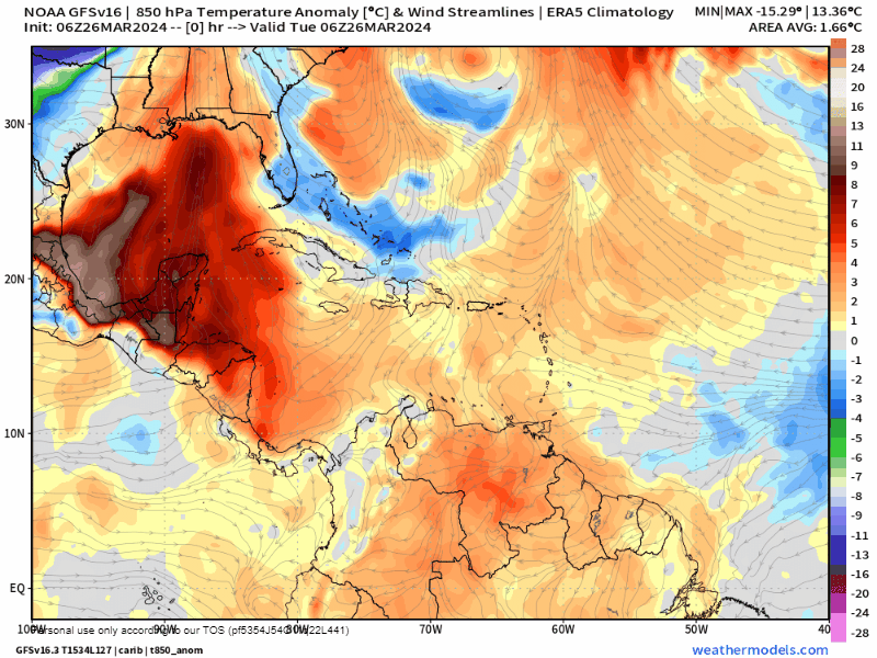
After two days of cooler temperatures, next week looks warm again, with highs around 88 and lows around 80. The GFS wants to bring a cold front in Friday or Saturday with a small chance of rain, but also some cooler weather for next weekend. This is a loop showing how above or below average our temperatures will be in the atmosphere overhead.
Even the high tides are pretty low right now. Have a pleasant and safe holiday weekend and watch out for the folks who shouldn’t be driving!
Good morning Bay Islands. Our photo of the day comes from Cathy Strine at Camp Bay Beach, where LOTS of folks are going to be this weekend. We have a storm over La Ceiba at 7:15 a.m. and the hope of rain today. The front is passing over us now.
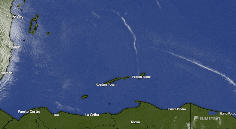
In the satellite you can see the front extending north to south. On the west side of the front we have gusty west/northwest winds around 20 mph. Those will continue most of the day today. Scattered showers will be around all day into tonight. Tomorrow we will have north winds at 20-25 mph giving us 5 foot seas on the north side. Any rain tomorrow morning will be light.In the satellite you can see the front extending north to south. On the west side of the front we have gusty west/northwest winds around 20 mph. Those will continue most of the day today. Scattered showers will be around all day into tonight. Tomorrow we will have north winds at 20-25 mph giving us 5 foot seas on the north side. Any rain tomorrow morning will be light.
In the infrared satellite you can see that most of the rain is focused on the mainland, but there are clouds extending to Utila and west side of the big island
At 7:15 we have a few stations reporting rain in West End and near Mud Hole. If you see rain, let us know.
This is a big day for trips to and from the mainland, with four round trips on the Galaxy Wave!
Good morning Bay Islands. Our photo of the day comes from Marcey McNab in Oak Ridge and perfectly captures the smoky haze we’ve been dealing with. Fortunately we have a cold front coming tomorrow just in time!
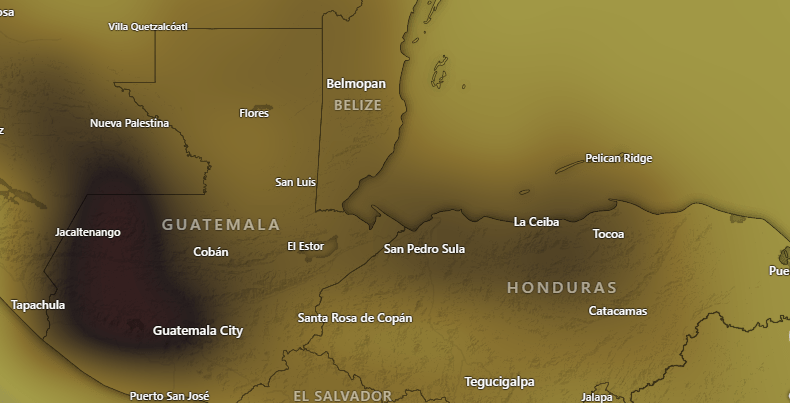
This is a map showing the levels of carbon monoxide in the atmosphere. CO is produced by burning and we have a lot of it in our air. This can mean breathing issues for sensitive folks, so one more day of caution outside before our front comes to clear our air.
Today will be hazy and hot. Yesterday we got to 90 at the airport and many of us got a little higher than that on our thermometers. I hit 92 here in Jonesville Point and Sandy Bay hit 93. These are unheard of temps for March around here. Fortunately we will have relief with clouds and rain tomorrow, followed by the north wind Friday. Rain will be off-and-on with perhaps some thunder. Rain will start around 6 a.m. and scattered showers will be around through the night. Rain should come to an end Friday morning. We should get 1-2 inches across our islands. Most of Good Friday and Saturday will be sunny and dry. There will be a small chance of a morning shower Sunday morning.
We will have west winds 10-15 mph this morning, but those should calm this afternoon. Tomorrow we will have west/northwest winds 15-20 mph and gusty in squalls. Friday we will have north winds 17-22 mph and seas 5 feet on the north side, calming slightly in the afternoon. Saturday winds will be much lighter from the east, 5-10 mph. Sunday we get a return to strong easterly trade winds.
Just a reminder that there is a special midweek ferry to Guanaja this morning and an extra roundtrip to the mainland on the Galaxy Wave!
Good morning Bay Islands. Michelle Widd had a great idea. Let’s put together flora, fauna and a beautiful sunset. Here’s her shot from Palmetto Bay with Man o War Cay in the background. Like her photo for a chance at $50 in Roatan Pets food in the contest on Pascua Sunday. Winds will continue to be confusing this week, and rain is moving more toward Thursday and less toward Friday in the forecast. Just a heads up that I will be posting a video later today about our incoming cold front.
Let’s start with today and tomorrow: As you can see in the 7 a.m. wind map, we start the day with calmer winds west Roatan and Utila, but with 10-15 mph east winds east Roatan and Guanaja. This should more or less continue through the morning, At midday our winds turn to the northeast at 15 mph. Overnight into tomorrow morning our winds turn to the west at 15 mph, so there will be 3 foot waves, even for normally calm West Bay. Winds get calmer tomorrow afternoon with no rain either day.
We will have a cloudy day on Thursday and most of the models say rain chances will increase through the day with scattered showers, with the best chance of heavy rain Thursday night. Friday morning there will be some lingering showers but things should clear up a bit. It should be pretty wavy for the folks with a day off to go to Camp Bay beach on the northside, with 20 mph north winds that day. Saturday looks pretty dry but Pascua Sunday morning will have a small chance of a morning shower.
Regardless of the rain amounts, we should get a cooldown. We’ve been very hot as you can see in this temperature anomaly map, which shows how much above or below normal the heat over our heads is. Yesterday the airport got to 88 degrees (31C) and many of us got to 90 (32C). I don’t have to tell you that with a dewpoint at 80 (27C) that made it pretty hot. Thursday will be cooler because we will have a cloudy day, but Friday and Saturday will be quite comfortable even in the sun, with highs probably around 82 (28C) and lows perhaps around 72 (22C). Even after we get back to warmer weather on Pascua Sunday, it will be more normal for this time of year, 84-85 (29C).
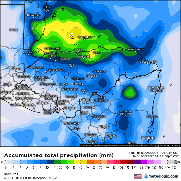
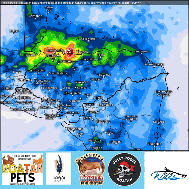
The ICON is the most optimistic, giving us 2 inches of rain through Good Friday morning.
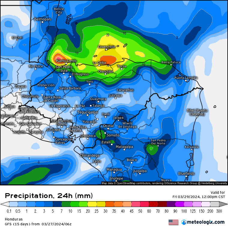
Here is the GFS which puts us right around an inch.
Here is the Euro model for rainfall through Good Friday morning, which gives us less rain, probably half an inch, with Puerto Cortes having all the fun.
A big shoutout to Roatan Pets for sponsoring this month’s contest. Please remember that 10 percent of proceeds goes to the needy pets supported by Roatan Operation Animal Rescue, a worthy cause if ever there was one.
Our photo of the day comes from Anja Weyers in Sandy Bay and shows just some of our beautiful island flora, called frangipani or plumeria. I have gotten some feedback to see more flora and fauna in photos of the day and fewer sunrises and sunsets. What do you think? Let me know your thoughts.
Today is the easy day to forecast. We start with 25 mph east winds and seas 4 feet on the south side. That should ease a bit to 15 mph midday but get back to 20-25 mph east winds by evening. We will have clear skies and no rain today.
Tuesday through Thursday the wind situation will be hard to predict, because we have winds from different directions moving in and out. Tuesday looks like the calmest day with winds around 10 mph, but from various directions depending where you are on our islands. Wednesday looks like a day of 15 mph west winds. Thursday winds are calmer around 7-12 mph but also start to turn to the north.
Models are still looking good for us to get rain from Thursday evening through the day on Friday. They disagree somewhat on whether we get more rain late Thursday or early Friday, but that is the time period to look for rain. Also, Friday looks to be a day of brisk north winds and waves on the north side, though the EURO wants to put the biggest waves into Friday evening, whereas the GFS says the morning will be windy.
With a complex wind pattern, you need to choose Jolly Roger Roatan for your excursion. They know how to get you to a calm cove to make the most of you time on the island!
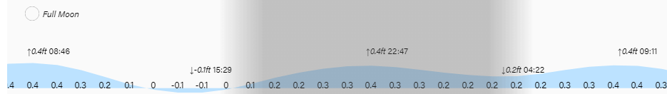
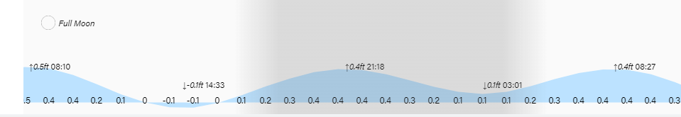
Low tides are 2:30 p.m. and 3 a.m. under a full moon. Have a great week!