Good morning Bay Islands. We got that evening shower we were talking about yesterday, but the east side got it more than others around 9:30 p.m., with nearly an inch in some areas, while by the time you got west to West Bay they only had .05 and Utila got none. Today should be generally dry and sunny with east winds 12-17 mph and seas around 3 feet. Tomorrow morning should be one of the calmer mornings we’ve had, with east winds 5-10 mph and seas 1-2 feet. Today through Friday morning chances of a small shower are low, but not zero. Next best chance of a big rain is Friday evening into Saturday. Have a great Wednesday!
July 21, 2026
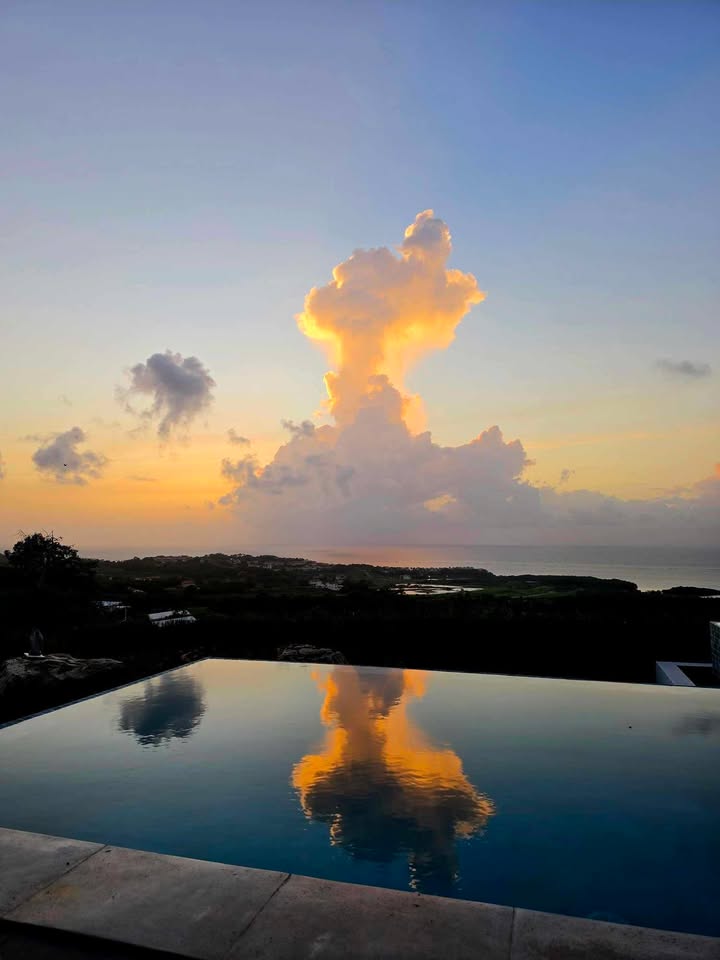
Good morning Bay Islands. Our photo of the day comes from Phil Cashin and shows a sunset over his reflecting pool with a cumulus cloud in the background. This is the kind of weather we have this morning — mostly sunny but with a cumulus cloud that around 8 a.m. brought a quick shower and .02 of an inch to Guanaja. We should stay mostly sunny today but toward evening there is an increased risk of a shower.

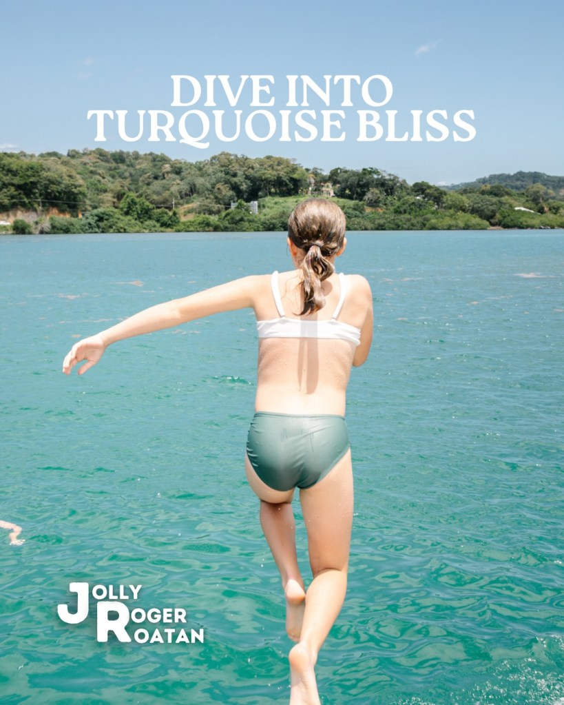
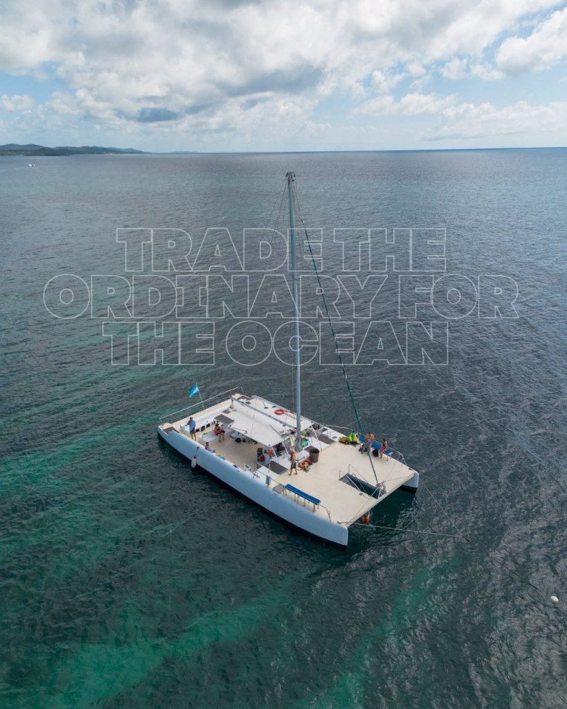
Ready to experience Roatán’s #1 catamaran tour?
Visit our website to explore our tours, check availability, and reserve your spot in just a few clicks.💻
From snorkeling the Mesoamerican Reef to island-style lunch, refreshing drinks, music, dancing, and breathtaking sunsets, your unforgettable day starts here.🤿🌞🐠
🌴 Book today and let the adventure begin!
🌐 www.jollyrogerroatan.com
📞 +1 (561) 451-5377
Winds and seas today are moderate from the east at 10-15 mph and 2 feet. They will get a little stronger this evening and tomorrow at 15-20 mph and 3 feet.
Low tide is 10 a.m. Have a great Tuesday!
July 18, 2026
Good morning Bay Islands. At 7:45 we have a few clouds here and there and some rain around — Punta Blanca got about .02 at 7:30. Any showers should be quick and light and mostly gone by mid-morning. The afternoon should be dry and partly cloudy to mostly sunny. Tomorrow looks a lot like today and Monday and Tuesday it is unlikely we even get a morning shower.
Winds and seas are a bit better than we’ve been experiencing, from the east at 12 mph and seas 2 feet. Winds and seas will stay right around there through the weekend.

Today is the last day to get your steaks and chops at Carniceria Rosita in French Harbour or Coxen Hole before tomorrow’s World Cup finale!
Tides will be quite moderate today.
Have a great weekend!
July 15, 2026
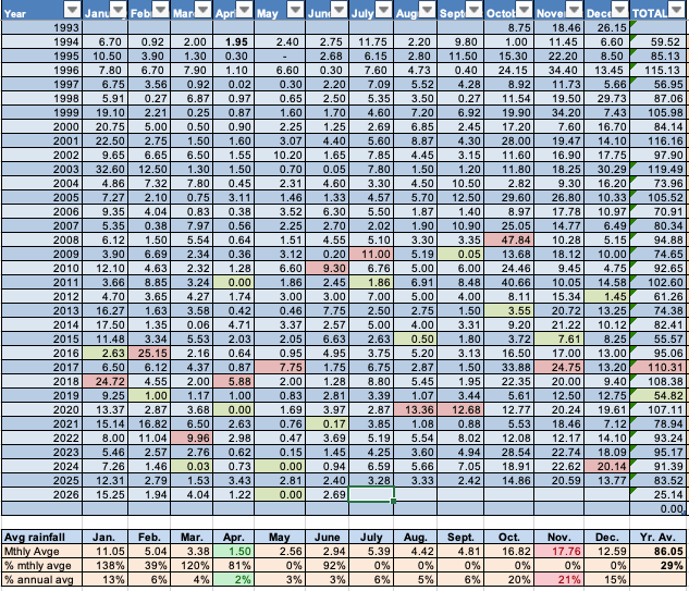
Good morning Bay Islands. I know it looks like a monster is eating us at 6:45 a.m., but this is actually a storm system moving in from the east. And its bark is worse than it’s bite. These clouds have been over Guanaja for over an hour, and it has received only about .13 of an inch. Most of the rain in this storm in north of us this morning, but we will have scattered showers today after many of us got 1 to 1.5 inches of rain yesterday.
The air overhead gets quite a bit drier starting tomorrow so rain chances will be low the rest of the week, with a consistent east wind around 20 mph and seas 3 feet.
Getting ready for your World Cup cookout for England versus Argentina? Run down to Carniceria Rosita in French Harbour or Coxen Hole for your steaks, ribs, chicken and pork chops and grab a couple of spicy chorizos while you’re at it!
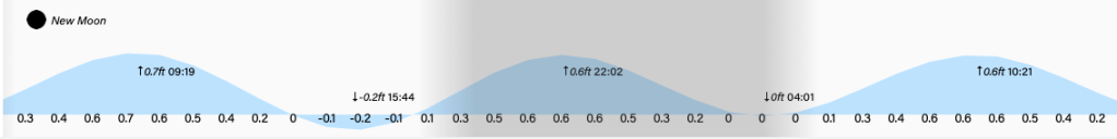
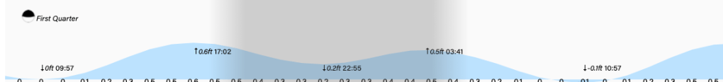
Our tides continue to be quite low at 3:45 p.m. Have a great Wednesday!
July 14, 2026 forecast for Roatan and the Bay Islands
Good morning Bay Islands. We have quite a bit of cloud cover, but not a lot of rain this morning. The exception is Utila which is seeing a bit of sun at 6:30 a.m. The forecast is still calling for scattered showers today and tomorrow with east winds 15-25 mph and seas 3-4 feet.

Roatan Radio is now available on Amazon!
A wild Caribbean story of music, mayhem, island life, and the unforgettable characters who helped shape a one-of-a-kind radio station. This is the story of the station’s evolution — from its birth on Roatan to the voice you hear today as 101.1 Blue Wave Radio. Funny, chaotic, heartfelt, and full of tropical adventure.
Scan the QR code to order your copy on Amazon.
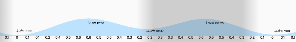
The tide will be quite low at 3 p.m. Have a great Tuesday!
July 12, 2026
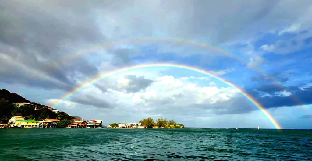
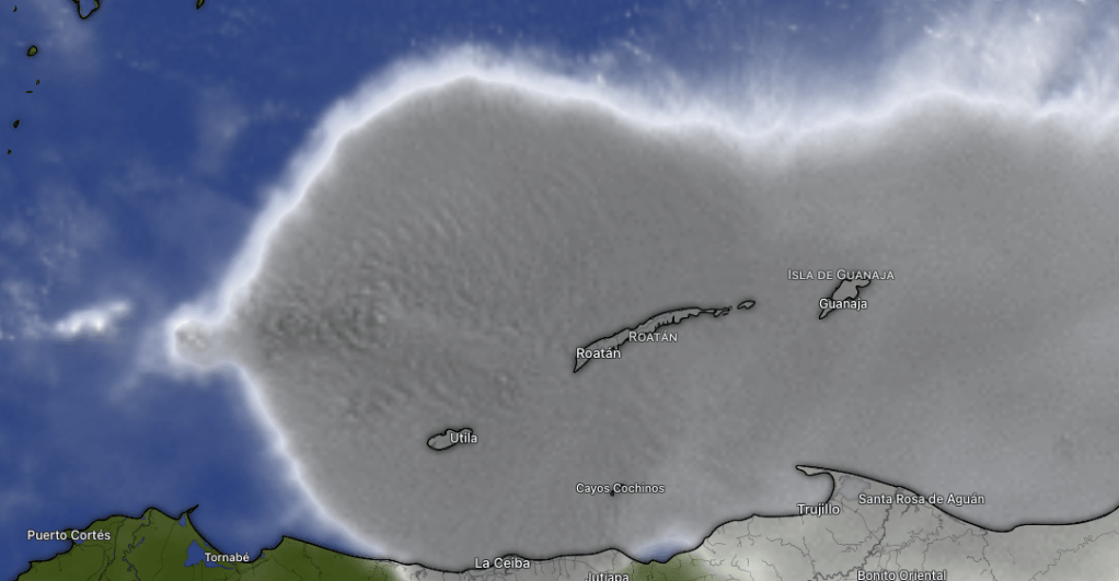
Good morning Bay Islands. Our photo of the day comes from Melanie Cooper who captured this double rainbow over Oakridge Cay. There might be another one today. In the last hour (6-7 a.m.) about a tenth of an inch has fallen on Camp Bay and Diamond Rock after about a half inch yesterday. The west side has gotten much less rain. All of us should get plenty of rain this week.
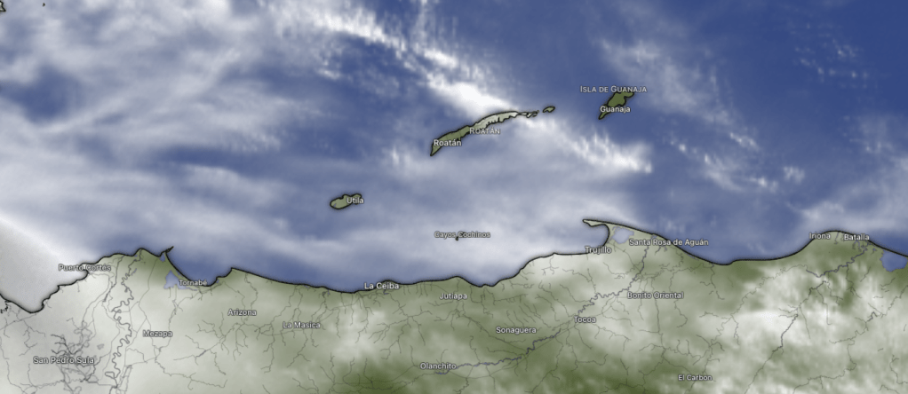
Here’s the 7 a.m. satellite and you can see thicker clouds over the east side of the island. Rain amounts should be low today with partly cloudy skies. Rain chances are a little better tomorrow and really good Tuesday through Thursday, with periods of downpours likely.

Here’s the GFS model of rainfall through Thursday. You can tell there will be A LOT of rain over what I call our rainfall factory on the Mosquito Coast. As it moves west these storms often weaken, but this forecast is still calling for about three inches of rain for us.
Trade winds today through Thursday will remain fairly strong, around 20 mph and seas 3-5 feet.

Did you know you can place orders for Carniceria Rosita via WhatsApp?
Coxen Hole: https://wa.me/50433504939
French Harbour: https://wa.me/50433351055, http://wa.me/50494082388
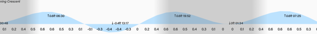
The tide will be super-low a little after 1 p.m. Have a great Sunday!
July 9, 2026
Good morning Bay Islands. Our photo of the day shows a ray of light coming through the clouds over Infinity Bay. Manny Selva took it while visiting the island with his wife Judi and their kids and grandkids.
We haven’t seen many rays of light this morning, but Utila finally got a big rain that its been waiting for a couple of months.
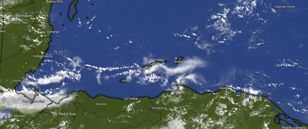
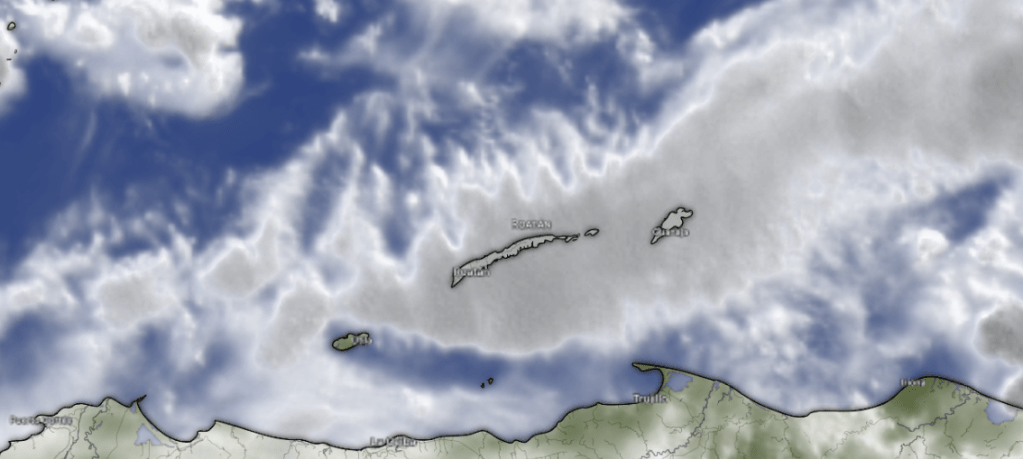
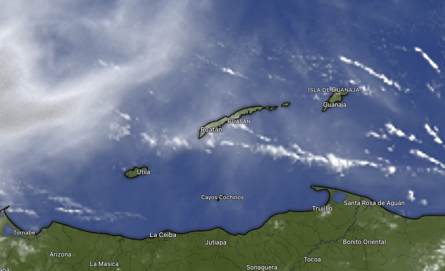
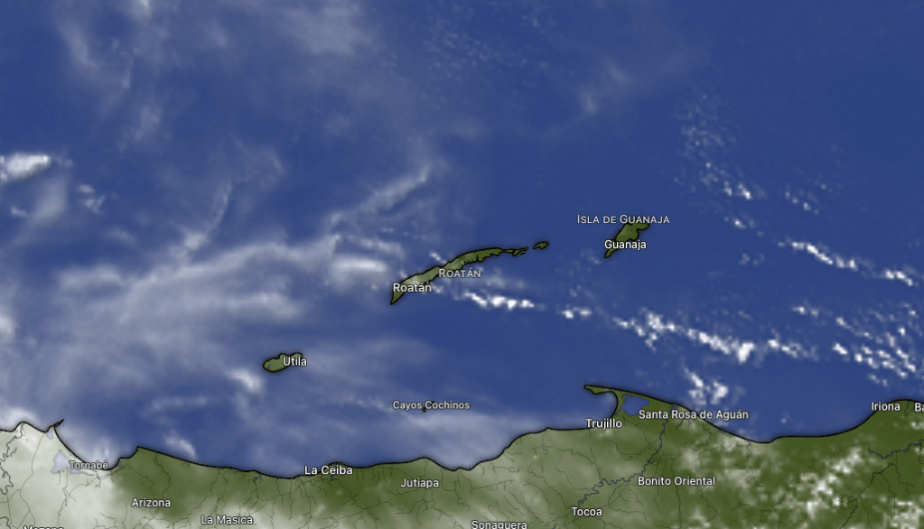
In this satellite image taken at 6 a.m., you would think all the islands were getting a good rain, but you can see the clouds to the west are more intense, with ridges at the top that indicate deeper convection and therefore more intense rain. The west side has only gotten a few hundredths of an inch this morning while …
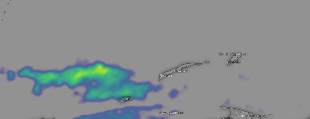
… on radar you can see lots of rain toward Utila at 6 a.m. It has decreased in intensity as of 7 a.m. but still some showers are falling. Pumpkin Hill on North Utila has gotten almost 2 inches while most other stations on the island have gotten almost an inch. This storm should continue weakening as the morning goes on, but we will keep a chance of scattered showers through the day and into tomorrow morning. Partly cloudy skies and an occasional shower will continue into the first part of the weekend. Right now Sunday and Monday look like our best chance at completely dry days.
If anyone knows how to dodge the raindrops, it is Jolly Roger Roatan, who will find a quiet cove for your island excursion and get you back on board ship right on time.
Trade winds from the east will continue to be around 15 mph and 3 foot seas days and 20 mph and 4 foot seas overnights.
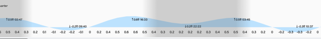
Low tide is 9:40 a.m. Have a great Wednesday!
July 2, 2026
Good morning Bay Islands. Our satellite this morning looks very similar to yesterday, with mostly high cirrus clouds and a few popcorn clouds to our south at 7:30 p.m. Our forecast is dry through the weekend with typical easterly trade winds 15-20 mph and seas 3-4 feet. We had a question about El Nino’s effect on our weather,
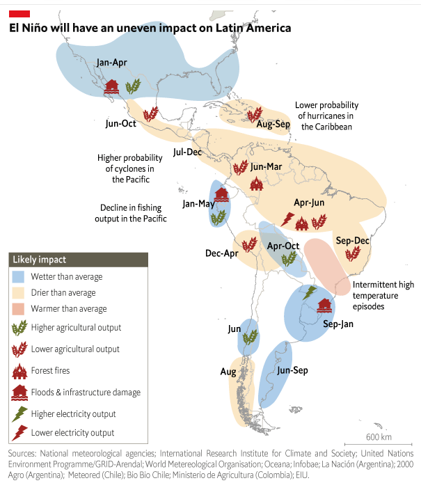
This is a nice summary of the effects of El Nino (this year is supposed to be an especially strong one) on the Americas. You will note the higher latitudes (further north and south from the equator) should be wetter, while generally areas closer to the equator should be drier. You will also note that our area of the Caribbean is not in a marked circle for drier conditions. I have compared our rainfall totals with El Ninos (and La Ninas) and haven’t found any real pattern, so I don’t think we can say with certainty we will have a drier summer than normal. That said, one definite pattern that is good for us is a lower likelihood of hurricanes. Of course, that isn’t zero, so we still need to be aware, but strong El Ninos generally decrease Caribbean hurricanes.
We are in peak World Cup season, and nothing goes better with the taste of victory than a tender cut of meat from Carniceria Rosita in Coxen Hole or French Harbour.
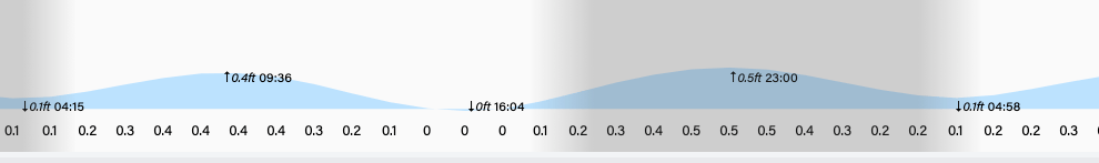
Low tide is 4 p.m. Have a great Thursday!
Rainfall for June 2026
For consistency’s sake, we will stick with Sandy Bay for our island rainfall for June, where they picked up 2.69 inches with rains the last week of the month breaking the drought and is similar to Guanaja’s total. The west side of Roatan generally got just under 2 inches, but West Bay (.33 of an inch) and Utila (.25) were the big losers.
Looking forward to July, on average, squalls increase during this month, giving us an average over 5 inches. Let’s hope we get it. We need it. The forecast looks a little rainier starting next week.
July 1, 2026
Good morning Bay Islands. Our photo of the day comes from Patric Lengacher, who captured this storm over Coxen Hole on June 20.
The storm we got yesterday morning brought over an inch of rain to Sandy Bay and around a half an inch to most west side locations, but sadly only about a quarter of an inch for West Bay, .04 for Guanaja and none for Utila. The forecast is also looking dry.
Our satellite at 6:45 a.m. shows mostly high, cirrus clouds giving us mostly sunny skies, though there are a few popcorn clouds south of Coxen Hole that may have a very small shower in them, so we can’t rule out someone seeing a quick shower, but it won’t amount to much. Our forecast overall is quite dry through the weekend. Starting Monday of next week we should see an increase in scattered overnight and morning showers. Winds will stay around 15-20 mph from the east and seas 3-4 feet.
Step aboard Jolly Roger Roatan and turn your day into a true Caribbean adventure,spacious catamarans, breathtaking views, snorkeling, and unforgettable moments at sea.
Low tide is 3:30 p.m. Have a great Wednesday!
