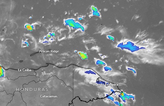
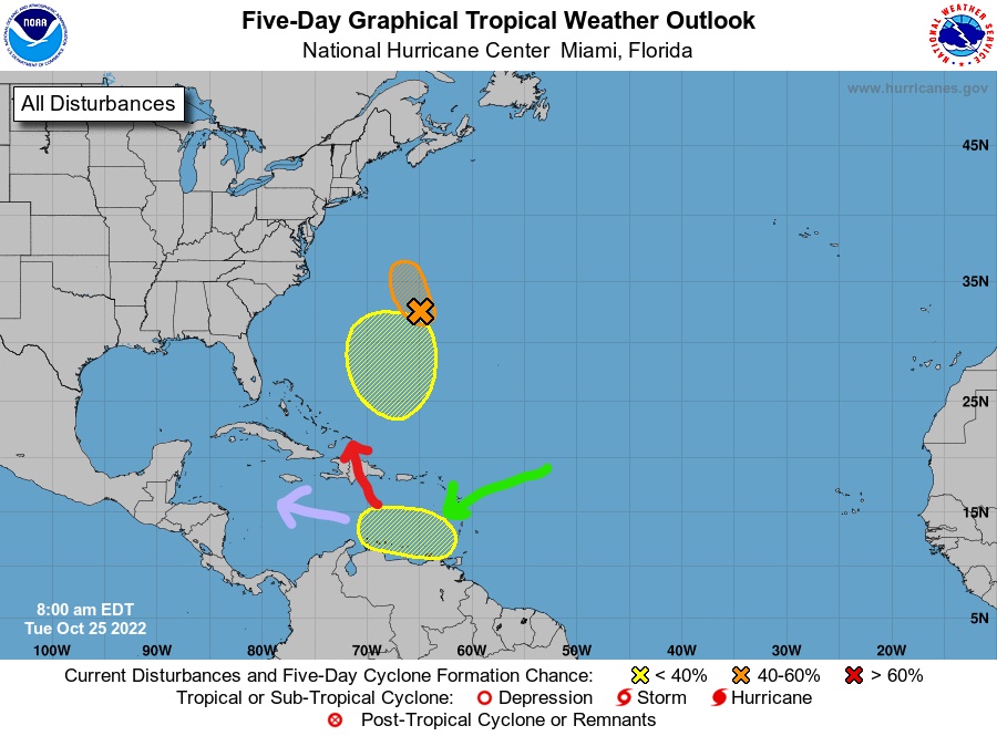
Oct. 1, 2022

Oct. 1, 2022: Good morning, Roatan. Rainfall totals yesterday were generally between a quarter and a half inch, but midisland, Coral View got 1.19 inches and French Harbor got 1.37 inches.

This weekend definitely looks like a time for us to dry out. We’ll keep a 30 percent chance of a shower today and tomorrow under partly cloudy skies. Today we will keep a west/northwest breeze 10-15 mph and seas 2-3 feet on the northside, but those winds and seas get much calmer tomorrow. Enjoy this relatively dry weekend because starting Monday things start looking wetter for the upcoming week. For the most part, winds stay calm, except during squalls. Have a great weekend!

Tropical outlook for Sept. 30, 2022

Tropical update for Sept. 30, 2022: We should take note that there is an area coming off the coast of Africa with a 50 percent chance of development over five days. While this particular wave probably isn’t of concern to us, we should be concerned that in a week or so, the Caribbean will return to being a place where there is a decent chance of a tropical storm brewing.

This map shows an area in blue off the coast of Nicaragua with a 30 percent chance of hosting a tropical depression on Oct. 9. Obviously computer models this far out are not very accurate, but the fact remains that 10 days out we should keep an eye on disturbances in the southern part of the North Atlantic or entering the Caribbean that have potential for tropical development.

Sept. 30, 2022

Sept. 30, 2022: Good morning, Roatan! Yesteday West Bay picked up 4.42 inches of rain. That is the most picked up in one day in a long time around here. West End got 1.9 inches. Utila picked up 2 inches of rain yesterday. Sandy Bay got 1.5, Mud Hole 2 inches, Coral View 1 inch (they also half an inch from midnight to 6 a.m.). Almost all the rain we got in Politilly and Jonesville Point was before 6 a.m. yesterday. Yesterday looks like it was the coolest morning, with one location getting down to 71 degrees. BRRRR.

West winds are bringing up seas this morning, perhaps 2 feet on the north side, and that may get up to around 3-4 feet today with winds getting stronger, to around 20 mph. After we get rid of some of these morning showers, the afternoon should get clearer and we should have a lower chance of rain this afternoon through tonight. Saturday we still have west winds, though a bit calmer around 12-15 mph and seas at 3 feet (1 meter). Sunday will be quite calm and those calm conditions will last into next week. Rain chances will be around 50/50 over the weekend and next week looks like we will have good chances of rain each day, but we will also have peaks of sun. I’m afraid to say that next weekend is looking like another possibility of heavy rain. Have a great Friday!

Sept. 29, 2022

Sept. 29, 2022: Good morning, Roatan! The rain definitely arrived yesterday afternoon and through the night. I got nearly 2.5 inches by 6 a.m. today. Sandy Bay picked up 4 inches. West End got 3.5 inches and West Bay almost 2 inches by 6 a.m.

Today we should have rain on and off, sometimes heavy, much as it was last night. Wind and surf has not been as bad as we thought it might on the north side. We still should see 2-3 foot surf during the day on the northside and perhaps up to 4 feet (1.3 meters) tomorrow as the winds get a little higher, up to around 15-20 mph. Today should still be the biggest day for rain, but rain chances will stick around Friday and Saturday. Sunday and Monday look calm. But it definitely is starting to look like a rainy season pattern, with higher chances of rain going into next week.

Sept. 28, 2022

Sept. 28, 2022: Good morning, Roatan! Hurricane Ian is doing its worst in Southwest Florida today and its strong influence will push a cool front our way, especially starting tonight. Tomorrow looks like the best day for rain and Friday looks like the best day for northerly winds.

Today we will have partly to mostly cloudy skies with an increasing chance of rain as the day goes on. Winds will be from the west at 12-17 mph and seas at 2 feet (.6 meters). Keep in mind that in this forecast, sea heights are giving for the north side, since that is the side that is catching the winds. We’ll have a good chance of rain tonight and especially tomorrow morning. Some of the rain could be heavy. Wind will be from the north/northwest at 12-17 mph and seas at 3 feet (1 meter). The rain looks lighter Friday, but still a good chance of getting wet. Winds will be west/northwest at 20-25 mph and seas at 4 feet (1.3 meters). Rain chances continue Saturday with west winds at 15 mph and seas at 3 feet (1 meter).

Sunday and Monday we should have ther return of calm conditions. There is disagreement in the models about rain those days. The Euro gives us a good chance, while the GFS gives us mostly sunny skies. In any case, starting tomorrow, we should feel a couple of degrees cooler than normal, with lows in the mid 70s and highs in the low 80s. Have a great Wednesday!

Sept. 27, 2022

Sept. 27, 2022: Good morning, Roatan! Hurricane Ian is exiting the Caribbean this morning. A couple of outer bands brought us some squalls yesterday morning, but not everybody saw rain. West Bay, for instance, recorded none.

Today we have mostly sunny skies and a mild westerly breeze. As the day goes on, that breeze may kick up in the 10-15 mph range bringing 2-3 foot seas (.6-1 meter) to the north side. This week, with unusual westerly and then northerly breezes, the higher wave action will be on the north side all week. Rain chance today is about 30 percent, but that goes up to about 50 percent tomorrow and close to 100 percent Thursday and Friday as the cool front powered by the hurricane arrives, bringing us a stiff northerly breeze and cooler temperatures. We should clear out and have gorgeous weather this weekend into the first of next week with mild winds and seas. Have a great Tuesday!

Sept. 26, 2022

Sept. 26, 2022: Want to see the birth of a hurricane? It happened last night just northeast of us. This morning we awoke to Hurricane Ian. It life expectancy is less than a week, but it will probably do a lot of damage in that week. Fortunately for us we are very much out of the way and only going to get side effects.

In this satellite image from 6:30 a.m., you can see we are getting some of the very outer bands from Ian. Radar indicates there are a few showers in these bands, but nothing heavy. We will keep a chance of rain in the forecast this morning. This afternoon and overnight looks mostly clear, with a chance of a morning shower tomorrow. We were forecast to get 10-15 mph westerlies today. That hasn’t happened and I don’t expect it will. Winds will remain relatively calm with seas at 1 foot.

The real effect for us comes Thursday into Friday. This map shows temperature anomalies (how different the temperature is from what it should be this time of year) for Thursday night/Friday morning. You can see cool air invading the western Gulf of Mexico and making it down here, giving us temperature 3-4 degrees below normal. That is pretty significant for Roatan, because our temperature doesn’t change much. This will feel quite cool.

We should also get waves of showers. In this map forecasting early Thursday morning, you can see how Ian look like he has a tail, the trails rain across Cuba and down toward us. That is the result of northerly winds pulled down on the west side of the storm. So we still have a fairly windy, rainy and cool forecast Thursday into Friday. There is also a concern about high surf these days on the north side. Have a great week!

Sept. 25, 2022

Tropical update for Sept. 25, 2022: Tropical Storm Ian continues to track a little further west than they expected, meaning our chances of getting some effects is a bit greater. Guanaja now has a 5 percent chance of picking up tropical storm force (39 mph) winds Monday morning. Our main effect should be northerly winds that come behind the hurricane, especially Thursday and Friday, if this goes according to the current forecast. This video is a bit long (8 minutes). Sorry, I get a little talkative when it comes to hurricanes.

Sept. 24, 2022

Tropical update for Sept. 24, 2022: You know that feeling you get when you are standing at the side of the road where the road curves, and car is coming right at you but you trust that it will turn away from you in order to stay on the road? That’s where we’re sitting right now with Tropical Storm Ian. Overnight the storm got better structure and it also moved west/SOUTHwest. But all the models say it will begin moving northwest, probably today and move south of Jamaica and toward Grand Cayman before either hitting western Cuba, or perhaps just missing off of Cuba’s western tip and entering the Gulf of Mexico. Exactly how for west it comes will affect our weather next week. It is possible we may see the very westernmost bands of the storm as it passes through the Caribbean on Monday. We probably won’t get much rain, because the western and southern sides of the storm are the driest, but we may get some clouds and, more importantly, some westerly winds and waves. Right now the forecast is for 10-15 mph and 2 foot seas, but keep an eye on it, and the seas will be worse the farther north you go. Through the middle of the week we should be relatively dry, but if the storm gets as strong as they think it will, it should pull northerly winds from North America down this far south. That means next Friday into next weekend could be rainy and cool, much like we get in a winter cold front, though probably not quite as cold. Right now next weekend looks pretty rainy. We’ll keep an eye on it. Exactly when it turns north will tell us a lot.

Sept. 24, 2022

Sept. 24, 2022: Good morning, Roatan! This morning, about 2 a.m. we got three quarters of an inch on Jonesville Point and throughout yesterday afternoon we saw several heavy showers here on the east side, though most rain gauges only picked up a few hundredths or tenths of an inch.

Our calm winds and seas continue through the weekend and we will continue to have decent chances of showers moving in and out. We’ll talk about Tropical Storm Ian and the impacts it will have on our weather in the upcoming week in the tropical update. Have a great weekend!