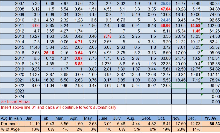
We had quite a range of rainfall totals on the island in October. On Jonesville Point we only got a little over 6 inches, but West End got over 19 inches!
We generally use Sandy Bay as our official island rain gauge and they had 12. 08 inches. That is a little less than our island average of 16.41. We are now into November which has the highest monthly average of the year at 17.4 inches. Right now the first week looks relatively dry, but we have a little system coming the middle of next week and perhaps one behind that and, as you know, rain can add up quickly. Have a great month!
Nov. 4, 2022: Good morning, Roatan! Most of us saw a light shower around nightfall last night, though for most of us it was a tenth of an inch or less, however Coral View picked up a quarter of an inch.
Today, Saturday and Sunday look mostly sunny with only a very small chance of a shower and daytime winds at 10 mph from the east and nighttime winds at 15 mph. Seas should be 2 feet through Sunday, then Monday things get calmer. Wednesday a system may come through giving us rain and westerly winds. Have a great Friday!
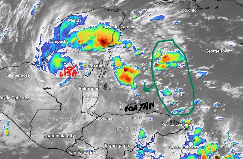
Nov. 3, 2022: Good morning, Roatan! In the end, no one saw more than an inch of rain on the island, and the west end generally saw less than half an inch. The east end generally got between half an inch and an inch between Tuesday night and Wednesday morning. North of Belize City, almost 14 inches were recorded, so we were really fortunate.
This morning, Punta Blanca on the east side has already picked up a nice shower.
On our satellite at 5:30 a.m., you can see the center of Lisa just north of the Guatemala/Mexico border. It should make it to the Bay of Campeche and not be a direct factor in our weather anymore. I have marked in green an area of rain that may give us more showers this evening and overnight into tomorrow. Winds will be from the east 5-12 mph during the day and 12-17 mph at night.
Tomorrow afternoon looks nice, but showers may return Friday night into Saturday morning. The weekend looks nice and mostly dry with moderate east winds and seas 1-2 feet. The chance of a small norther may give us westerly winds and rainier weather toward the middle of next week. Have a great Thursday!
I think we can pretty confidently say this morning there will be no hurricane for Roatan! Notice how the storm is clearly to our north this morning and the island itself is in a dry area on the much weaker side of the storm. Seas will definitely be rough, especially on the north side. We have gotten winds gusting to 29 mph on Jonesville Point and 30 mph near West End and as the storm moves away and strengthens, 35-40 mph winds are not out of the question.
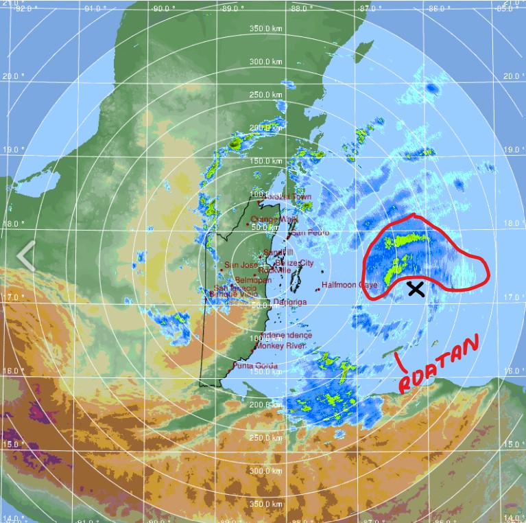
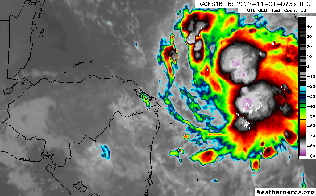
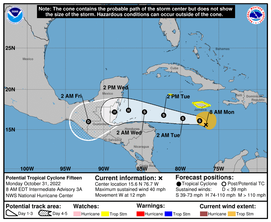
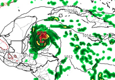
You will notice on Belize radar this morning you can see a small eye to this storm, marked with a black “x”. Almost all the rain with this storm is on the north side, away from us. There is some rain to our west which could come our way around daybreak. After that, though, there is some dry air behind the storm, which could mean our Wednesday will actually be kind of dry.
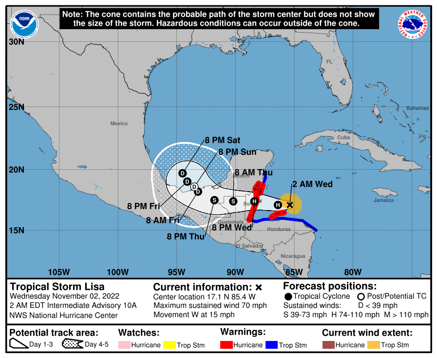
The National Hurricane Center says the storm currently has winds of 70 mph but…
The good news is the center is definitely going north of us. Winds should kick up later in the morning but I’ll be surprised if anyone on the island sees hurricane force winds. The storm itself doesn’t look well organized right now. That said things can change quickly. I’m still a little concerned that it gets its act together and creates stong southwest winds perhaps around 40 mph or higher later this morning.
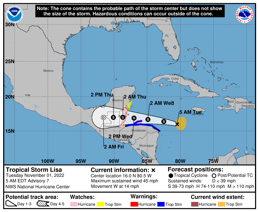
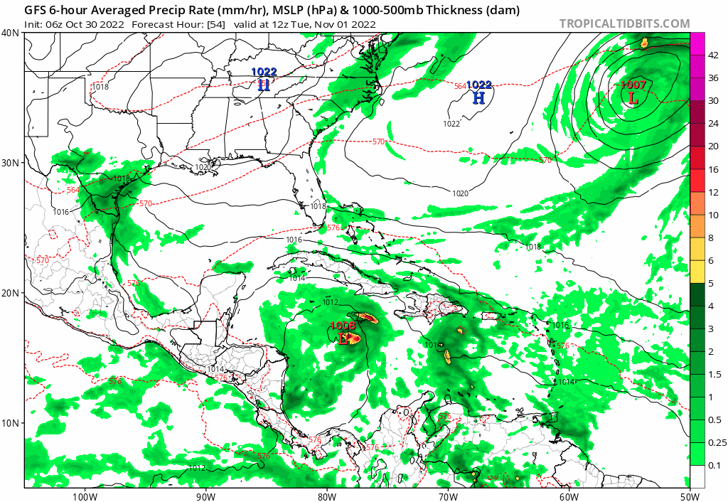
I am writing this at 4:55 a.m. and will try to update as often as possible. We start the morning with the current satellite image of Tropical Storm Lisa. The U.S. Air Force is on the way to take direct readings, but right now we have estimates based on this image. The National Hurricane Center estimates that this storm has sustained winds of 45 mph, just barely a tropical storm, but it is predicted to get stronger as the day goes along. Right now you cannot see a good center on this storm. The longer it takes to get organized, the better it is for us.
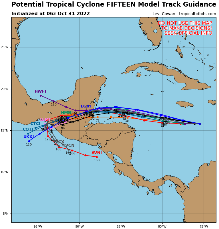
Here is the latest forecast track from the National Hurricane Center. It is forecast to go just to the north of the Bay Island and it has Guanaja very close to the center. There are two things that will determine how strong our winds are: 1. When does this storm form a well defined center (an eye)? If it forms a center before it reaches the islands and that center passes over the islands, the strongest winds will be right along the eyewall. 2. How close does this storm come to the islands? A change of a few miles makes a big difference.
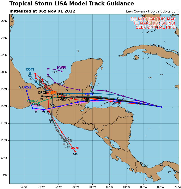
You will notice that most computer models have the storm passing to our north. The south side of tropical storms is generally weaker than the north sides. Many models are still only giving us 30 mph winds from this storm. Hurricane force winds are still a possibility; that is why we are under a Hurricane Watch, but there is also a good chance we come away from this with only strong winds in the 30-40 mph range, not much worse than our worst windy days.
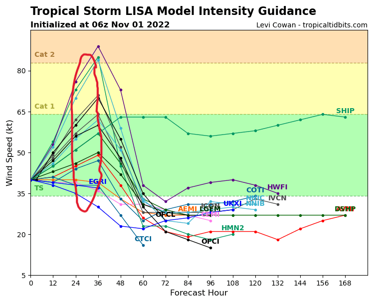
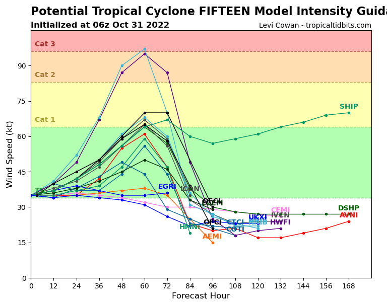
I have marked in red the computer intensity forecasts for the time period from midnight to 6 a.m. tomorrow when we should be experiencing the worst winds. A few models have the storm as a hurricane, some even going toward a Category 2 (96 mph winds) but most have it staying a tropical storm. If it stays a tropical storm as it passes north of the islands that is the best scenario for us.
Keep an eye on the strength of the storm. If it passes near us or makes landfall on the island, our worst winds will be early Wednesday morning as they switch to the southwest. That is when some minor storm surge (1-3 feet) will affect the south side of the island.
After all this passes, we still have decent rain chances Thursday and Friday with east winds 10-15 mph. Saturday afternoon looks nice and there is a chance of rain returning for Sunday.
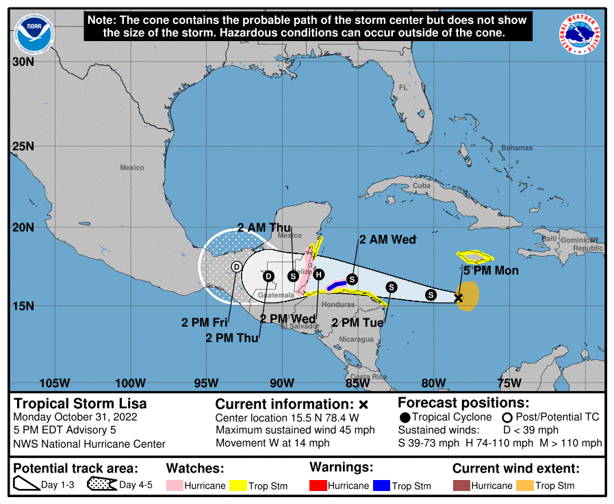
The National Hurricane Center has issued a Tropical Storm Warning for the Bay Islands. Separately the government of Honduras as issued a Hurricane Watch for the islands. We now have a 70-80 percent chance of seeing tropical storm force winds (39-73 mph). Hurricane force winds are not out of the question. The first winds should start Tuesday evening and last through Wednesday morning. The high pressure to our north has strengthened and that has pushed the forecast route a little further south. We don’t need to panic, but we need to be aware of the fact that 40 mph winds are now likely at some point and hurricane force winds around 75 mph, though unlikely, are not out of the question. If you are in a very low-lying area, be prepared for the possibility of a small storm surge in the 1-3 foot range.
Just to clarify the winds are a concern from sundown Tuesday into Wednesday around noon. Tuesday night winds will be from the northwest creating surf on the north side. Early Wednesday morning winds turn west then southwest in the 3-9 am time period. These will be the worst winds, probably 40 mph but perhaps a little worse. If we need to worry about a little surge on the south side this is the time period. Right now it doesn’t look worse and 1-3 feet but we’ll be watching it.
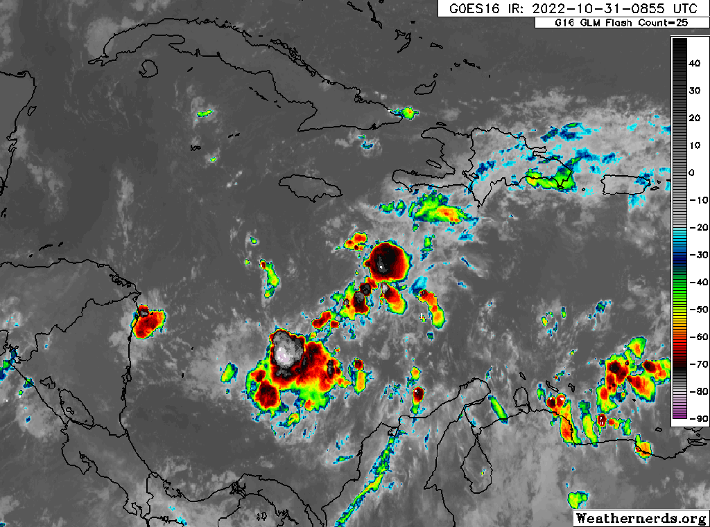
Oct. 31, 2022: Good morning, Roatan! Today should be a nice day with clear skies and calm winds and seas. Tomorrow morning should be sunny, but winds will start turning to the west and increase to around 15 mph in the afternoon with increasing clouds and the approach of what should be Tropical Storm Lisa. The center of the storm is on the northern end of the line of storms you see in this image.
Oct. 31, 2022: Good morning, Roatan! Today should be a nice day with clear skies and calm winds and seas. Tomorrow morning should be sunny, but winds will start turning to the west and increase to around 15 mph in the afternoon with increasing clouds and the approach of what should be Tropical Storm Lisa. The center of the storm is on the northern end of the line of storms you see in this image.
Most of the computer models agree that the center will go to our north, so that is a good sign.
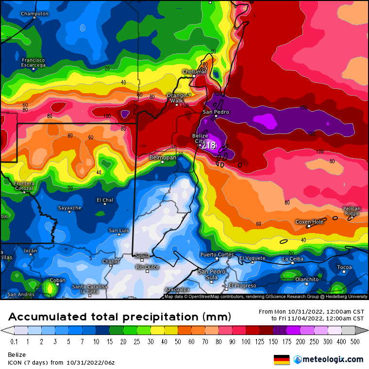
As for how much rain we will get, the track of the storm will have a lot to do with that. Notice how we are on the edge of a lot of rain (7 or 8 inches) to our north and not much rain (an inch or two, or even less) to our south. The closer the storm is to us, the more rain we will get, but generally, the south sides of storms are less windy and rainy than the north sides, and chances are good we will be on the south side.
I’m still a little concerned we could see rapid intensification. You will notice that two computer models are forecasting a high-end category 2 storm, which would mean winds near the center at 100 mph or a little more. Most models keep this as a strong tropical storm or a low-end category 1 hurricane. Though it isn’t likely, a stronger hurricane is not out of the question. Make your preparations today. Though it is likely we will only get 30-40 mph winds and moderate rain and seas around 5-6 feet, any movement to the south and intensification would put us in danger and there won’t be much time to react. After the storm passes, there is a good chance of rain on Thursday, but Friday into the weekend look nice.
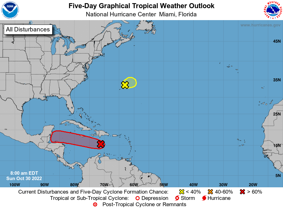
Good morning Roatan. If there are two main points this morning, they are: 1. The storm looks like it is headed toward us, probably Wednesday. 2. It is unlikely to be a strong hurricane. Most models are forecasting Tropical Storm Lisa, which would put winds between 39 and 73 mph. This is the US GFS forecast model and there is now good agreement among the various models that this is close to the track that this storm will take.
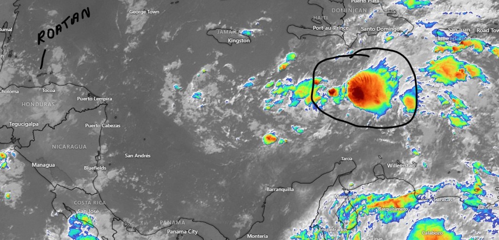
The storm is now in the eastern Caribbean, about halfway between the Dominican Republic and Venezuela. Though it isn’t yet a tropical depression, there is what clearly looks like it could be a center this morning.
As you can see from the forecast track from the National Hurricane Center, the storm is forecast to come our way, with a slight move to the south at the end. That isn’t good for us and might remind some people of how Hurricane Mitch came south over the islands in 1998, but…
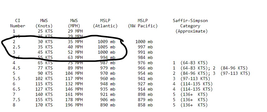
Currently the strongest forecast for this storm is the Canadian, which puts it at 999 millibars of pressure as it moves just to our north.
At 999 millibars, we would be looking at a mid-range tropical storm with peak winds around 50 mph.
Right now the wind forecast for the island is around 28 mph. That is because the storm is currently forecast to go just north of the island, and the south side of a storm is the weaker side. There are two reasons to be careful about this: 1. Forecast models have a history of underestimating storms in the western Caribbean and 2. Storm paths can easily change, and if this storm moved south right over us, we would have higher winds.
Most models have the storm as a tropical storm at 72-96 hours, which is when it is expected to pass by us. A few even have it not quite making it to tropical storm force (39 mph). Let’s hope they are right.
Oct. 30, 2022: Good morning Roatan. Yesterday morning we picked up half an inch on Jonesville Point and many locations have picked up a small shower this morning. The big winner yesterday was West End with 1.29 inches around 9:30 a.m. We’ll keep a small chance of rain around until about noon or early afternoon after which we should be mostly sunny with light winds and seas 1-2 feet. Monday and Tuesday morning look dry and fairly calm. Our tropical weather disturbance should come Wednesday, perhaps early. More on that in the tropical update.