May 6, 2023: Good morning, Bay Islands. We should be just a little calmer today than yesterday with winds 12-18 mph during the day with 2-3 foot waves and 20-25 mph and 3-4 foot waves tonight. The next few days will be very similar with dry conditions. We’re still hoping that scattered rain chances get better next weekend and for the week after that. Have a great weekend!
May 5, 2023
May 5, 2023: Good morning Bay Islands. We wake up to winds 20-25 mph and seas around 4 feet. Skies are clear and there hasn’t been much air pollution thank goodness. Today and tonight will be windy, with wind getting up to 30-35 mph tonight with seas 4-5 feet. Tomorrow will be a LITTLE calmer, with daytime winds 15-20 mph and seas 2-3 feet and nighttime winds 22-27 mph and seas at 4 feet. The first part of next week will be much the same and we will continue dry with only occasional high, dry clouds.
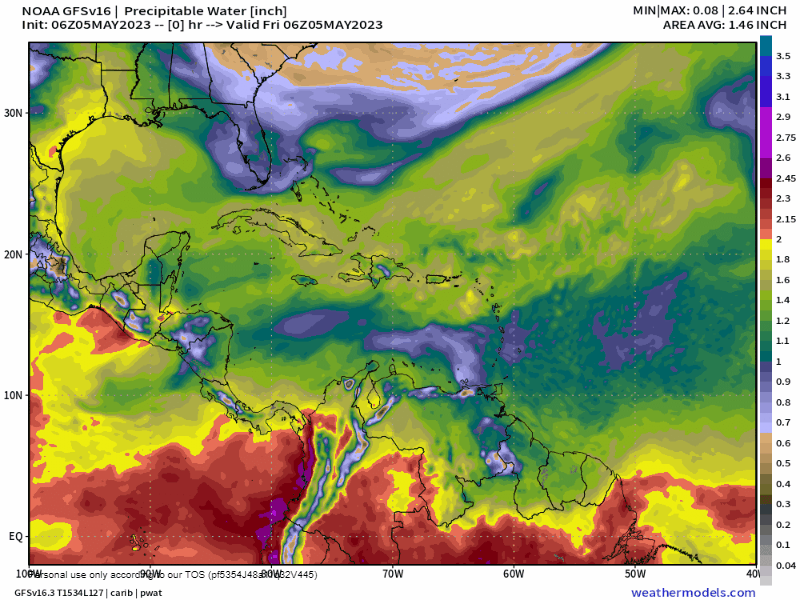
The weather map I am including today gives us a little hope. The green is dry air in the upper atmosphere, and the red is moist air, the kind that brings us scattered showers. You will see that toward the end of next week we get moist air and it stays with us into the latter part of May. If this holds true it will mean daily chances of rain in that time period. Let’s hope so. Low tide is 2:17 p.m. Have a great Friday!
May 4, 2023
May 4, 2023: Good morning Bay Islands. A big question is whether this haze is clouds or smoke. The answer is that most of the stuff above us is clouds, but those clouds are not near the surface. If you are seeing grayed out hills or ships in the distance, that is poor air quality and probably smoke.
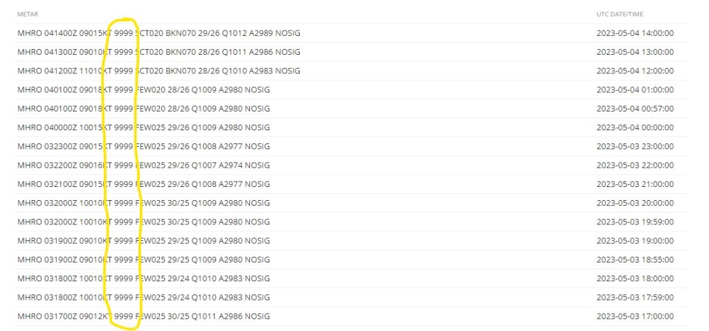
I saw a lot of that yesterday afternoon. I’m a bit confused as to why the airport is reporting 9999 meters (unlimited) visibility all day yesterday and this morning. That’s not what it seems like to me.
This morning we wake up to 15 mph winds and 3 foot waves. As the day moves along things will get even windier, until we get up to 30 mph winds tonight and 5-6 foot waves. Tomorrow will be much the same. Saturday winds will be 15-25 mph and seas at 4 feet. Aside from the smoky haze, the high clouds should clear out the next two days before coming back on Saturday.
The US GFS computer model is still wanting to give us scattered showers starting the end of next week and through that weekend, while other models are not as optimistic. We’ll keep an eye on it. Low tide is 1:38 p.m. Have a great Thursday.
April 2023 rainfall (or lack thereof)

No one got much rainfall last month. The most was 1.35 inches in West End and the least was .07 in Coral View, but lots of us got less than a tenth of an inch, including me on Jonesville Point. We will officially put .62 in the record books, from Sandy Bay’s total. Our average for April (our driest month of the year) is 1.47. We’ve been behind all of 2023, though. We are not a third of the way through the year and we’ve gotten only 13 percent of our average annual rainfall. Another way of saying that is that we normally have 21 inches through the first four months, and we’ve gotten about 11 inches. So we are about 10 inches in deficit for the year. May averages 2.63 inches, but last year we only got half an inch. There’s no rain in the forecast until the middle of the month. Let’s hope it turns out because our yards are gettting thirsty and mangos like some dryness to mature but getting a little rain at the end helps the ripen.
May 2, 2023
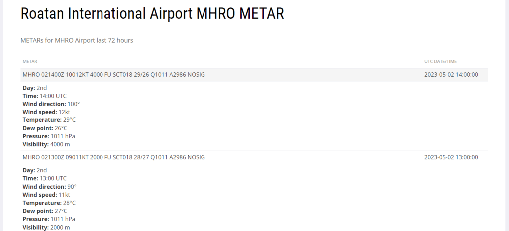
May 2, 2023: This is what I was worried about. As of 8 a.m., visibility at the airport was down to 2000 meters (just over a mile). At 9 a.m. it was back up to 4000 meters. Yesterday it was 8000 meters much of the day. When flights were being cancelled it was down to 1000 meters.
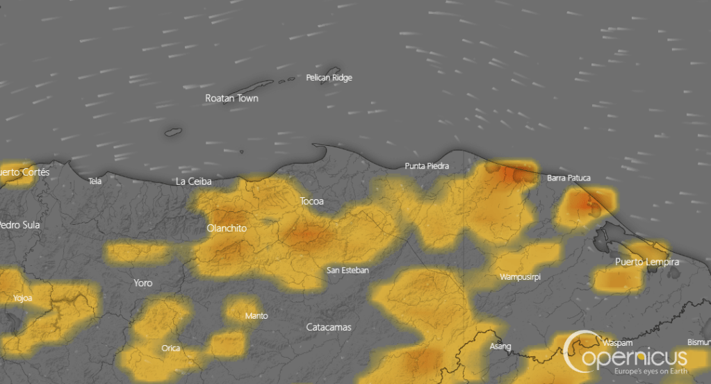
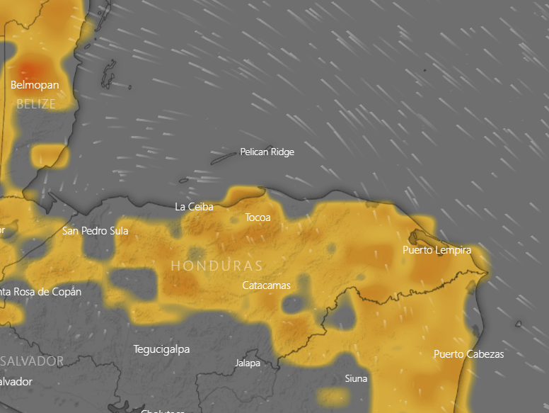
The fire map shows fewer fires than before the weekend, but still some intense fires toward the coastline of Gracias a Dios Department, to our southeast where much of our smoke comes from. Over the next few days winds will be mostly from the east, but occasionally shift to the northeast or southeast. Northeast winds are better; southeast winds are bad because they bring smoke. There is a small chance for rain on the mainland the next few days and basically no chance of rain for us. We will have varying degrees of smoke for the next few days. Today and tomorrow we will have moderate winds 10-15 mph and 3 foot seas during the day and 20-25 mph winds and 4 foot seas at night. Thursday and Friday the east winds will be even stronger, before getting back about where we are now for the weekend. We’re still hoping for some rain in a week and a half. Have a great Tuesday!
May 1, 2023
May 1, 2023: Good morning Bay Islands. No rain last night on the island and the big winner yesterday was West Bay with over half an inch. Winds got dead calm overnight and seas are 1-2 feet. We have high clouds this morning, but should stay dry. Winds will come back this afternoon and evening from the northeast at 10 mph. Tomorrow winds will turn more to the east and by nightfall should be up to 20-25 mph with seas around 3 feet. The rest of the week looks dry and breezy.
A big question is whether the smoke will return. It is hard to tell how much rain fell in northeast Honduras with poor radar coverage and no reporting stations, but my guess is not much. Unlike us, they will have small chances of rain this week, but as the wind turns back to the east watch for signs of returning smoke.
The longrange forecast is trying to give us rain chances around the middle of May. Low tides are 12:04 p.m. and 12:28 a.m. Have a great week!
April 30, 2023
April 30, 2023: Good morning Bay Islands. The good news is that visibility at the airport is 5000 meters (3 miles) this morning, much better than 1000 meters (about half a mile) yesterday. Winds are from the west at 10 mph and seas are 3-4 feet mostly on the north and west sides.
The video here shows the rain coming down out of Belize last night. Sadly, most of the rain fell between San Pedro and La Ceiba, not where we really need it, toward Trujillo and to the east of there. The reporting station in Utila seems to getting a shower at 7:45 a.m. as I am writing, giving them .14 of an inch. Locations on Roatan either got no measurable rain or .01, but we will have a chance of a shower through today. Winds will remain from the west at 15-20 mph and seas will be 3-4 feet especially north and west sides. We will have a decent chance of rain tonight with winds from the northeast at 5-10 mph and seas at 2 feet. Tuesday will be partly cloudy with a small chance of a morning shower and light winds turning back to the east. Starting Tuesday night we get strong east winds, high clouds and little to no chance of rain. Let’s hope that by then the northeast of the mainland has gotten enough rain to knock down the fires. Low tides are 11:41 a.m. and 11:57 p.m. Have a great Sunday!
April 29, 2023
April 29, 2023: Good smoky morning Bay Islands. This morning winds have calmed considerably, which doesn’t move the smoke anywhere. But we have hope starting tonight for some improvement.
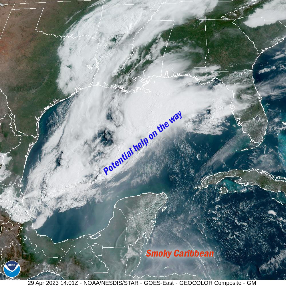
A front is sweeping through the Gulf of Mexico that should do two things. It will bring us a chance of rain, as early as tonight. Perhaps more important for the short term is that starting around midnight it will shift our winds to the west at around 20 mph. That means the wind will no longer be coming from the smoky mainland of Honduras but from less smoky Belize.
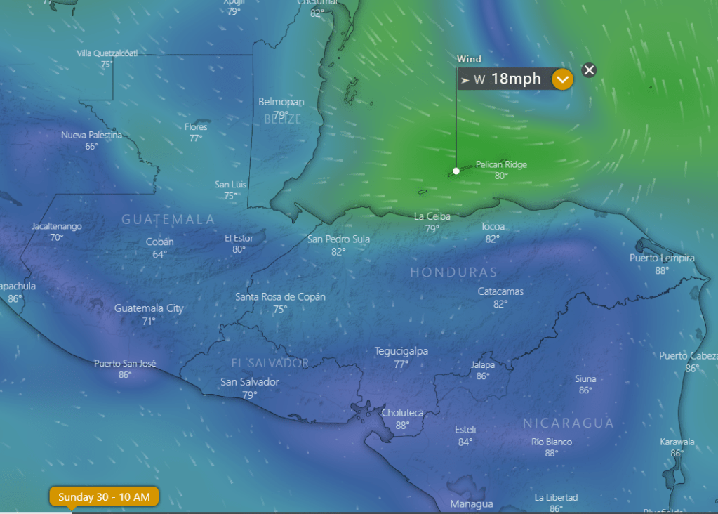
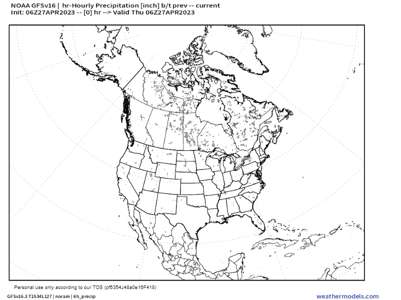
The wind forecast map here is for 10 a.m. tomorrow showing a decent breeze from the west.

The GFS is giving us a chance of rain as well starting tonight between midnight and sunrise. It’s not a lot of rain, and unfortunately it is mostly for the western half of Honduras, but the rain chances return Sunday night when they will be better for the eastern half of Honduras, the source of our smoke.
The Euro is a little less hopeful for a lot of rain, especially in the places where we need it. the northern coastal areas of eastern Honduras. If the rain doesn’t knock the flames back enough, we could be right back in the smoke starting Tuesday when the east winds come back pretty strongly and dry conditions return for the rest of the week.
In the meantime tonight and tomorrow we will have that 20 mph west wind meaning 2-3 foot waves, especially on the north and west sides of the island. Monday will be relatively calm, but what wind we have will be from the north. Let’s hope for a strong westerly breeze and good rain, especially in northeastern Honduras. Low tides are 11:12 a.m. and 11:23 p.m. Have a great weekend!
April 28, 2023
April 28, 2023: Good smoky morning Bay Islands! The question on everyone’s mind is when will all this smoke go away. The answer is perhaps we will get some relief this weekend, but it isn’t a sure thing.

On the satellite image from this morning you can see the smoke, which is low in the atmosphere, bad for breathing and landing planes. Unfortunately, this time of year we are dominated by high pressure which keep the smoke from getting to the upper levels of the atmosphere and blowing away.
This map shows the concentrations of fires on the mainland, which are mostly to our southeast, which is bad because our dominant winds come from the southeast.

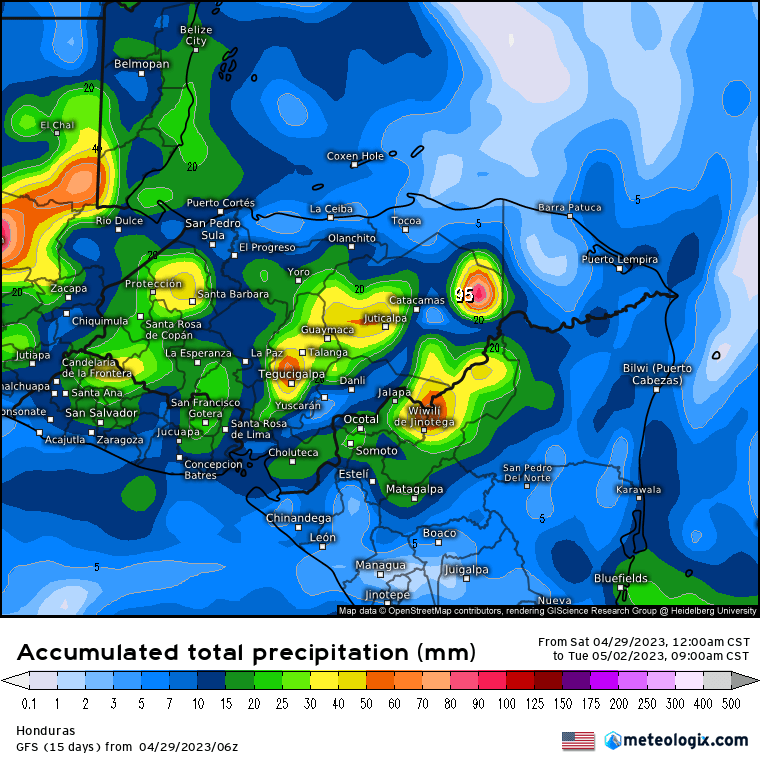
This is the Euro forecast for rainfall through Monday. This is not a good forecast for us.
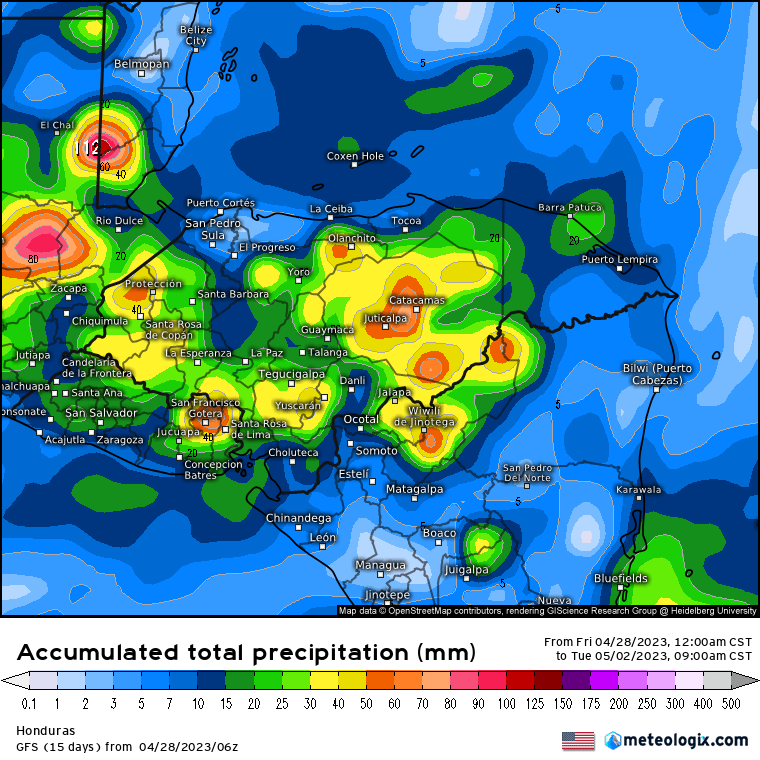
This is the GFS forecast for rainfall through Monday. Let’s hope this is more accurage. The yellows and oranges represent an inch or two of rain, especially in Colon, although we could really use it in Gracias a Dios as well. This would help with the fires if we can get this kind of rain Sunday night.
Our winds are calmer this morning and will be calmer through Monday, but what winds we will have will switch to being from the west tomorrow evening. That should give us a little relief. Winds will be fairly calm during the day through Monday, 15-20 mph at night from the west Saturday night and from the north on Sunday night. Sunday night we have a 50/50 chance of rain. Things get dry and windy again, especially starting Tuesday night. Low tides are 10:45 a.m. and 10:48 p.m. Have a great Friday!
April 27, 2023
April 27, 2023: Good morning Bay Islands. We got windy last night, up to 37 mph and seas up to 5 feet. This morning we have calmed to 15 mph and 2-3 feet. We have one more windy night before things start calming down tomorrow. Tomorrow through Monday we will have daytime winds that are fairly calm, seas 2-3 feet, and nighttime winds 15-20 mph.
We are still watching for a chance of rain Monday morning.
The forecast map here shows the storm system winding up through North America and a line of showers along a front. As you can see, we are at the very end of the front, where the rain sometimes dries up, so rain on Monday morning is not a sure thing, but I’m saying there’s a chance, and that’s better than nothing.
Low tides are 10:16 a.m. and 10:10 p.m.
