October 18, 2023

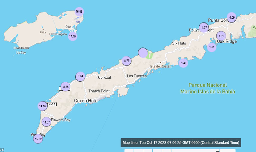
Good morning Bay Islands. Here is the rainfall we recorded yesterday …

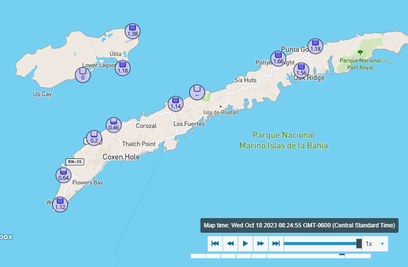
… and here is the rain between midnight and 8:30 a.m. today.

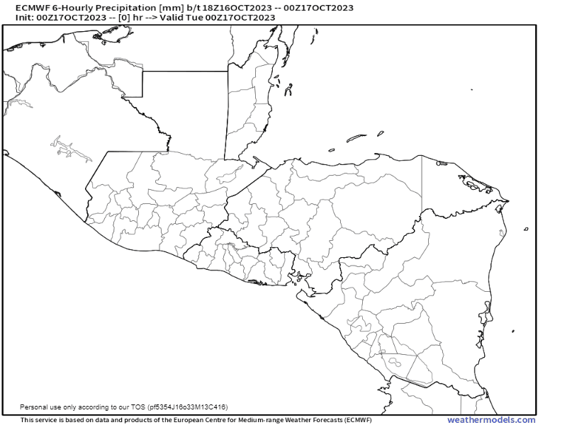
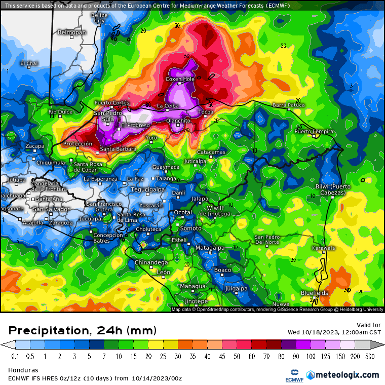
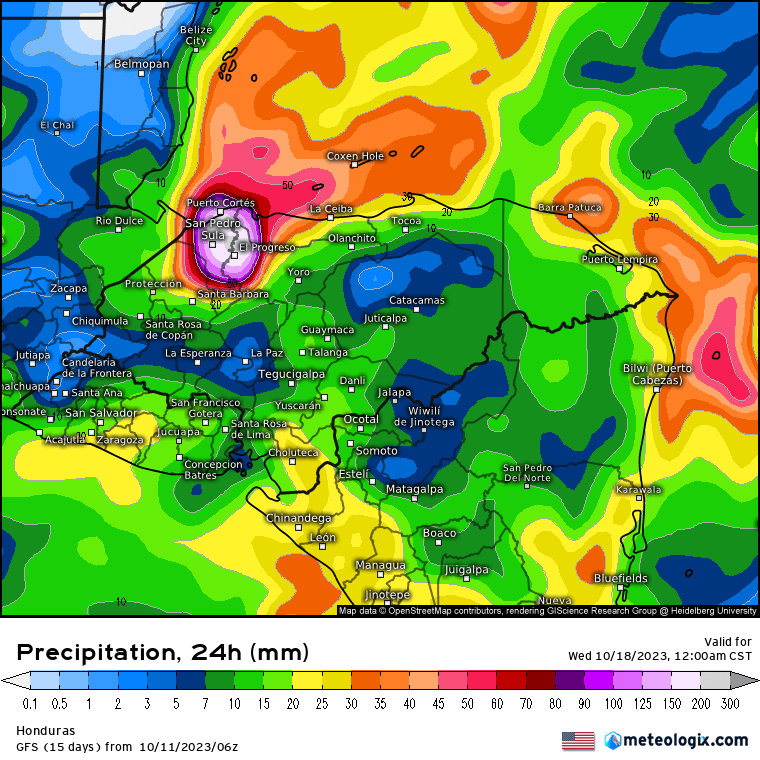
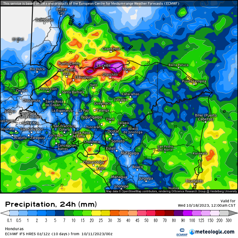
We have steady rain here on the east side at 7:40 a.m., but the bad news is there are heavy storms to our east that will be moving this way. The Euro has these storms coming right over us. If that happens we’ll have a rainfall day like we had on Monday with 10 more inches a real possibility. The GFS has it moving more to the south, which would lessen our rain, but I still expect this to be a rainy and perhaps stormy day. North winds this morning are 15 mph from the north with 4 foot seas on the north side. Northeast winds as we get into the evening will pick up to 20-25 mph and seas to 6-7 feet, not a good day to be on the water.

Tomorrow morning still looks rainy. Rain should decrease in the afternoon tomorrow but there will still be scattered showers. North winds will also decrease to 10 mph by afternoon tomorrow and seas to 3 feet. Friday and Saturday we will have north winds 10 mph and seas at 2 feet, with about a 40 percent chance of showers and partly sunny skies. Sunday looks like a nicer day and Monday we get another norther, though not as strong as this one.
Watch for flash floods. Stay safe!

October 17, 2023

Good morning Bay Islands. Here are the rainfall totals for yesterday and today until 7a.m. The further west (and south) you go, the higher the total. Truly impressive rainfall for Utila and the west side.

Looks like it rained so much that kids don’t have to go to school today.

The buoys are reporting north winds 15 mph and seas at 4-6 feet on the north side. Seas will remain around 4 feet on the north side today and tomorrow.

In the forecast rainfall map, you can see we have good chances of rain to continue today and tomorrow, but the heaviest rainfall should shift eastward. That’s a good thing because the east side and Guanaja got MUCH less rain than the west side and Utila.
Computer rainfall projections are imperfect. I guarantee, no one was forecasting 15 inches of rain yesterday. Right now the computers are forecasting about 2 more inches today and 4 inches for Wednesday. The rainfall should become less Thursday, especially in the afternoon and we will have lower rain chances and some peeks of sunshine into the weekend, but we will still have a 40 percent chance of scattered showers each of those days.
A weaker norther comes in on Monday increasing our rain chances and giving us a breeze from the northeast. Have a great day, keep us informed of what you see and stay safe!
https://www.patreon.com/roatanweather

October 16, 2023

Good morning Bay Islands. I did a video forecast to discuss our norther.

The front is just to our north. Clouds and rain and winds will increase through the day. Windiest and rainiest days are tomorrow and Wednesday. Less rain Thursday into the weekend, though chances of seeing some rain those days are still pretty good. Have fun with the fresher and wetter weather!

One thing I forgot to mention in the video is that this norther should finally cool down our seas, which are still very close to 90 degrees and causing coral bleaching. This has been our worst coral bleaching year, perhaps ever. Let’s hope it ends soon.
https://www.patreon.com/roatanweather

October 15, 2023

Satellite at 7 a.m.

Good morning Bay Islands. We wake up this morning to east winds around 10 mph and seas at 2 feet both north and south sides. Those winds and seas should get calmer as the day goes along. We can clearly see the norther (cold front, frente frio) to our north, just south of Miami and extending west to just north of Yucatan.

Satellite at 7 a.m.

On the closeup satellite we can see a small area of clouds south of Flowers Bay. It is possible someone might see a shower this morning, but the chances are small. Rain chances get better as we go into the evening. Tomorrow, the winds turn around to the north. Rain chances are good for Monday, around 60 percent, and winds will by Monday evening will be from the north 15-20 mph. Monday night into Tuesday morning we will have our strongest north winds, around 20 mph and seas on the north side 4-5 feet. Tuesday and Wednesday should be quite rainy and fresh, and Thursday rain should decrease a little, down to a 40 percent chance.

Here are three estimates for rainfall through Thursday. On the left is the US GFS, in the middle the Euro, on the right is the ICON from Germany. They are all very similar in giving us 3-4 inches of rain, but you will notice the farther north you go, the less rain you get. That is because a lot of the rain is created because the north winds hit the mountain of the mainland and are pushed up into rain clouds. We could very easily get 1-2 inches this week, but we could also very easily get 5-6 inches. (Remember, 25 mm = 1 inch).

I have seen in my four and a half years on the island that sometimes these northers don’t produce as much rain as forecast, so I thought I would try to find a model that gave me reason to believe we might be overestimating the rainfall. This is the only one I could find. It is the British model and it is not generally as reliable as the three models above. It forecasts two inches of rain for us, but notice how the rainfall drops off to almost nothing to our north. In this scenario we would get cooler temps and north winds but less rain, perhaps 1-2 inches. It is just a reminder that in weather forecasting, nothing is certain. Be prepared for everything. Have a great Sunday!

October 14, 2023

Satellite at 7 a.m.

Oct. 14, 2023: Good morning Bay Islands. We have clear skies across our islands and good viewing weather for our solar eclipse, which will start around 10 a.m., peak darkness will come at 11:40 and end at 1:30 p.m.

Peak darkness will last just over four minutes from about 11:38 to 11:42. We are mostly clear, but you never know when a stray cloud will get in your way. Remember that unless you have certified glasses or lenses, no one should look directly at the sun. Various locations are hosting gatherings. If your business is, feel free to post in the comments section on our Facebook page.

Today will be the last day with a very low chance of rain. Tomorrow we will have a few scattered showers around, but we shouldn’t have a whole lot of rain. Winds and seas will be fairly calm. Our winds will start to turn around to the north on Monday and clouds and rain chances should increase through the day Monday. Our rainiest days should be Tuesday and Wednesday.

The US GFS computer rainfall forecast for Tuesday is forecasting about an inch and a half for Roatan and Guanaja, but notice how the closer you get to the coast, the higher the rain total gets. That puts Utila in an area with 4 to 6 inches.

The Euro computer rainfall forecast for Tuesday gives the west side of Roatan just under 4 inches. Both forecasts look very similar for the day on Wednesday. Rain totals are forecast to be a bit lower Thursday into the weekend, but scattered showers are still in the forecast for those days.
In my experience, rain forecasts for northers tend to be a little exaggerated, but we will definitely get good rains this week. Winds Monday evening through Wednesday morning will be 15-20 mph from the north giving us 4 foot seas on the north side. There will be periods of heavy downpours when we might pick up an inch in 15-20 minutes. That kind of rain can lead to flooding, especially in areas where construction has changed the drainage pattern in unpredictable ways over our dry year so far. Be weather aware this week and enjoy the cooler temperatures!

October 13, 2023

Good morning Bay Islands. We wake up to 3 foot seas on the south side and 2 foot seas on the north side, higher than we’ve had in quite awhile. This evening we will have east winds around 20 mph and seas around 4 feet on the southside, 2-3 feet on the northside.
Today and tomorrow look dry, but those are the last dry days we’ll have for awhile.

That’s good for our near-total solar eclipse tomorrow. Remember not to look directly at the sun. That ring of fire still has harmful rays that can damage your eyes.

Sunday will be a day of increasing clouds and scattered showers. Winds and seas will be quite calm.
Monday winds start to turn to the north and we will have north winds 15-20 mph and seas on the north side around 4 feet Monday evening through much of the day on Tuesday.
Monday and Tuesday look quite rainy. Wednesday may have less rain, but Thursday and Friday morning look rainy as well. We may get a little break next weekend, then another norther is coming in Sunday night or Monday morning the 22nd or 23rd. Have a great Friday and make plans for where you’re going to take in Saturday’s eclipse.

October 12, 2023

Oct. 12, 2023: Good morning Bay Islands. This morning we are a bit windier at 10-15 mph and seas are near 3 feet on the south side, 2 feet on the north side. We will continue to have seas 2-3 feet through Saturday. Sunday looks like a calm day as we wait for the cold front (norther).
Rain chances remain low through Saturday. We may be dealing with some high clouds, but chances are good that we will get to see our near total solar eclipse Saturday morning.
There’s a bit better rain chance on Sunday, perhaps 30 percent. As we go through the day on Monday we’ll see winds start to turn around to the northwest and clouds and rain increase through the day. Tuesday still looks like the rainiest day. This week our low temperatures have been in the mid 80s and highs around 90 or 91. Starting Tuesday we’re looking at lows in the mid 70s and highs around 83. That will be a big difference.
Some of the computer models are showing rain sticking around through Friday and perhaps longer. Let’s hope so. We definitly need it.

October 11, 2023

Good morning Bay Islands. We wake up to mostly clear skies and seas 1-2 feet. We will stay mostly dry through Saturday, but our winds, especially in the evenings, will pick up to 15-20 mph from the east tonight and tomorrow night and 20-25 mph on Saturday night. Sunday we will start to see our weather change as our norther (cold front) approaches. We will have scattered showers Sunday, more widespread showers Monday and Tuesday and Wednesday could be days with very heavy rain and a cool north breeze.
I have two rainfall maps for predicted rain on Tuesday.

The US GFS has most of the rain to our west, but still gives us an inch and a half on Tuesday.

The Euro has a more typical setup for a norther, where the winds from the north run into the mountains on the coast, giving La Ceiba the heaviest rain and less rain the farther north you go from the coast. Most models give us 2-4 inches before the rain decreases next Thursday, but there is a chance some areas get more — much more. Have a great Wednesday!

October 10, 2023

Good morning Bay Islands. We have some clouds and a few thundershowers to the east of Guanaja. Those are weakening as they move west. Guanaja and perhaps even east Roatan will see some clouds over the next few hours and perhaps a small shower or two, but nothing major. Our forecast continues to be mostly sunny and hot for this week. We have 2 foot seas and east winds 10-15 mph this morning. We’re going to see winds and seas pick up as we go through the week, 2-3 feet tomorrow, 3-4 feet Thursday and Friday. Winds especially in the evenings will get up around 20 mph toward the end of the week.

Lots of folks have been asking about the weather for our near-total solar eclipse. Right now I’d say it looks pretty good. We should have some high clouds in advance of our cold front next week, but the cold front itself will still be to our north, so we should have partly cloudy to mostly sunny skies. Get ready, because it will be our last solar eclipse this good until Dec. 6, 2067.

The big story next week is the norther that is on the way. Scattered showers will increase as it approaches Sunday evening, Monday and Tuesday. Right now Wednesday and Thursday of next week look like days of heavy rain.

This will bring great relief from the heat. This is a heat index (the temperature our body feels) map for this week and next. Notice the light brown we are surrounded with this week? Those are heat indexes well over 100 degrees (38-40C). When the front gets here starting the beginning of next week, our heat indexes go down to red (80s) and orange (70sF, around 24C). It will be a noticeable cooldown. Have a great Tuesday!

October 9, 2023

Satellite at 7 a.m.

Good morning Bay Islands. At 6:50 a.m. we have some storms well to the east of Guanaja moving slowly toward the west. If they can hold together they might reach Guanaja around 9 a.m. Otherwise most of us are mostly sunny.
We start out with mild winds and seas around 1 foot, but this week will not be flat calm like last week. This evening winds will get up 10-15 mph and seas to 2 feet. This week most mornings will be fairly calm, but each evening winds and seas will pick up a bit, to 2 feet early in the week and to 3 or 4 feet later in the week.
We are watching our first norther (cold front) of the rainy season that will cause rain to increase starting next Sunday and may actually bring us north winds and heavy rains a week from Wednesday. Have a great week!