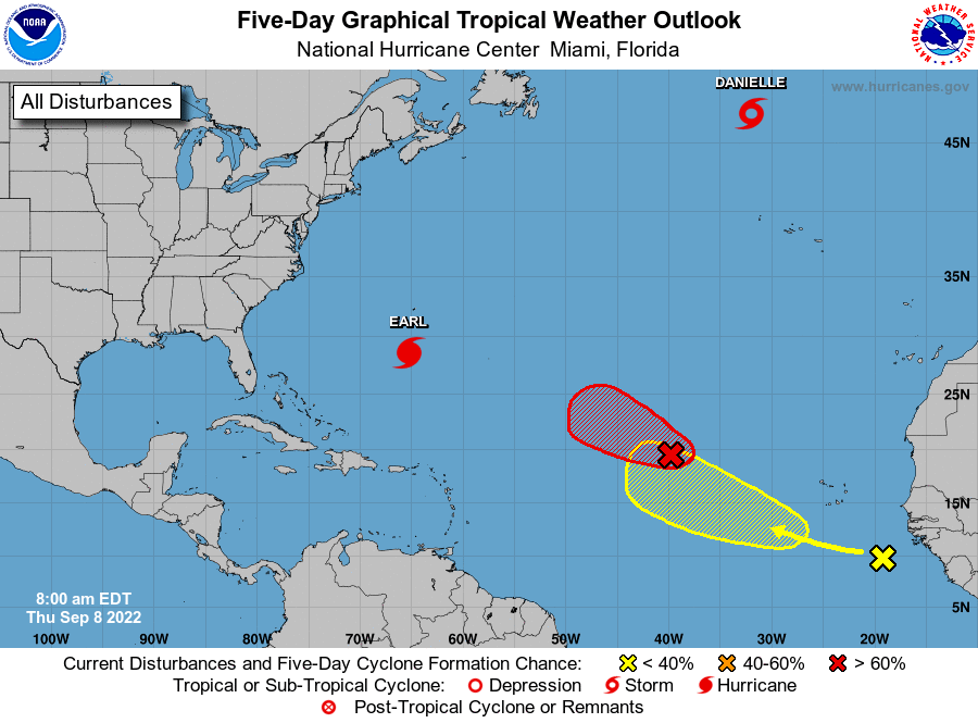
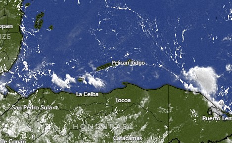
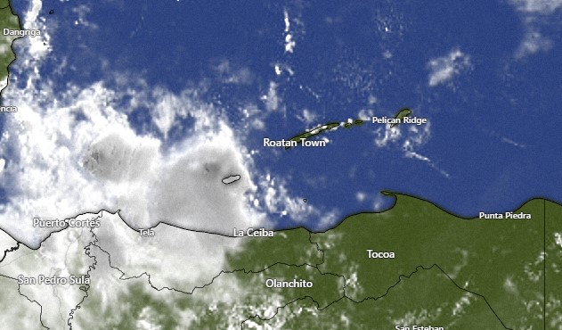
Tropical update for Aug. 25, 2022

Tropical update for Aug. 25, 2022: Well here we go. We have a National Hurricane Center forecast map that puts a tropical system in our neighborhood. But you will notice that the color is yellow, which means that there is only a 20 percent chance of tropical development over the next five days. Most of the current models either do nothing with this system or develop it as a tropical system after it passes north of here. In any case, it should bring some deep moisture and increased rain chances our way midweek next week.

Aug. 25, 2022

Satellite image from 8 a.m. today.

Aug. 25, 2022: Good morning, Roatan! No rain recorded on the island yesterday or this morning. This morning there are some clouds to our east, but as you can see on this satellite image from around 8 a.m., the clouds are diminishing as the morning goes along, which often happens with our overnight clouds and rain. We will look for partly cloudy skies today and perhaps a passing shower and winds 12-17 mph and seas 2-3 feet (.6 to 1 meter). Tonight we have a decent chance of seeing some rain.

Tomorrow winds should be fairly calm and seas 1-2 feet (.3 to .6 meters). Rain chances will be low.

This weekend winds come back to the 15 mph range with 2 to 3 foot seas. Rain chances will be low and mostly on Saturday night.

A tropical wave has a chance of giving us some rain toward the middle of next week. More on that in the tropical update.

Aug. 24, 2022

Aug. 24, 2022: Good morning, Roatan! Today is definitely a bit windier than yesterday, with 15 mph east winds and 2-3 foot seas (.6 to 1 meter) on the southside.

Today we’ll keep those 15 mph winds through the day and a good chance of a shower, especially toward evening.

Thursday and especially Friday look like relatively calm days with low chances of rain. The weekend looks nice as well, perhaps a bit windier on Sunday.

I want to make mention of the latest forecast from the National Hurricane Center. The disturbance I first mentioned yesterday is moving a little south of the forecast and a little more of concern for us. Right now most models show it heading toward Jamaica and Cuba as a weak storm and strengthening in the Gulf of Mexico, but at this point anything could happen. We’ll keep an eye on it. We’re about a week out from it being in the Western or Northern Caribbean. Have a great Wednesday!

Aug. 23, 2022

Aug. 23, 2022: Good morning, Roatan! Those stray showers got a few of us really wet, some of us a little wet and the rest of us dry if you don’t count the sweat. One rain bucket in Sandy Bay got .8 of an inch but another bucket in Sandy Bay got less than an inch. Coral View got half an inch and Politilly less than a tenth. Camp Bay picked up .04 yesterday and .11 about 4 a.m. today. Here on Jonesville Point and rain gauges in West Bay and West End recorded no rain the last 24 hours.

Today will be continued calm and hot, with seas right around 1 foot or less. Rain chances will be low, but there will still be the chance of a passing shower.

Tomorrow will be a little windier with east winds 10-15 mph and seas at 2 feet. Rain chances will be better, especially tomorrow night.

Thursday winds will be 7-15 mph and seas 1-2 feet. Rain chances will again be pretty good Thursday night.

Friday and Saturday winds should be fairly calm again. Scattered showers will continue to be mostly at night. Have a great Tuesday!

Aug. 22, 2022

Aug. 22, 2022: Good morning, Roatan! If you like the heat, this week will be for you. As I’ve often said, the temperature on the island doesn’t change much. What makes it hot is calm winds and few clouds. This week we’ll have both.

Today and tomorrow winds will be light and variable with seas at 1 foot (.3 meters). There are some cumulus clouds around, so I can’t rule out a stray shower, but very few of us will see any rain the next two days.

Wednesday and Thursday the winds pick up a bit to 12-17 mph and seas to 2 feet (.6 meters). If you’re looking for rain, best chances are Wednesday night, Thursday night and Friday night. Those nights will have a 40 percent chance of seeing a shower. Have a great week!

Aug. 21, 2022

Aug. 21, 2022: Good morning Roatan. We got a lot of thunder and lightning last night and only a little rain. Most of us only got around a quarter of an inch or less, though French Harbor got around three quarters of an inch.

At 7 a.m. there is a small area of clouds to our east that will bring us some early partly cloudy skies and perhaps a sprinkle somewhere, but for most of the day we should be sunny. Winds should be from the east 10-15 mph and seas 1-2 feet (.3 to .6 meters). Tomorrow there is a chance of a morning shower, but the day should be gorgeous overall with calm winds and 1 foot seas. Those calmer conditions should continue for most of the week, with chances of running into a scattered shower each day, especially in the early morning or late evening. Have a great Sunday!

Aug. 20, 2022

Aug. 20, 2022: Good morning, Roatan! We’re starting to get into the most active season for tropical weather and the long range forecasts indicate some action in the Atlantic, but nothing that threatens us in the foreseeable future.

Our weather will remain pretty boring, with east winds 15-20 mph and seas 2-3 feet (.6 to 1 meter). Rain chances go up a bit at night, but only a 20 percent chance tonight and maybe a 30 percent chance tomorrow night. Right now the rain chance looks like it might go up a little on Thursday. Have a great weekend!

Aug 19, 2022

Aug. 19, 2022: Good morning, Roatan! We had a dry day yesterday and will probably have another one today. Even the nighttime rain chances are pretty low. We’ll have winds around 15 mph during the day and 20 mph at night and seas at 3 feet (1 meter). Every day should pretty much be the same, except that Monday and Tuesday winds look to be a bit calmer. Have a great Friday!

Aug. 18, 2022

Satellite image from 7 a.m. today.

Aug. 18, 2022: Good morning Roatan! The storm we spoke of yesterday went completely around us to the north and is now right on the coast of Belize and Yucatan. The NHS gives it a 30 percent chance of becoming a tropical storm when it emerges in the Gulf of Mexico. Here on the east end three locations got .02 of an inch of rain about 5 p.m. yesterday while Mud Hole on the west side also reported .02.

We’ll have partly cloudy skies today and we can’t rule out a stray shower, but if we get one it shouldn’t last long. Winds should die down as the day goes on.

Friday winds pick back up to 15-20 mph and seas 2-3 feet (.6 to 1 meter).

It looks like we are in a mostly dry period with partly cloudy to sunny days and small chances of rain overnight for the end of this week into next week. Have a great Thursday.

Aug. 17, 2022

The satellite image from 6:30 a.m.

Aug. 17, 2022: Good morning, Roatan! Here on the east side we picked up some rain just before midnight. Punta Blanca got .7 of an inch and Politilly got .3. Coral View got .06 midisland. Mud Hole got a tenth of an inch and Sandy Bay got .02. On the far west side, West Bay and West End got none.

The center of the low pressure system is now directly south of us where the yellow X is on the National Hurricane Center map, but the rain is north and east of us and some of the models say the rain may miss us altogether. We’ll still say we have a 40 percent chance of rain today and 60 percent chance tonight. Winds will be east/northeast at 15-20 mph and seas at 3 feet (1 meter).

Tomorrow should be a calm day with light and variable winds and seas 1-2 feet. Any rain we get should be early in the morning.

Winds pick up to 15 mph on Friday and we begin a cycle of dry days and small chances of rain overnight. Have a great Wednesday!