Dec. 23, 2022

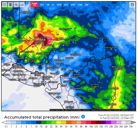
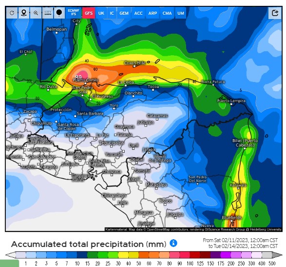
Dec. 23, 2022: Good morning, Roatan. Trying to forecast what the weather will be in a few days is difficult. But guess what? Knowing what the weather is right now is also difficult. Our current cold front illustrates that point. It is important to know how strong it is right now to know how strong it might be when (and if) it reaches us. And the fact is we don’t know exactly how strong it is right now. To illustrate, I am posting the current wind conditions from three different weather models:

The GFS
The Euro
And the ICON from Germany

Notice how at the same location in the Gulf of Mexico, there is a 10 mph difference in how strong these models believe the winds is RIGHT NOW! That has big implications for how strong the winds will be when they get here. As you probably know, cold front weaken the further south they go. That is why it is never much below 65 (18C) degrees here. Notice how big a difference that makes in our winds when the front arrives Monday morning.

Note that the GFS has the front basically stalling to our north on Monday morning and bringing us only wind gusts of 10 mph, really a pretty calm day. There is some wind to our north which would probably give the north side seas of 2-3 feet (.6-1 meters), but definitely nothing out of the ordinary.

The Euro shows the front stalling just barely to our north, which brings a little gustier winds here at 17 mph, but also brings the winds closer, giving the north side heavier seas, probably around 5 feet (1.6 meters) if this were to happen.

The ICON gets the cold front all the way here, with gusts near 30 mph. This would probably also mean much cooler temperatures and heavier rain for us, if this were to happen.

So there you have three scenarios. The GFS and the Euro are generally the most reliable models and they have been showing the front weakening more, so if I had to lean one way, I’d say this norther will probably not be as bad as we thought it might be. I’ll do the best I can to post a forecast in the next posting. 

Dec. 22, 2022

Dec. 22, 2022: Good morning, Roatan! Many of us had a shower yesterday around 8 a.m. that gave us a tenth to a quarter of an inch of rain.
Enjoy today and tomorrow, because after that the weather gets a LOT stormier.
Today and tomorrow we will have sunny skies, east winds 5-10 mph and seas about 2 feet.
Christmas Eve and Christmas Day there will be a good chance of rain and even thunderstorms, especially Saturday night into Sunday morning. Winds should be fairly mild, but on Sunday they will be beginning to come out of the north.

Saturday seas should be 2-3 feet, but less as you go toward La Ceiba.

Sunday seas will be 3-4 feet, not so much because of winds but because of swell coming out of the north.

Monday and Tuesday will be days when we should see some strong north winds and high seas, especially on the north side, around 5-6 feet and 4 foot seas all the way to La Ceiba.

Many of the models are keeping us in the rain all the way into Thursday, when things will get better for New Year’s weekend (though we will probably have some pretty strong easterly trade winds that weekend.)

Dec. 21, 2022

Dec. 21, 2022: Good morning, Roatan! We stayed dry last night and this morning we have some passing clouds, and a small chance of a passing shower this morning. Today, Thursday and Friday will be mostly sunny with east winds about 5-10 mph and seas 1-2 feet and overnights we will have a small chance of a shower and winds around 15 mph with seas 2-3 feet.

Friday night into the weekend our rain chances go up, but the models are holding back the strong north winds until sometime Monday, Tuesday or even possibly Wednesday (especially in the Euro forecast). Saturday and especially Sunday winds should be fairly moderate except in squalls, but especially Sunday there should be a little swell, which are waves caused by winds further away. That should give the north side 2-3 foot sea Sunday. There is still a good chance we will be dealing with some heavy seas Sunday night into Monday and Tuesday, especially on the north side. Through the entire period Saturday through Tuesday, rainfall totals should be in the 3-4 inch range with a few locally higher amounts. Have a great Wednesday!

Dec. 20, 2022

Dec. 20, 2022: Good morning, Roatan! Last night, especially after midnight we got some decent rain. We got a little over half an inch here in Jonesville Point and most locations got between a quarter and half an inch. We have a few clouds this morning and the possibility of a shoewer, but we should be mostly dry today. Winds will be out of the east at 10-15 mph and seas will calm a bit from 3 feet (1 meter) this morning to around 2 feet (.6 meters).

Wednesday, Thursday and Friday should be nice days with moderate winds at 10 mph, seas 1-2 feet (.3-.6 meters) and a few showers, mostly at night or in the early morning.

Friday night into Saturday we will start to see our weather change, with winds beginning to come from the northeast and a better chance of rain. It is still unclear when the highest winds or heaviest rain will be, but the period from Saturday through Tuesday will be potentially stormy, and cooler temperatures will be here especially Monday and Tuesday with some upper 60s (19 or 20 celsius) possible. Get out your jacket!

Dec. 19, 2022

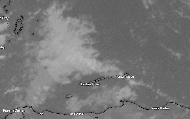
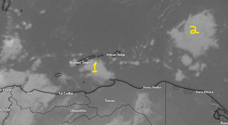
Satellite image at 7:30 a.m.

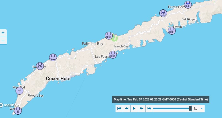
Dec. 19, 2022: A few of us got a shower in the madrugada (I love that word. There really isn’t a similar word in English to refer to the period between midnight and sunrise.) .01 in West Bay, .10 in Politilly and .02 of an inch here in Jonesville Point. We wake up to east winds around 15 mph and 3 foot seas. On satellite we see a few clouds that should pass between 7 and 9 a.m. and one shower north of the island’s east side, so we can’t rule out a morning shower, but we will stay mostly dry, with windy conditions and seas around 3 feet. Those conditions also apply to La Ceiba so if you’re going on the yacht today, take your Dramamine.

Winds will be brisk tonight before midnight, up to around 25 mph, but should start calming around midnight and into tomorrow to around 10 mph, especially on the east side and toward Utila and La Ceiba. This week will be fairly dry through the day Friday. Any rain showers we get should be mostly light and mostly at night or in the early morning.

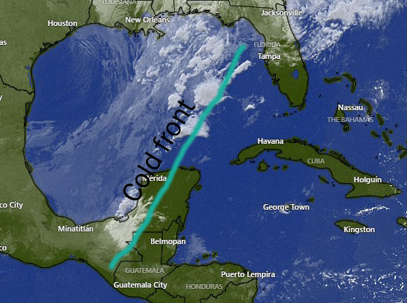
There is still some disagreement as to when our cold front will arrive, but sometime between Saturday and Tuesday we will have a day with strong north winds and rough seas. In any case Sunday through next Tuesday look pretty rainy and cool. I’m going to put together a video to talk about the possible scenarios with this norther. Have a great day!

Dec. 18, 2022

Dec. 18, 2022: Good morning, Roatan! We’ve had another dry 24 hours, though Sandy Bay and a couple of other locations picked up a small shower yesterday afternoon.

We have a few clouds and even a few showers to the west of Utila this morning, but those should decrease as the day goes on and we should remain dry, with easterly breezes 15 mph and seas 2-3 feet (.6-1 meter).

Tonight should be mostly fair, but we have about a 40 percent chance of rain tomorrow morning, especially around dawn.

Tomorrow will be even windier than today, with winds 15-20 mph, getting 25 mph Monday night, and seas 3-4 feet (1-1.3 meters). Those choppy seas extend to our south, so if you’re headed to Ceiba take your Dramamine.

Winds should be a bit lighter on Tuesday at 10-15 mph and seas at 2-3 feet. There is a small chance of a morning shower Tuesday.

Wednesday and Thursday look calmer with small chances of morning showers each day.

Friday into the holiday weekend we are expecting rainy and quite possibly windy conditions as the cold front that will bring frigid conditions to North America finally reaches here. The exact timing is still uncertain, but most models have the cold front reaching here is two waves, the first on Christmas Eve with moderate winds and the second on Tuesday the 27th, with strong northerly winds and heavy rains. It’s still a little early to know for sure. We’ll keep an eye on it.

Dec. 17, 2022

Dec. 17, 2022: Good morning, Roatan! As you can see in the 6:45 a.m. satellite, we have quite a bit of thin clouds moving in from the east which will give us partly to mostly cloudy skies today. We can’t rule out a small shower from any of these clouds, but our chances are only around 30 percent and any rain should be light. Winds should get quite calm, especially on the west side and seas will be 2 feet (.6 meters) east and 1 foot (.3 meters) west and in Utila.

Overnight winds will pick up to around 20 mph and seas at 3 feet (1 meter).

Tomorrow should be a nice day with 15 mph winds and seas 2-3 feet.

Sunday night into Monday morning we will have a 40 percent chance of a shower. Monday will be breezy, with 15 mph winds and 3 foot seas. Tuesday and Wednesday look a little calmer, but there will be about a 40 percent chance of a shower Monday through Wednesday.

The models are still not certain about a cold front for Friday. The two main model (U.S. and Euro) show it stalling just to our north will some others (the German ICON) show it bringing us true norther conditions Friday into Saturday. We will keep an eye on it. Have a great weekend.

Dec. 16, 2022

Dec. 16, 2022: Good morning, Roatan! We wake up with winds around 15 mph and seas around 3 feet (1 meter). Those winds and seas should calm through the day to 5-10 mph and 2 foot seas (.6 meters).

Tonight into tomorrow morning the rain chance is very low with winds 10-15 mph on the east side and 5-10 mph on the west side and Utila and seas still around 2 feet.

Tomorrow will again be nice, with southeast winds 7-12 mph and seas at 2 feet.

Sunday we will have about a 30 percent chance of a shower with east winds 10-15 mph.

Sunday night into Monday morning we will have about a 50 percent chance of seeing a shower and Monday looks to be one of our windier days, with 20 mph winds and seas 3-4 feet (1-1.3 meters). We may start feeling the effects of the next norther on next Friday with rain and north winds, though we can’t say right now exactly how strong it will be. Have a great Friday!

Dec. 15, 2022

Dec. 15, 2022: Good morning, Roatan! We wake up to clear skies and winds from the east. Today those winds should calm quite a bit by midday and seas should calm to 2 feet (.6 meters) and perhaps even 1 foot (.3 meters) on the western end of Roatan and in Utila. We have a few clouds to our east which should give us a few clouds, but any rain is unlikely.

Tomorrow we will continue with light and variable winds and seas around 2 feet with dry conditions.

Friday night into Saturday there will be a small chance of rain, but during the day Saturday we should be dry with morning winds and a calmer afternoon.

Saturday night into Sunday morning we will have a little better chance of rain. Rain is likely around the island Sunday night into Monday morning.

You may have heard about the arctic outbreak that is forecast for North America for the holiday weekend. Chances are looking good for that to reach here, giving us norther conditions, with north winds, cool temperatures and rain, possibly right on Christmas Eve and Christmas Day, though I’d say the chance of snow is pretty low 😉 Have a great Thursday.