August 17, 2023

Radar at 7:40 a.m.

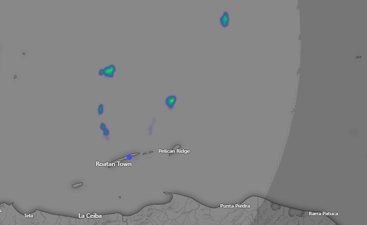
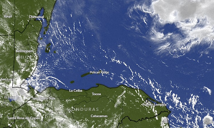
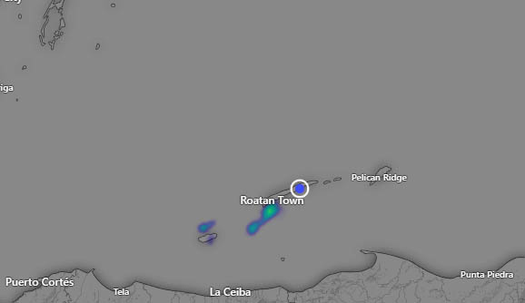
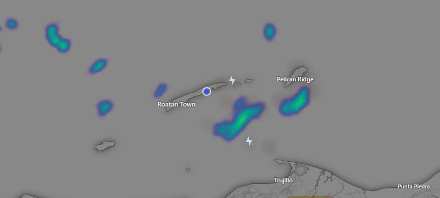
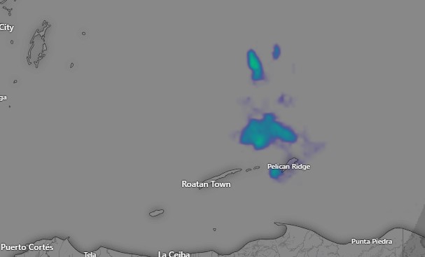
At 7:40 a.m. we have some showers between Guanaja and Barbarat. In the 8 o’clock hour some of these may make their way into eastern Roatan.

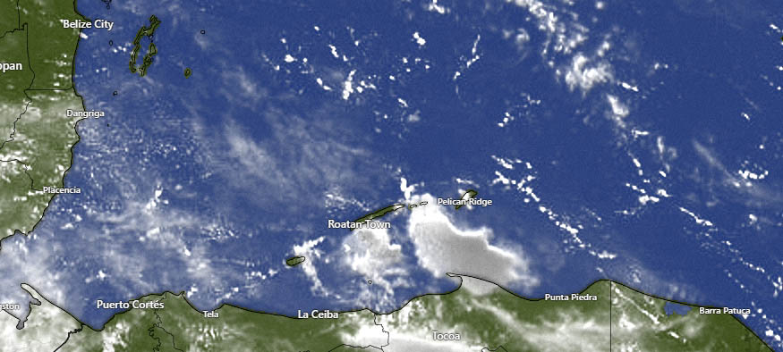
Over the next three days we will continue to have partly cloudy skies and small chances of overnight or early morning showers. Rain chances go up Sunday evening into Monday.
East winds today will be 15-20 mph and seas 3-4 feet (1-1.3 meters)
Winds tomorrow will be 10-15 mph and seas 2-3 feet (.6-1 meter)
The weekend looks quite calm, with winds 5-10 mph and seas 1-2 feet (.3-.6 meters). Low tide is 3:10 p.m., but it won’t be very low.

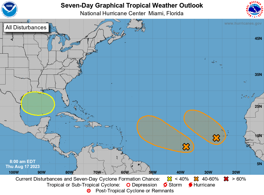
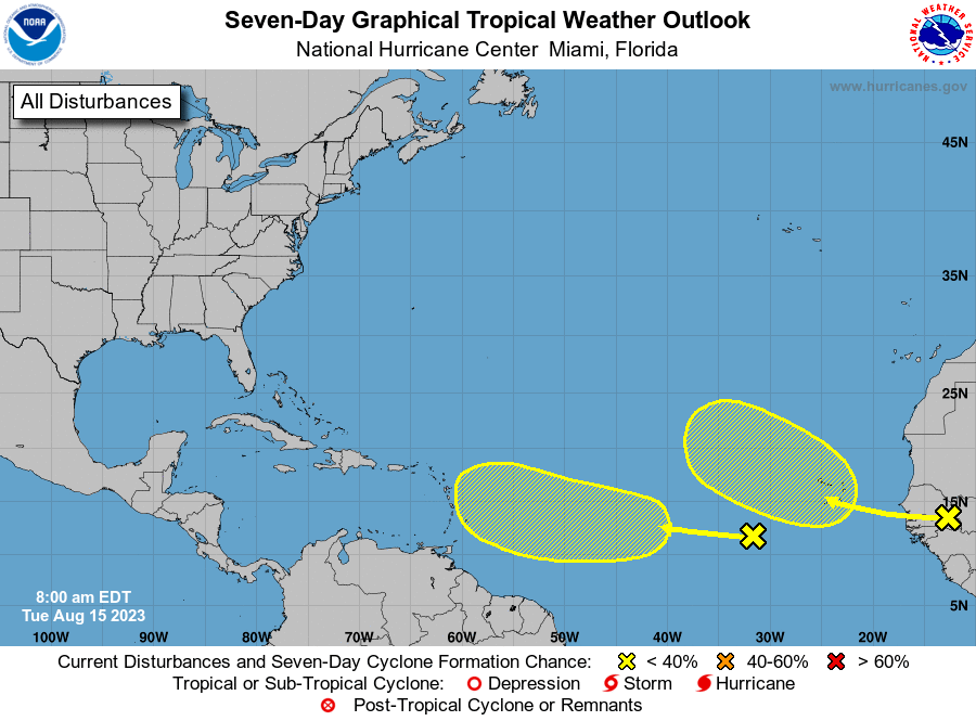
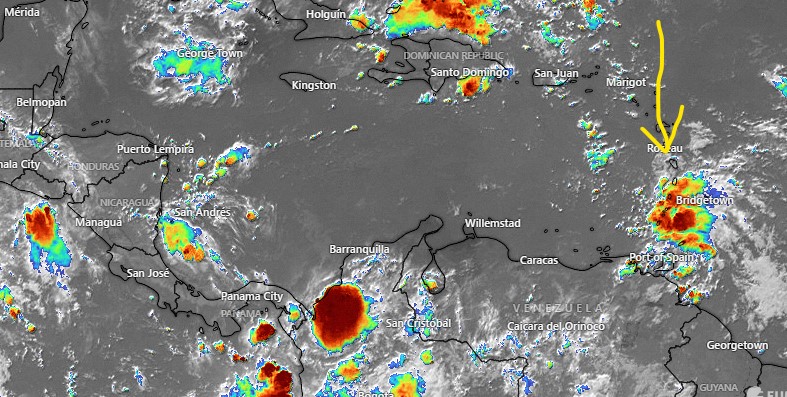
We’re still watching two potential tropical storms in the Atlantic. Most models aren’t forecasting much for these storms and, even if they develop, they will likely stay in the Atlantic.

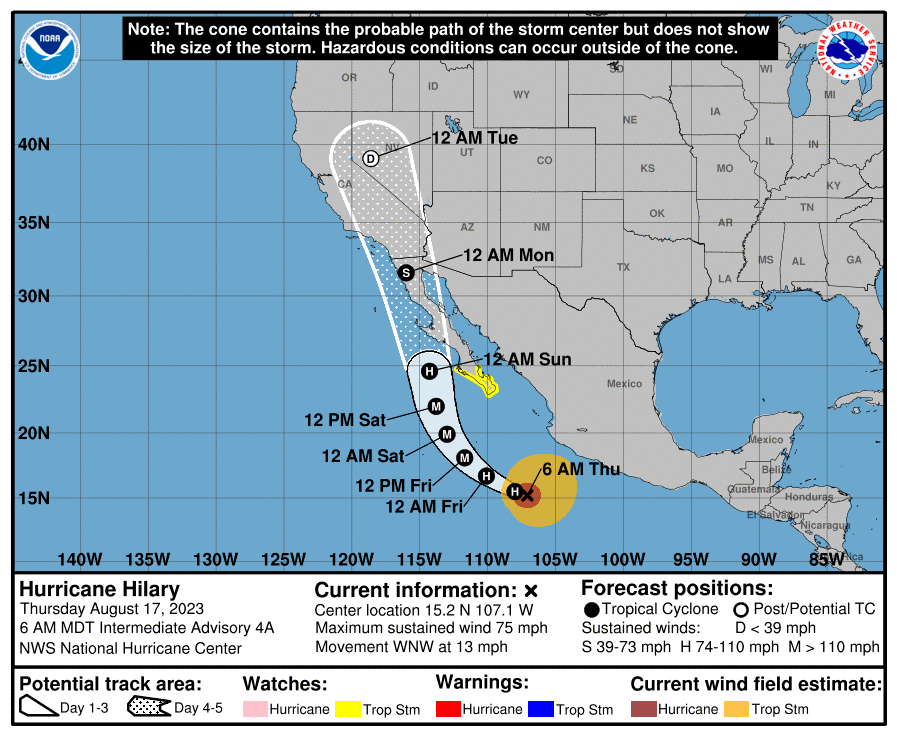
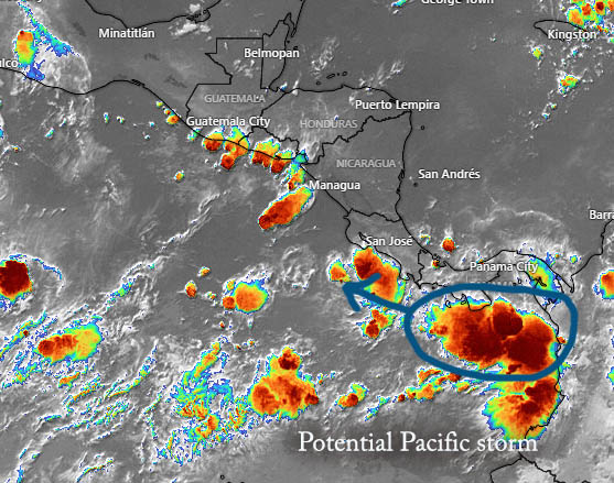
Hurricane Hilary is due west of Acapulco right now and there are tropical storm warnings up for southern Baja peninsula. If you have family or friends in Baja or southern California, they should watch out. Sunday night into Monday Hilary should move into southern California with heavy rains and some wind. A recorded storm has never moved into California as a hurricane, and only three storms have made it into California as tropical storms: Nora in 1997, Kathleen in 1976 and Long Beach storm in 1939. This one will very possibly become the fourth tropical storm to move into California. It will be a welcome relief from 115 degree temperatures for folks in the desert areas of southern California. Have a great Thursday!

August 15, 2023

Good morning Bay Islands. Last night some of us got a thunderstorm around 8 p.m. We even got a wind gust of 49 mph on Jonesville Point. But we only got .15 of an inch in the downpour. Many other locations reported a similar amount, though Palmetto Bay reported over half an inch and West Bay and West End reported none.

This morning we have storm clouds to our east which will give us a chance of rain through the morning hours, but the rain is generally moving to the northwest and most of it should miss us. Usually there isn’t a big difference in rain chances among the islands, but this morning I’d give Guanaja a 50/50 shot at rain this morning, 30 percent for Roatan and 20 percent for Utila.

Otherwise, today will be partly to mostly cloudy with east winds 10-15 mph and seas 2 feet. This week we will continue to see decent chances of rain during the night and early morning hours.
Wednesday through Friday look a little windier with east winds 15-20 mph and seas 3 feet during the day and 20-25 mph and seas 4 feet at night. This weekend winds should be calmer and late in the weekend or early next week rain chances go up. Low tide is 2:15 p.m.

There are two disturbances on the latest National Hurricane Center outlook. The one on the left has a very low (10 percent) chance of development through the next seven days, but its motion is generally toward the Caribbean. While none of the major computer models are making much of this, they do put a lot of moisture into the Caribbean next week and, this time of year with these water temperatures, anything can happen. We’ll keep an eye on it. Have a great Tuesday!

August 14, 2023

Radar at 6 a.m.

Aug. 14, 2023: Good morning Bay Islands. We have a few showers north of the islands, but we are mostly dry and sunny this morning. We will stay mostly sunny today with east winds 15-20 mph and seas at 3 feet. Tonight and tomorrow morning we will have a 30 percent chance of scattered showers and winds tomorrow and Wednesday will go down to 12-17 mph and seas 2-3 feet. Wednesday night winds will get back up to 20-25 mph. Through the middle of the week we will have a 20 percent chance of overnight and early morning showers and partly cloudy skies. Rain chances should go up this weekend. Low tide is 2 p.m. Have a great week!

August 13, 2023

Good morning Bay Islands. Last night we missed out on the rain, which was all around us but for the most part we stayed dry. We will definitely stay dry today, as you can see in the humidity map, some upper level dry air is moving in which will give us mostly sunny skies today.

We will also have quite a bit of wind from the east, helped in part by the Pacific storm to our south. East winds today will be 20-25 mph and 4 foot seas, getting up to 30-35 mph and 5-6 foot seas overnight. Tomorrow east winds will be 20-25 mph and seas 3-4 feet. Tuesday and Wednesday look a little calmer at 12-17 mph and seas around 3 feet. We will have decent chances of rain overnight and early mornings, 30-40 percent most evenings starting tomorrow evening. Have a great Sunday!

August 12, 2023

Good morning Bay Islands. We wake up to clear skies and moderate winds around 15 mph, with seas around 2 feet.
This evening we are expecting increasing clouds and scattered showers between sunset and midnight as a small area of moisture moves over.
Tomorrow should be dry, but windy. Winds will be from the east 17-22 mph with seas 4 feet during the day and gusting to 30 mph and seas 5-6 feet Sunday night. Starting Monday we will have better chances of scattered showers, about 30 percent most days, and east winds 15-20 mph with seas 3-4 feet. Low tide is 2 p.m. Have a great weekend!

August 11, 2023

August 11, 2023: Good morning Bay Islands. While the Atlantic and Caribbean have been quiet this year, the eastern Pacific has been quite busy. There is a storm on the Pacific coast of Panama that is expected to form into a tropical storm, perhaps as early as Sunday or Monday.

That won’t affect us directly, but it could be part of the reason we should have gusty winds on Monday, as easterly winds feed into the storm on the north side.
Today through Saturday looks mostly dry and sunny, with east winds about where they are now, 12-17 mph from the east and 2-3 foot seas. Saturday night into Sunday morning we have a decent chance of a shower, I’d say around 40 percent. Monday east winds will be 20-25 mph and seas 4 feet during the day and up to 30 or 35 mph and seas 5-6 feet Monday night. Starting Tuesday winds will be around 20 mph and seas around 4 feet. Next week will have higher rain chances, 30 to 40 percent each day throughout the week. Have a great Friday.

August 10, 2023

August 10, 2023: Good morning Bay Islands. Overnight the tropical wave we’ve been watching dissapeared, meaning that our chances for rain on Sunday just went down.
This morning we have clear skies in our part of the Caribbean, east winds around 15 mph and seas around 2 feet.
Those winds at 12-17 mph and seas 2-3 feet will continue through Saturday. Sunday still looks quite a bit windier, with east winds 20-25 mph and gusting up to 30 mph by evening. Next week looks windier than this week, as well.
We will be mostly dry through Saturday with only the slightest chance of an overnight or early morning shower.
Sunday the chances go up to around 30 percent for seeing a scattered shower, and those 30-40 percent chances last into next week. Low tide is 11:45 a.m. Have a great Thursday!

August 9, 2023

Good morning Bay Islands. Skies are quite clear in our part of the Caribbean this morning. Today will be mostly sunny.
Winds are continuing around 15 mph out of the east and seas at 2-3 feet as they have been for about the past week. Those moderate winds and seas should last until Sunday, when we expect windier conditions, especially in the evening.
Tonight we should have another 30 percent chance of rain, but tomorrow looks mostly sunny again. We will have mostly sunny days and small chances of rain overnight and in the early morning through Saturday.
Sunday our weather should change, with windier conditions and a better chance of rain.

That is because of a tropical wave right now over St. Vincent and Grenada in the Windward Islands. It is forecast to move in our direction, but it will just be an unorganized group of showers and storms. It will give us better chances of rain Sunday and Monday. Low tide is around 11 a.m. Have a great Wednesday!

August 8, 2023

Radar at 7:30 am.

Aug. 8, 2023: Good morning Bay Islands. At 7:30 a.m. we have some clouds and showers centered south of Roatan, bringing some showers to some locations. We’ve gotten .02 of an inch on Jonesville Point.

Satellite at 7:30 a.m.

We’re fortunate to catch these showers because most of the area around us is dry and we should be mostly sunny today and dry. I think tonight the chance of rain is much smaller than it has been the past few nights and early mornings.
Wednesday night we go back to these scattered late night and early morning showers and that cycle of early scattered showers and dry days should continue into the weekend. We’re still watching a tropical wave that may give us a rainier Sunday and Monday.
Winds are from the east around 15 mph and seas at 2 feet. We should continue to have winds 10-15 mph and seas at 2 feet during the day and 15-20 mph and seas at 3 feet during the evening.
Low tide is 9:40 a.m. Have a great Tuesday!

August 7, 2023

Radar at 7 a.m.

Good morning Bay Islands. We have scattered thundershowers around the island at 7 a.m.

Some locations got up to half an inch from a shower that passed over the island yesterday about 4 p.m.

Here is this morning’s rainfall.

We will be dealing with scattered showers through the morning hours, but clouds will decrease as we get to the afternoon. This evening will be breezy, with east winds 20-25 mph and seas 3-4 feet. (1-1.3 meters). There will be another chance of showers overnight tonight into tomorrow morning. Tuesday and Wednesday look mostly sunny and mostly dry with east winds 15-20 mph and seas 2-3 feet.
The US model still predicts tropical moisture to come this way next Sunday and Monday while other models push it north of us. Low tide is 8:15 a.m. Have a great week!