Aug. 5, 2022: Good morning, Roatan! The rain arrived early on the east side and Politilly got an inch in about 20 minutes. Today will be mostly cloudy with east winds 10-15 mph and seas at 2 feet (.6 meters). Don’t forget that winds with squalls will be higher, sometimes up to 40 mph. Rain chances will be around throughout the day and get even higher tonight and through the day tomorrow. Sunday we may get a break from the rain during the day. Starting Sunday and into next week we will have good chances of rain in the evenings and overnights, but lower chances during the daytime. Have a great Friday!
Aug. 4, 2022
Aug. 4, 2022: This morning the ocean looks as calm as a pond. Our winds here on Jonesville Point are around 3-4 mph which is quite rare. We got less than a tenth of an inch of rain overnight, but Coral View picked up about half an inch around 6:30 p.m. A few locations picked up a small shower around 3 a.m.
Winds should pick up a little, but only into the 10-15 mph range and seas to 2 feet (.6 meters). Chance for rain this evening and overnight is only around 20 percent. Tomorrow should be a little windier, at 15-20 mph and seas still at 2 feet. Rain chances will increase as the day goes along to about 50 percent. Rain chances will be best Friday night into Saturday at about 70 percent. Rain chances will be fairly high, around 50-60 percent, for Sunday through Wednesday. Monday and Tuesday look like calm on the sea. Have a great Thursday!
Aug. 3, 2022
Aug. 3, 2022: Good morning, Roatan! Most of us picked up another half an inch of rain yesterday, though one bucket in Sandy Bay got an inch and a quarter. So since July 31, most of us have gotten 2-3 inches of rain. Our cisterns are happy.
We should have a nice day today, with winds 10-15 mph and seas at 2 feet (.6 meters). There will be a chance of rain overnight, perhaps 40 percent. Tomorrow should also be a nice day with similar winds and seas and another 40 percent chance of a shower Thursday night. Friday and Saturday we will have about a 70 percent chance of rain even during the day. The rain could linger into Sunday morning. Have a great Wednesday!
Aug. 2, 2022
Aug. 2, 2022: Good morning, Roatan! At 7 a.m. most of the island is dealing with rain creeping in from the mainland. Almost all of us got a little more than an inch yesterday (West Bay was an exception, with only .42.)
Utila missed out with only .06 of an inch yesterday and none as of 7 a.m.
We will have to deal with the clouds and occasional showers through the morning, but I believe the afternoon will be drier and sunnier than yesterday. Winds, which have been variable this morning, will turn around from the east at 15-20 mph this afternoon and seas at 3 feet (1 meter).
If you want to dry out, tomorrow and Thursday should give us that chance, with mostly sunny skies, winds around 15 mph and seas at 2 feet (.6 meters). There will be a decent chance of a shower Wednesday night though. Friday evening, a higher chance of rain returns and those scattered showers will last through Sunday morning. Have a great Tuesday!
Rainfall for July 2022
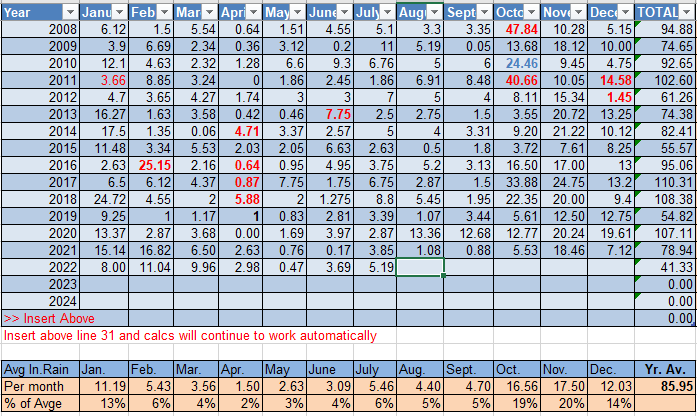
Rainfall for July 2022: We had quite a range of rainfall for the month on the island. The lowest reporting station was West Bay with 2.76 inches. The highest was Politilly with 7.33 inches. More typical across the island was Sandy Bay’s 5.19 inches, and that is what is going in the record book for this month. That amount is pretty typical of July. We are now entering a time period that tends to be a bit drier. August averages 4.4 inches and September 4.7 inches. Whenever anyone asks when they should visit the island, I usually recommend this time of year, partially because of less rain, but mostly because it seems to be a bit less windy, and when you want to get out on the sea wind is more important than rain (you’re going to get wet anyway). It also makes this time of year hotter, because the temperature on the island is almost always the same. The only thing that makes it cooler is cloud cover and wind, which there is typically less of in August and September.
Aug. 1, 2022
Aug. 1, 2022: Well, that thunderstorm last night was quite something else! Most of us have gotten over an inch of rain between yesterday and this morning before 7 a.m. More rain is possible. Compared the central and southern U.S., thunderstorms are actually pretty rare around here. For as often as weather apps indicate a chance of a thunderstorm, in my experience, we may get 20 in a year. Compare that to the southeastern U.S., where the number is more like 100 per year.
Today and especially tonight, there is a chance for more. We will have a good chance for a shower or thundershower throughout today and tonight. Skies will be partly cloudy. Winds will be from the east at 15-20 mph and seas at 3-4 feet (1-1.3 meters). Tomorrow the chance of rain will mostly be in the morning with winds around 20 mph and seas at 3 feet. Wednesday will be a bit calmer with winds 15 mph and seas at 2 feet (.6 meters). The chance of rain will be overnight. The chance of rain goes up Friday and Saturday. Have a great week!
July 31, 2022
July 31, 2022: Good morning, Roatan! We’ve had a lot of thunder around overnight and into the morning and lots of clouds, but most of us only have around a quarter to a third of an inch of rain in the bucket. As you can see from this morning’s satellite, we have a small system moving overhead.
Clouds will decrease as the morning goes along, but we will still have partly to mostly cloudy skies and a chance of a shower through the morning. Winds will be from the east/northeast at 20-25 mph and seas at 3 feet (1 meter). A good chance of rain starts tonight and extends through our Monday and Monday night. Otherwise we will have partly cloudy skies and east winds 15-20 mph. Keep in mind that during squalls, winds can get gustier. Tuesday afternoon through Thursday look to be drier, but Friday through Sunday the rain chances go back up.
July 30, 2022
July 30, 2022: Good morning, Roatan! No rain was recorded yesterday or this morning in any of the reporting sites on Roatan or Utila.
Today winds should continue brisk, from the east 15-20 mph during the day and 20-25 mph at night with seas 3-4 feet (1-1.3 meters). The chance of a shower tonight is 30 percent. Tomorrow winds and seas will be similar with a small chance of an afternoon or evening shower.
Monday and Tuesday the chance of rain goes up to 60 percent with winds remaining in the 15-25 mph range and seas at 3 feet (1 meter). Rain chances are lower Wednesday and Thursday. Friday into the weekend we will see good chances of rain, though winds should be calmer, especially on Friday. Have a great weekend!
July 29, 2022
July 29, 2022: Good morning, Roatan! We got a squall with gusty winds about 4 a.m. but only .01 of an inch in the rain bucket. Coral View got .12 of an inch around the same time. If you saw any, please leave it in comments.
Today should be a nice day, with winds at 10 mph and 2 foot (.6 meter) seas, getting up to 20 mph and 4 foot (1.3 meter) seas overnight. The chance of a shower tonight is around 30 percent.
Tomorrow will be a bit windier, with east winds 15-20 mph and seas at 3 feet (1 meter). Winds Sunday, even during the day, look to be around 20-25 mph and seas 3-4 feet. Through the weekend the chance of rain will be 30-40 percent, mostly at night. Rain chances go up Monday and Tuesday to around 60 percent, even during the daytime hours. Wednesday and Thursday should be drier and calmer. Rain chances go up next Friday into the weekend. Have a great Friday!
July 28, 2022
July 28, 2022: Good morning, Roatan! After those early morning rains yesterday, we have stayed dry and likely will stay that way the next 24 hours.
Today will be mostly sunny with east winds 15-20 mph and seas 2-3 feet (.6 to 1 meter). The rain chance tonight is quite low, maybe 10 percent. Tomorrow will be calmer, with winds 10-15 mph and seas at 2 feet during the day and 15-20 mph at night. The chance of a nighttime shower will be around 30 percent. Saturday and Sunday will be breezy with east winds 17-22 mph and seas 3-4 feet (1 to 1.3 meters) and the rain chance, especially Saturday night will be 40 percent. The computers are trying to make the weekend of Aug. 7 rainy. We’ll keep an eye on it. Have a great Thursday.
