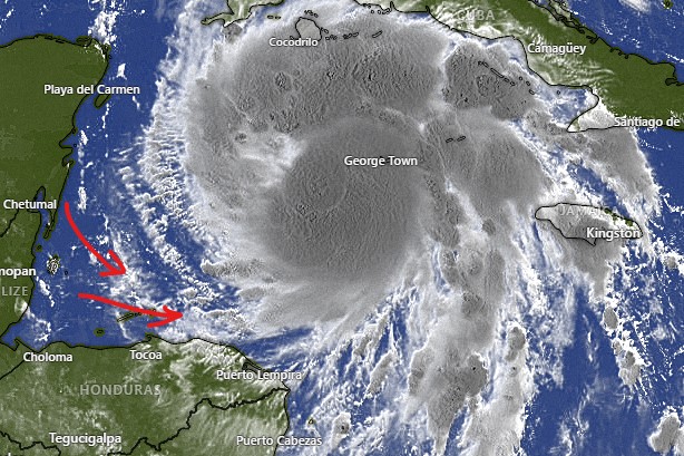
Sept. 4, 2022

Sept. 4, 2022: Good morning, Roatan! The most interesting thing that happened this morning didn’t come from the sky, but was under our feet. We had a 4.7 earthquake that rattled our windows here on Jonesville Point. This one was about as close as I can remember an earthquake. Several have occurred northeast of Guanaja, but this is the first one I’ve experienced northwest of Guanaja.

Now that we’ve gotten the quake out of the way, we can talk about the weather. There’s an area of rain and clouds near Puerto Cortes, but that is to our west and not headed this way. We will continue to have partly cloudy skies and mild winds out of the east at 10 mph. We have 2 foot seas (.6 meters) on the south side this morning. Those should calm even more tomorrow to around 1 foot and 5-10 mph winds. This week will be calm and fairly dry, with only a small chance of a passing shower, so perfect beach and sea weather. Have a great Sunday!

Sept. 3, 2022

Sept. 3, 2022: Good morning, Roatan! Clouds yesterday morning gave us a cooler than normal day. Today, under partly cloudy skies, we’ll be back to hot, but breezy conditions. Rain chances will be low and mostly overnight. Winds will be from the east 12-17 mph and seas at 3 feet (1 meter). Winds should calm into the 10 mph range starting Monday and the last half of the week looks particularly calm, so it should be a good week on the seas. Have a great weekend!

Sept. 2, 2022

Infrared satellite image at 7 a.m.

Sept. 2, 2022: Good morning, Roatan. If you want proof of how the rain has danced around us and missed us almost completely, take a look at this morning’s infrared satellite image. You will see the coast of Belize getting a good dose of rain this morning and Roatan on the back end of the clouds and no rain. Rain chances will be very low and we will have decreasing clouds and gusty winds. Winds will be 15-20 mph from the southeast and seas on the southside at 3-4 feet (1-1.3 meters).

Winds will be in the 15-20 mph range through Monday. The middle of next week looks calmer. Rain chances will be low through the period. Have a great Friday!

Rainfall for August 2022

Rainfall for August 2022: We had quite a range of rainfall totals on the island. The driest was West Bay with only 2.37 inches. The wettest was Politilly’s 7.06 inches. Politilly is almost due north of Jonesville Point and had twice the rain. Go figure. The number that is officially going in the record books is Sandy Bay’s 5.54 inches, which is about an average of what we got islandwide. Most of the rain came in the beginning of the month and was a little more than our average of 4.44 inches. September is very similar to August, usually pretty hot, with relatively low winds and an occasional shower. If anyone ever asks what month to visit Roatan, September is one of my top picks. It is the beginning of the time period we usually look out for hurricanes, a season which, for us, peaks in October. The end of October is the beginning of rainy season.

Sept. 1, 2022

Sept. 1, 2022: Good morning, Roatan! Yesterday turned out to be a beautiful day and one of the calmest ones we’ve had in awhile. Today the wind is up a bit in the 10-15 mph range with seas around 2 feet (.6 meters). That should continue and the winds will get up tonight around 20 mph. As you can see in this morning’s satellite, there are some clouds and probably some rain to our east. This will give us a chance of afternoon showers.

Starting tomorrow things get windier, with daytime winds around 15 mph and seas around 3 feet (1 meter) and nighttime winds 20-25 mph and seas at 4 feet (1.3 meters). The chance of a stray shower Friday through the weekend is very low. Have a great Thursday!

Aug. 31, 2022

Satellite image from 7 p.m. to 7 a.m. today

Aug. 31, 2022: Good morning, Roatan! Our tropical wave came close enough yesterday to give some of us a good downpour around midday. Coral View was the big winner with 1.15 inches. Politilly got a third of an inch as did one location in Sandy Bay. Punta Blanca got a tenth of an inch and here on Jonesville Point we only got .02 of an inch. West Bay and West End got no measureable rain.

As you can see in the satellite from 7 p.m. yesterday to 7 a.m. today, the tropical wave has shifted north toward Jamaica. That shift is away from us so I’m less optimistic about rain. I am optimistic about calm winds. The sea on the southside looks like a pond, a great day to go out on the water. We will keep a 40 percent chance of rain today and tomorrow morning. If we don’t get rain these two days, we may stay dry for awhile, because the forecast the next week or so after that has very low rain chances. Winds will come back up into the normal range of 12-17 mph during the day and 15-20 mph at night starting Friday. Have a great Wednesday!

Aug. 30, 2022

Satellite image around 7 a.m.

Aug. 30, 2022: Good morning, Roatan! The tropical wave we’ve been waiting for is finally in view. Some time between now and Friday there is a very good chance we will get some rain, but most models give us much less rain out of this than the mainland. Most of them predict around an inch for the whole week.

Pretty typical is the GFS map here that shows predicted rain through midnight Friday night. Winds and seas will be fairly calm unless you are in a squall. Rain chances will be around 40 percent today, 50 percent tomorrow and 60 percent Thursday and Friday. Skies will be partly to mostly cloudy. Have a great Tuesday!

Aug. 29, 2022

Satellite image as of 8 a.m.

Aug. 29, 2022: Good morning, Roatan! After a dry 24 hours, at 8 a.m. we have some storms and clouds moving in from the east. The question is will they hold together long enough to bring us a morning shower. These storms often fall apart as the day goes along, but they will at least bring us some clouds and a chance of rain during the morning.

Radar as of 8 a.m.

Here is this morning’s radar as of 8 a.m. You can see a large area of thundershowers moving in from the east. These storms often fall apart as the day goes along, but they will at least bring us some clouds and a chance of rain during the morning. We’ll see how well the hold together this morning.

Here is the latest tropical weather outlook. You’ll notice we still have a 20 percent chance of development over us. If it happens, it will be Thursday evening/Friday morning. The big red X is a potential hurricane that should get close to the Lesser Antilles. Right now models are turning it to the east before it has a chance to threaten the US.

Aug. 27, 2022

Aug. 27, 2022: Good morning, Roatan! Our weather has been fair for the last 24 hours and will continue to be that way until early to mid next week. The storm system we’ve been watching is now north of the ABC islands. The National Hurricane Center has lowered the possibility of tropical development to 20 percent. It has also adjusted the track to our north, and now we are no longer in the yellow predicted path. Our main question is whether it will bring rain Tuesday through Thursday of next week. The answer seems to be yes, but there is a big question of how much. We could get 2 to 3 inches or we could get none.

Until then winds will remain out of the east 12-17 mph and seas at 2-3 feet (.6 to 1 meter) on the southside. As the storm approaches, quite often the winds will calm a bit. We’ll keep an eye on it.

Aug. 26, 2022

Aug. 26, 2022: Good morning Roatan! The rain to our east fizzled out before it got here, so no rain on the island in the last 24 hours. Today there is a wave to our northeast so we will keep a small chance of a shower through the day today. Otherwise winds should be 5-10 mph and seas 1-2 feet.

Tomorrow through Monday look to be nice days with winds around 10 mph during the day and 15-20 mph at night and small chances of showers mostly at night.

The tropical wave is now just west of the Windward Islands and has a 30 percent chance of tropical development in the next five days. There is a lot of uncertainty about its exact movement. If it jogs a little to the north we could be mostly dry next week, but if it stays on course we will likely have times of heavy showers in the middle of next week, though it is unlikely to become a tropical storm by the time it gets here. We’ll keep an eye on it.