Oct. 12, 2022: Good morning, Roatan! Our good weather will continue nice. Today will be partly cloudy with east winds 12-17 mph and seas at 3 feet. Tomorrow should be the calmest day of the week, with light winds and seas at 1 foot. Friday winds will be 5-10 mph during the day and seas 1-2 feet and 15-20 mph at night. Chance of rain is low each day until we get to Saturday night, when it is 50-50. Have a great day!
Oct. 10, 2022
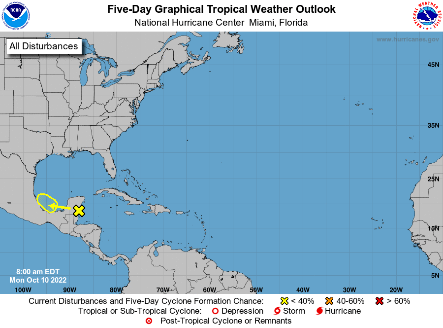
Oct. 10, 2022: Good morning Roatan!. Tropical Storm Julia was an incredible storm. She gave birth to twins. The storms the she created over us yesterday may become another tropical storm after it passes over Yucatan. It should have no affect on our weather.
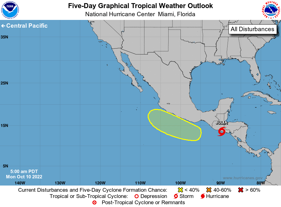
The remnants of Julia should continue off the Pacific coast of Mexico. This also will have no affect on our weather.
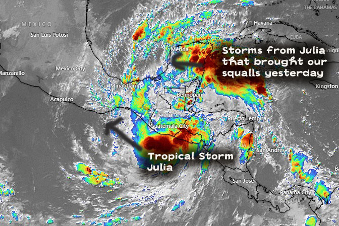
This is the satellite image this morning. Central America tore Julia in two. This morning it is still giving us brisk winds of 20-25 mph from the east and seas of 5 feet. Yesterday we had seas of 5-7 feet and maybe higher as the squalls passed.
Today, we will continue to have east winds 20-25 mph and seas at 5 feet. Skies will be partly cloudy with a 30 percent chance of rain, especially in the evening. Tonight, winds will calm a bit to 15 mph and seas to 3 feet.
Tomorrow will be partly cloudy with only a 20 percent chance of a shower. Winds will be 13-17 mph and seas 3-4 feet.
Wednesday should continue mostly dry with east/southeast winds 7-15 mph and seas at 2-3 feet.
Thursday winds and seas get much calmer and the rain chance gets a little better, especially this weekend. Have a great week!
Oct. 9, 2022
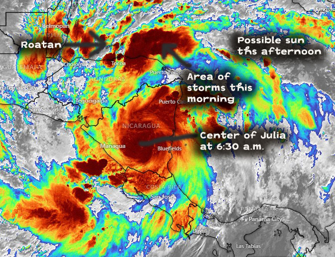
Oct. 9, 2022: Good morning, Roatan! Julia is still officially a hurricane about 100 miles east of Managua, Nicaragua. The center and most of the rain looks like it is staying in Nicaragua, so the mainland of Honduras will be spared the worst of it. Most of us have had about half an inch of rain since midnight. The west side got 1.5 to 2.5 inches of rain yesterday, the east side about an inch. Coral View recorded a 43 mph wind gust in a squall around 1:30 a.m., but winds have mostly been 10-15 mph. Seas look to be 4 feet on the southside and about 2 feet on the northside.
As you can see in this morning’s satellite image. There is an area of rain to our east which should bring us more rain, sometimes heavy, this morning. East of that you can see bands of clear skies and bands of rain. Depending on what comes our way, it is possible we’ll see sun this afternoon and lower rain chances.
Oct 8, 2022

Oct. 8, 2022: Good morning, Roatan! Rain totals overnight of half an inch were common across the island. As you can see from this morning’s 7 a.m. satellite, there is some rain approaching from the east. We will have increasing rain chances throughout the day. With 60 mph winds, Tropical Storm Julia is expected to strengthen today into a hurricane with landfall in the early morning hours tomorrow in Nicaragua.
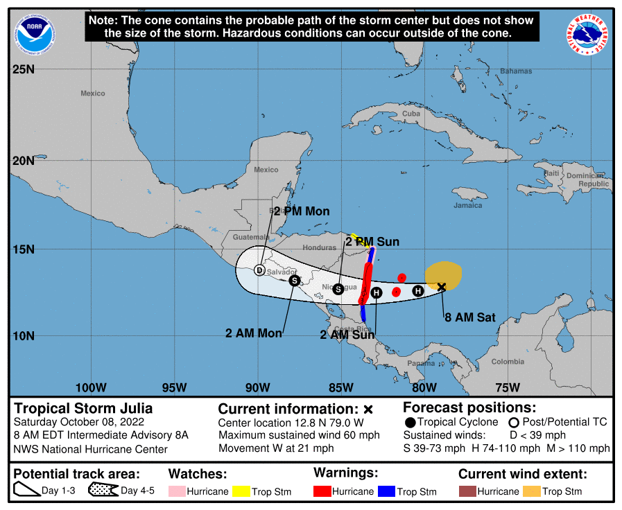
Since the storm is farther south, our wind and rain forecasts for the storm here on the islands are lower, 3-5 inches. Some models show a little more and there will always be spots with a little more and some with a little less, so flooding in areas prone to it is still a concern, but it doesn’t look as bad as it did yesterday. Winds also look better, likely 25 mph tomorrow afternoon into Monday morning, gusting to 30 mph. Seas are forecast to be 5-7 feet Sunday afternoon into Monday morning, and improving Monday afternoon.
Evening update for Oct. 7, 2022

Not a lot of change in the latest update. We are now well outside the cone for the center of the hurricane. We are still expecting heavy rain on Sunday and winds likely 25-35 mph with higher gusts.
Oct. 7, 2022
Oct. 7, 2022: We expect Tropical Storm Julia to be named today as it moves out to sea from Colombia. We expect torrrential rains Sunday, especially in the afternoon and there is definitely a flooding threat. Current wind prediction is 35-40 mph sustained winds and gusts to 45-50 mph possible, especially Sunday evening into Monday morning. Seas 7-10 feet (2-3 meters) are likely Sunday into Monday.
Evening update for Oct. 6, 2022
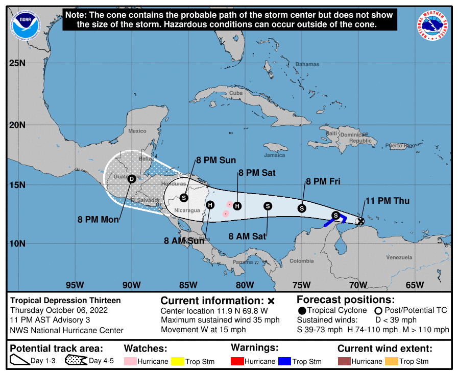
The storm is now officially a tropical depression. The forecast path is still similar but it is likely by the time we wake up tomorrow it will be a tropical storm. This is the time when we get a better idea as to its exact path.
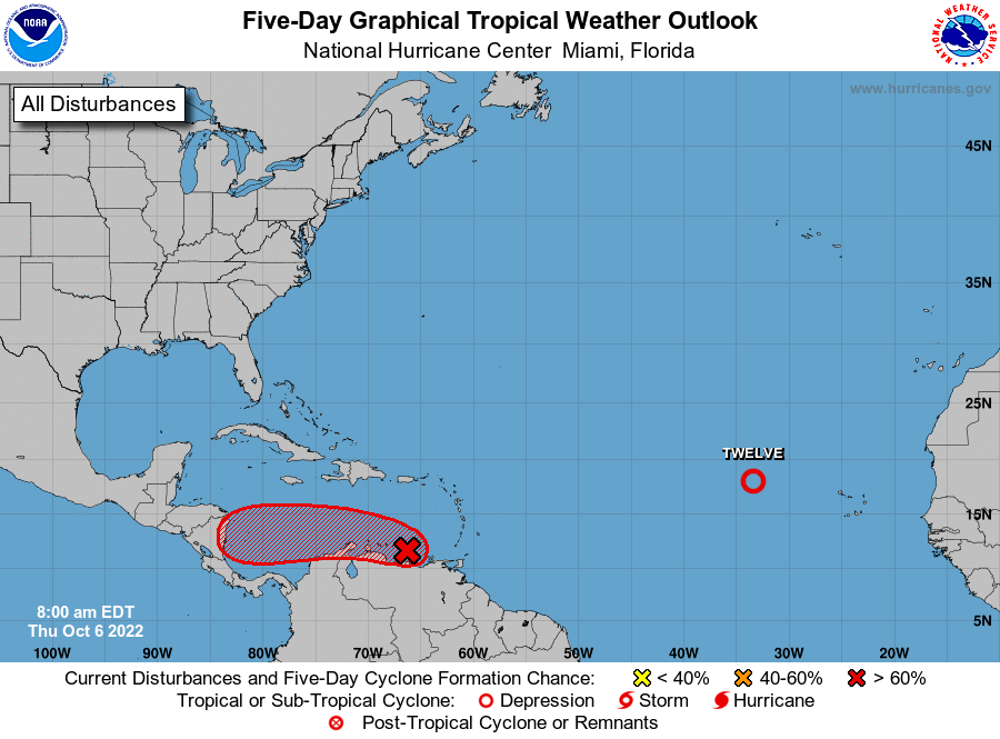
Tropical update for Oct. 6, 2022
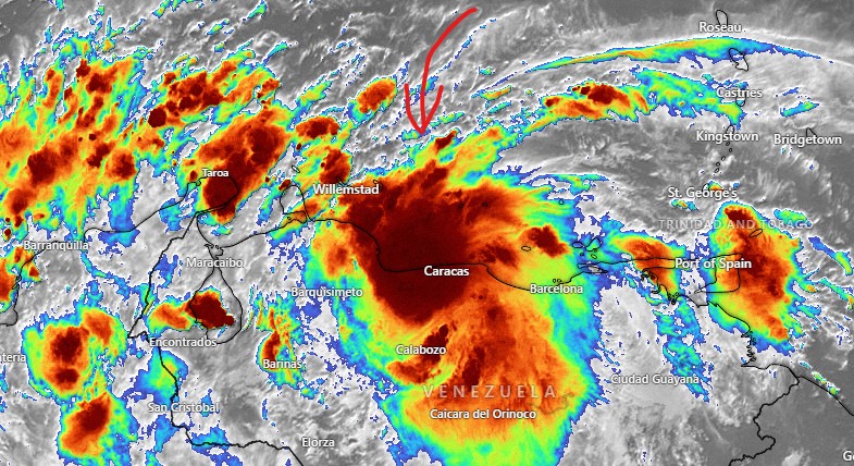
Tropical update for Oct. 6, 2022: Good morning, Roatan! Storm 91L is very close to Caracas, Venezuela after bringing torrential rains to Trinidad. Overnight, we got better agreement on a few things:
1. Any effects for us should come Sunday night into Monday morning.
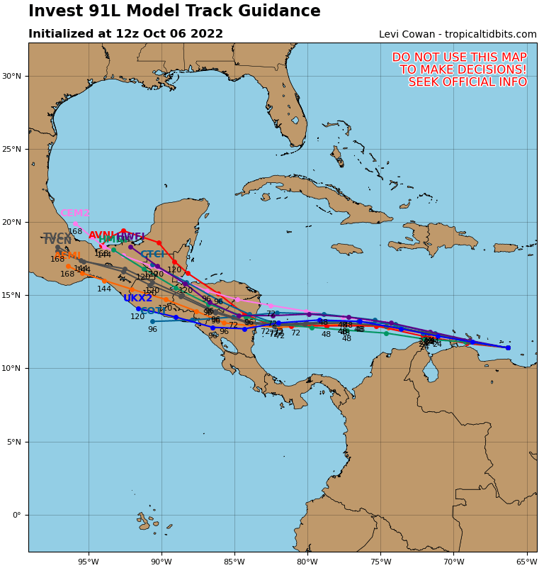
2. Models are mostly saying this hits the Nicaragua coast as either a Category 1 hurricane or a tropical storm (Caution: storms have a history of intensifying before hitting Nicaragua.)
3. There is a good chance the storm turns north after hitting Nicaragua and comes through the heart of the Honduran mainland.
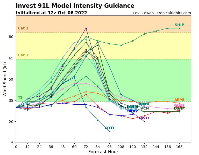
My main concern about this storm is the possibility of torrential rain after we’ve already had a weekend full of rain, causing flooding here and on the mainland. My concerns about high winds are less today than they were yesterday, though keep in mind that until this cyclone forms, we won’t know exactly where it will go. As it stands, winds 25-35 mph are in the forecast for Monday morning, but that can always change. Keep watchful.
October 6, 2022
Oct. 6, 2022: Good morning, Roatan. Let’s start with the forecast for today into the weekend.
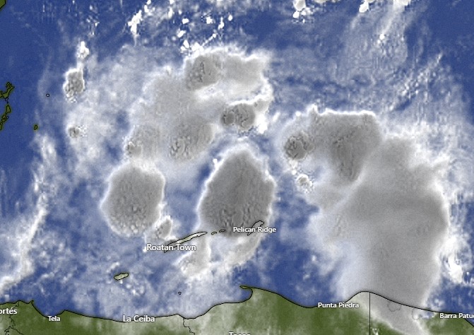
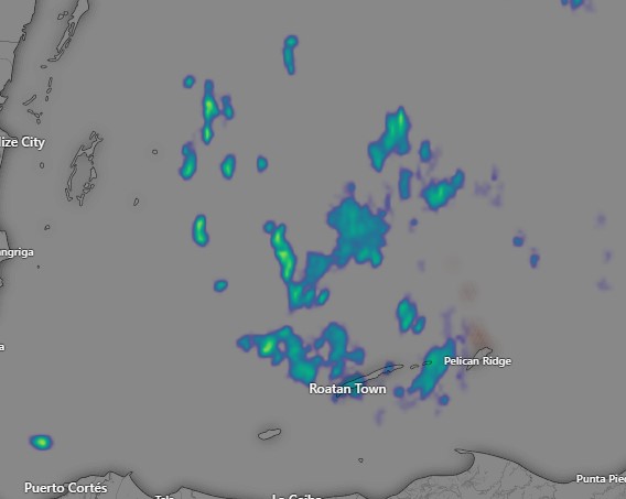
As you can see from the 6 a.m. radar and satellite images, there is a lot of rain around. Today will be mostly cloudy with occasional rain, light winds and seas 1-2 feet (.3 to .6 meters). Rain should get lighter and we may see more sun this afternoon. Tomorrow rain is in the forecast, but also periods of sun, especially in the morning. Winds remain calm, but seas continue at 2 feet (.6 meters). Saturday and Sunday also look rainy. To summarize, today through Sunday, mostly cloudy with periods of sun, but also periods of torrential rains, calm winds except in squalls, and 2 foot seas. I’m worried about flooding in some areas, with 4 to 5 inches of rain possible BEFORE any effects of the storm (91L) arrive here. More on the storm in the tropical update.
Oct. 5, 2022
Oct. 5, 2022: Good morning, Roatan! I did another video update about Invest 91L. One main concern is the amount of rain we expect to get, especially starting tomorrow. We have a very good chance of getting a lot of rain Thursday through Saturday and that is before any effects from 91L get here. If the storm comes closer to us, this will make a bad situation worse. Right now most models show the storm headed toward the Nicaragua coast. If this happens we are still in danger of getting tropical storm force winds on the island anywhere between Monday and Wednesday. Keep in mind the track is still highly in doubt, so be prepared. patreon.com/roatanweather
