Jan. 23, 2023

Jan. 23, 2023: Good morning, Roatan! We have something in the forecast for this week that we didn’t have last week. Rain! Probably not a whole lot of rain, but I think most of us will get wet, especially at the end of the week.

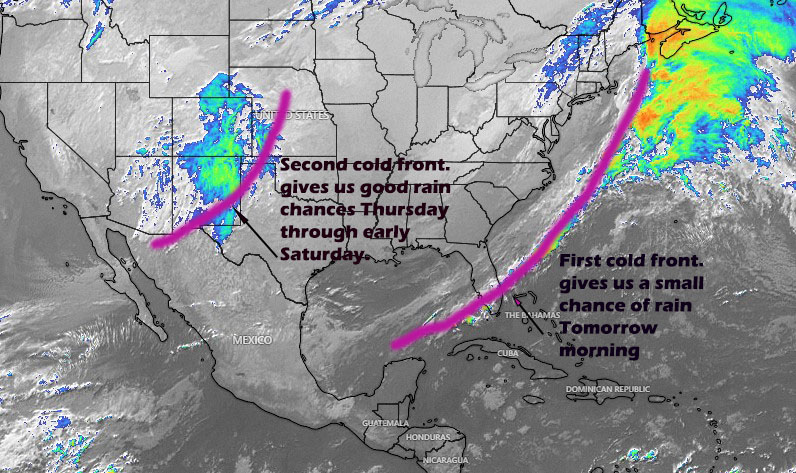
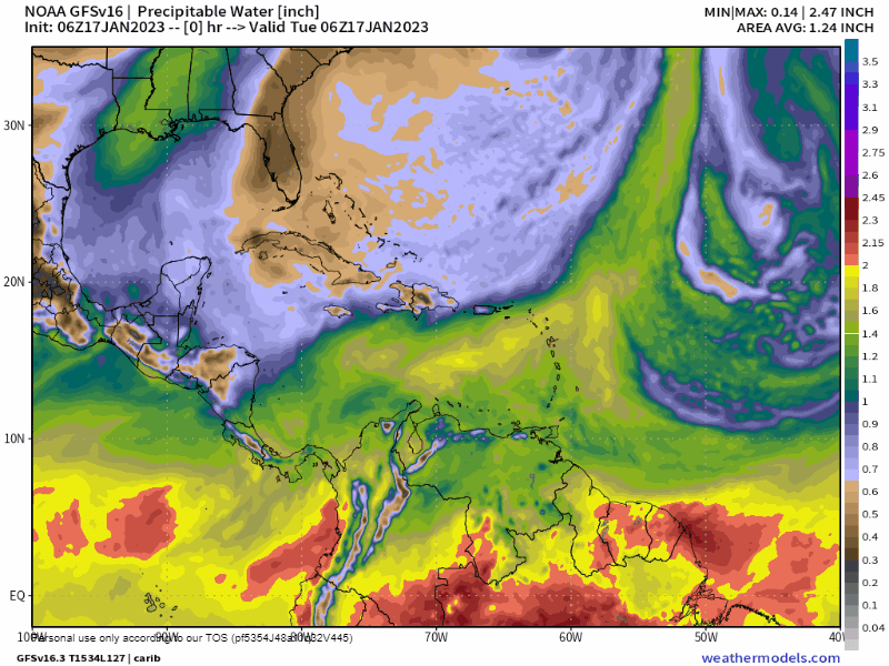
As you can see in the map, the first cold front (norther) is very weak and will collapse before it can bring us any northerly winds. But we have a chance at rain tomorrow morning, anywhere from midnight to around daybreak. The chance of rain will be better the further east you go. The second cold front will be stronger, but not strong enough to switch our winds to the north. Seas Thursday through Saturday will be from the northeast at 3-4 feet because of winds to our north, while our winds will stay in the 10-15 mph range. Rain totals should be better the further west you go, perhaps an inch in total for most of us.

The forecast today is for clear skies and winds getting calm this afternoon and seas at 2 feet.

Tonight we will have increasing clouds with a chance of rain after midnight (50 percent for Guanaja, 40 percent for the main island and around 20 percent chance for Utila).

Tomorrow will get windy in the afternoon, with east winds 20-25 mph and seas picking up to 5 feet by sunset.

Wednesday will be windy and dry, especially in the afternoon, with east winds 20-25 mph and seas 4-5 feet.

Thursday winds calm to around 10 mph and shift to the northeast. Seas will be around 3 feet Thursday through the weekend. The best chance of rain is Thursday night into Friday morning. Have a great week!

Jan. 22, 2023

Jan. 22, 2023: Good morning, Roatan! Our seas this morning are a bit calmer than they’ve been previous mornings. They are right at 3 feet (1 meter) and winds will calm as we go through the day to 10-15 mph, giving us 2 foot seas (.6 meters). Winds will get back to 20 mph and seas to 4 feet, but through the day tomorrow winds will calm to 7-12 mph and seas to 2 feet, perhaps a bit less in areas. Through the day Tuesday winds will be gusty again to 15-20 mph and Tuesday night to 25 mph.

Thursday through Saturday a cold front will get close enough to give us a good chance of showers through those days. Right now the rain totals don’t look like that much, and winds will continue to come from the east with perhaps a slight tilt to the northeast at times. Have a great Sunday!

Jan. 20, 2023

Jan. 20, 2023: Good morning, Roatan! We awake to seas between 4-5 feet near Roatan and 2 feet near Ceiba and winds 20-25 mph.

Today winds will not calm as much in the afternoon as they have previous days. Afternoon winds should still be 15-20 mph from the east, and seas 3-4 feet.

Tomorrow we should get some drier air, so the day may feel a little fresher than today. Sunday and Monday afternoon winds should calm to 7-12 mph and seas to 2 feet, but we’ll still be breezy overnight. There’s no rain in the forecast until at least Thursday and the following weekend look like one for scattered showers, but not a huge rain event. Have a great Friday!

Jan. 19, 2023

Jan. 19, 2023: Good morning, Roatan! Yesterday we mentioned that the east side was far windier than the west side and Utila, but last night Utila got up to 17 mph winds and the West Side about 20 mph. This morning we’re dealing with gusty winds and 4 foot seas, though only around 2 feet around Utila. We have some clouds to our east, but those will only bring us mostly sunny skies and no real chance of rain. Winds will calm today around 15 mph from the east and seas to 2-3 feet before rising again tonight to 20-25 mph and 4 feet. Today and tomorrow we will we a little more humid which will make it feel hot, though some drier air is on the way for the weekend which should make it feel a little cooler (though not as cool as it did Monday). No rain until the end of next week, and even then it doesn’t look like a huge chance of rain. Long-range forecasts give us good rain at the end of the month and the first of February. We’ll keep an eye on it. Have a great Thursday!

Jan. 18, 2023

Jan. 18, 2023: Good morning Roatan! We wake up to 25 mph winds from the east and seas at 4 feet, especially on the east side of the island. As you go west, the less wind you have, especially in Utila, which has almost calm winds and 2 foot seas. Like we always say, when we have these easterly winds, your ferry trip may start out a little choppy, but it will get calmer as you head toward Ceiba.

Even here in Roatan, winds will calm by midday to 10-15 mph and seas to 2-3 feet. We will continue this cycle of quite windy nights (20-25 mph, seas 4-5 feet) and somewhat calmer days (12-17 mph, seas 2-3 feet) for the rest of the week in to the weekend and into the beginning of next week. The next good chance of rain comes midweek next week. Have a great Wednesday!

Jan. 17, 2023

Jan. 17, 2023: Good morning, Roatan! We enjoyed a day of sunshine a fresh winds yesterday. That was the pleasant feeling of dry air that we don’t get very much in the tropics. For most of us, we didn’t get above 79 degrees (26C) despite having full sun all day, and our dewpoint (a measure of how much humidity is in the air) didn’t get above 71 (21C). Those temperatures give us a heat index (what it feels like) of 82 (28C). Compare that with a typical day in May when the temperature is 89 degrees (32C) and the dewpoint is 79 (26C). That gives us a heat index of 105 (41C). When you have dry air like we have right now, you can really tell the difference when you’re it in the shade. It feels much cooler than being in the sun. When it’s very humid, even being in the shade feels hot.

We don’t need to talk about rain this week, because it’s not going to rain, so I thought we’d talk a bit more about how it’s going to feel this week.

I’ve posted a map that shows the moisture in the air through Thursday Jan 26. Blues and browns are dry air, yellow is a little moister and red is very moist. You will notice Wednesday afternoon and Thursday we get some yellow, which means the humidity will go up those days. That will make it feel a bit hotter. But we get dryer air Friday into the weekend. That makes it feel fresher. Not until Thursday Jan 26 do we get the kind of moisture that will give us scattered showers. So for the next week we’ll have sunny skies with temperatures that are warm, but “not too hot for around here,” and breezy days with seas around 3 feet, windy nights with seas around 5 feet. Have a great Tuesday!

Jan. 16, 2023

Jan. 16, 2023: Good morning Roatan! Several of us got into the upper 60s this morning, with Sandy Bay recording a low of 66.7 degrees (19.3C), just .7 of a degree from our all-time low on the island. Yesterday was the kind of cloudy, wet day we usually associate with northers. No more of that this week.

Satellite image at 7 a.m.

We have some low clouds to our east, but they shouldn’t be anything to worry about. We will have partly cloudy to mostly sunny skies today with winds turning to the east at 10-15 mph and seas 2-3 feet (.6-1 meter). This will be the first day of a very dry week.

Tonight winds will pick up to 18-23 mph and seas to 4 feet (1.3 meters).

Tomorrow winds will be 10-15 mph and seas to 3 feet (1 meter).

Look for some gusty nighttime winds, perhaps gusting to 30 mph, especially Wednesday night and Thursday night. Daytime winds should calm to 10-15 mph. Have a great week!

Jan. 15, 2023

Jan. 15, 2023: Good chilly morning, Roatan! We got down to 69 degrees (20C) here on Jonesville Point, as did Politilly. Here on the east side we’ve picked up some light rain this morning as well. On the satellite there are clouds and a few showers to our north. Today we should see mostly cloudy skies with peeks of sunshine, but we will also have a chance of light rain at times. Winds will be light and seas on the north side should be 3-4 feet (1-1.3 meters).

Tonight skies will clear and winds will turn to the east, rising to 15-20 mph by tomorrow morning, seas will be around 3 feet. Tomorrow morning will start off cool, but will warm quickly with mostly sunny skies. We should have mostly clear skies all week and virtually no chance of rain. Winds will be moderate on Tuesday around 10-15 mph and seas 2-3 feet, but starting Wednesday through next weekend, winds especially at night will be gusty to 25 mph and seas will be around 5 feet at night and early morning and 3-4 feet during the day. Have a great Sunday and enjoy our last full day of cool weather.

Jan. 14, 2023

Jan. 14, 2023: Good morning, Roatan! Our cold front has passed and most of us only got a little rain, though Punta Blanca on the east end got .6 of an inch. Winds this morning are from the north gusting to around 20-25 mph, not bad as northers go, and seas on the north side are 4-5 feet (1.3-1.6 meters), not quite as bad as we were worried about.

You will notice the West Bay live cam from Bananarama shows West Bay Beach much wavier than normal at 7 a.m. Seas should stay around 4-5 feet this morning and calm a bit this afternoon to 3-4 feet as winds calm to around 15 mph. As those north winds hit the mountains of the mainland, it should create some low clouds that will keep up mostly cloudy through today and give us an occasional sprinkle, but we shouldn’t get a lot of rain today. The main impact of this norther will be the fresh temperatures. This morning the Belize coast is around 67 degrees (19C) and the air is quite dry for around here. The air will move over us and give us a fresh day today and a cool morning tomorrow.

Tomorrow will start out with some of the coolest temperatures we’ve felt. I’ll be looking for some upper 60s (around 20C). Winds will be light and seas around 2 feet (.6 meters). Morning clouds will give way to afternoon sun and it should be a beautiful day.

Monday we will see the easterly winds come back around 20 mph and seas 3-4 feet. Next week will be dry and sunny.

Tuesday should be the best day on the sea next week with daytime winds around 10 mph and seas around 2 feet here and 1 foot at Ceiba, but the rest of the week looks gusty, especially at night and in the early morning. Have a great, fresh weekend!

Jan. 13. 2023

6:30 a.m. satellite image.

Jan. 13, 2023: Good morning, Roatan! We wake up with some rain on the west side and near Utila at 6 a.m. Our winds are fairly calm and seas 1-2 feet (.3 to .6 meters). Today we will have partly cloudy skies and scattered showers, especially in the early morning and late evening. Winds will slowly increase from the north to around 10-15 mph.

Our cold front will pass through early tomorrow, probably around 7 or 8 a.m. and as it nears our seas will get choppier, around 6 feet by 9 a.m. Winds will be gusting 20-30 mph out of the north in the morning. They will get calmer as the day goes along, to around 10-20 mph by tomorrow evening. We should have a line of showers pass through along the cold front, after that we will have clouds and light rain off and on along with the north wind which will make it a fresh day. Take your jacket to stay dry and warm. The rain totals probably won’t be very high, but when we get these northers, we often get light, blowing rain along with clouds. That’s the kind of day tomorrow will be.

Tomorrow night and Sunday morning winds will calm to 10-15 mph and seas to 3 feet (1 meter), 2 feet toward La Ceiba. We may see some sprinkles Sunday morning, but it will be mostly dry and partly cloudy. Sunday night into Monday we will have dry conditions and winds turning to the east 15-20 mph and seas 3-4 feet.

Sunday morning and Monday morning I will be watching for some low temperatures 68-69 degrees (20 Celsius). Highs Sunday should be around 77 (25C).

Next week looks dry and windy, especially at night and in the early morning hours. Have a great Friday and take a jacket tomorrow!