Sept. 7, 2023: Good morning Bay Islands. We wake up to mostly sunny skies and east winds around 15 mph and seas at 2-3 feet. The closest rain is over in the Guatemala-Belize coast and it isn’t coming our way. Winds and seas will stay right around 15 mph and 3 feet today before calming a bit tomorrow to 10 mph and 2 feet.
We will continue to have 20-30 percent chances of rain overnight and mostly dry days. Low tide is 10:30 a.m. This is a pretty typical, quiet island forecast. Enjoy!
September 6, 2023
Sept. 6, 2023: Good morning Bay Islands! Around 6 a.m. a thundershower formed to the east of Guanaja. It doesn’t look like it’s moving very fast, but keep an eye out in Guanaja this morning. For the rest of us, we will have a small chance of a morning shower, but most of us will stay dry. Today will be partly cloudy with east winds 7-12 mph and seas around 2 feet. Tonight we will again have a 30 percent chance of a shower with east winds 12-17 mph and seas around 3 feet. The rest of this week should be much the same. Low tide is 9:30 a.m. Have a great Tuesday!
September 5, 2023
Sept. 5, 2023: Good morning Bay Islands. We wake up to clear skies and east winds 10-15 mph. We will be windier than we’ve been in the past, which will be good for the east side, since we will be out of RECO all morning. East winds will be 10-15 mph during the day and seas around 2 feet and 15-20 mph this evening and overnight and seas 3 feet. We will have around a 30 percent chance of an overnight shower this week. Those chances go up to around 40 percent this weekend. Have a great Tuesday
September 4, 2023
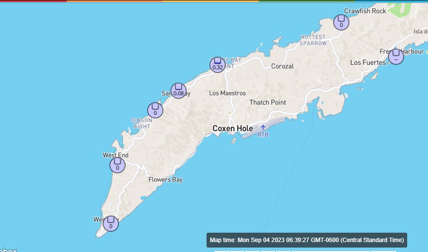
Good morning Bay Islands. Sandy Bay picked up a morning shower around 5:30 good for a third of an inch. There may still be a few showers out there, but they are few and far between. We’ll be mostly sunny and dry today with light winds and fairly calm seas. Starting tomorrow we will be a little windier, with daytime winds 7-12 mph and seas 2 feet and nighttime winds 12-17 mph and seas at 3 feet.
Tonight there is only a small chance of an overnight shower, but that chance goes up to 40 percent tomorrow night into Wednesday morning.
Low tide came early this morning at 6:30 a.m. and our next low tide is 8 a.m. tomorrow.

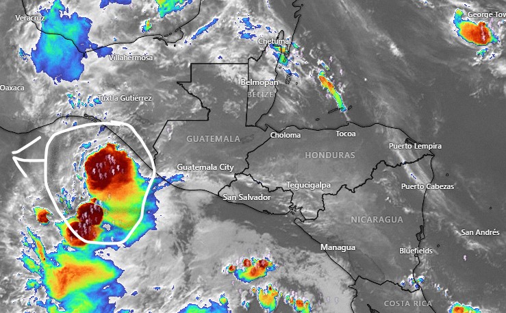
Taking a look at what’s going on in the Atlantic, the red X belongs to what will likely become Hurricane Lee. But Lee will turn north before entering the Caribbean, so we have nothing to worry about from him. The eastern seaboard of the US should be on alert, but one thing that may help them out, the Atlantic was cooled by the water churned up by Hurricane Franklin, so that may weaken the storm before it can threaten the US. Right now, there’s nothing to worry about in our part of the Caribbean. Have a great week!
September 3, 2023
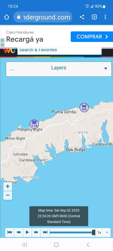

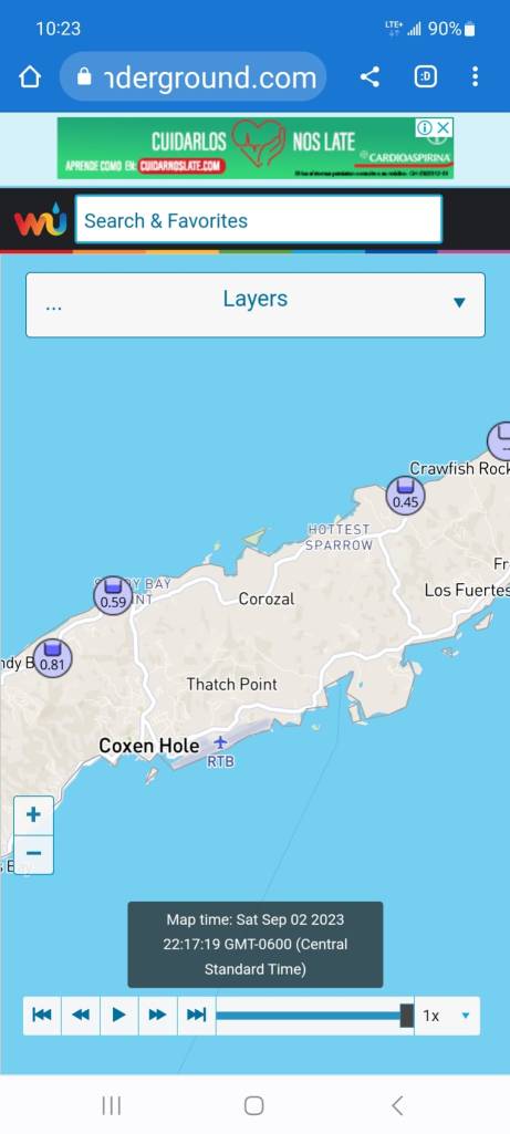
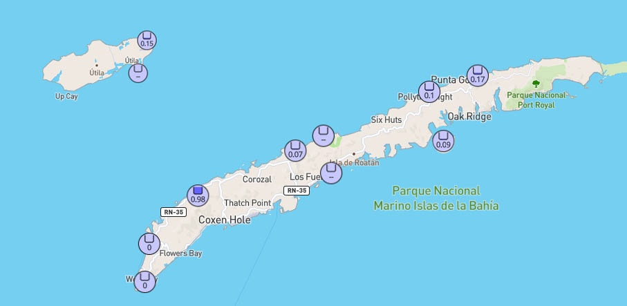
Good morning Bay Islands. Here are some rain totals from last night’s storm. We were out of power most of the night on Jonesville Point and even had a 30 minute outage this morning around 7:30 p.m.
We’ve had a few showers around the island this morning. We will have scattered showers this afternoon and overnight. Winds should calm to 5-10 mph and seas will be 1-2 feet, except in squalls. We will continue to have scattered showers, especially at night, this week. East winds should get a little windier starting Tuesday. Have a great Sunday!
September 2, 2023
Sept. 2, 2023: Good morning Bay Islands. Our storm system from last night moved quickly across the mainland and is out in the Pacific this morning. Around 5 p.m. yesterday we got a gust of 40 mph on Jonesville Point and a tree fell in a friend’s yard in Lucy Point. West Bay picked up a 35 mph gust. But it was a lot of noise and not a lot of rain. All reporting stations reported between a tenth and a third of an inch of rain.
Today we will have east winds 15 mph and seas around 3 feet. Tomorrow and Monday should be calmer at 5-10 mph and seas 1-2 feet. Starting Tuesday we should have fairly calm days with east winds 7-12 mph and seas 1-2 feet and nights with winds 10-15 mph and seas 2-3 feet.
We will also be in a typical September weather pattern, with a fairly low chance of rain during the day, and a better chance of rain overnight and in the early mornings. But any showers we get will be scattered and should pass quickly. High tides are 11 a.m. and 10 p.m. and low tide is tomorrow morning at 5:15 a.m. Have a great weekend.
Rainfall for August 2023
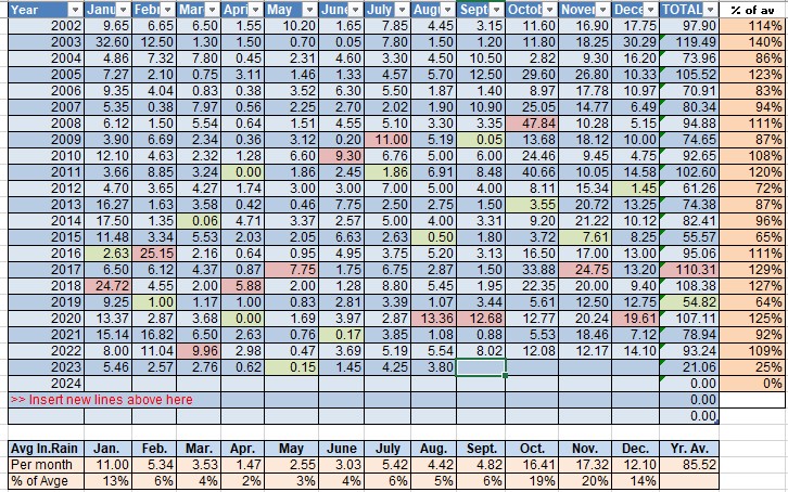
Rainfall for August 2023: We’re putting 3.8 inches in the books for August and that is a little above average across the island. Most locations got a little under 3 inches, but we will stay with Sandy Bay’s total for consistency. Even that is still below average for the month and we are two-thirds of the way through the year with only a quarter of the total expected rainfall for the year. We are well on our way for having a worse drought year than 2019 was. September is another 4 inch average month and is our last month before the wet season should start, halfway through the month of October. If anyone ever asks what is the best month to visit Roatan, I ALWAYS say September. We have generally calm seas and not a lot of rain and not a lot of crowds. But, of course, who listens to me? 😉
September 1, 2023
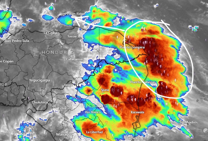
Good morning Bay Islands and welcome to September. The tropical wave we’ve been talking about for the last week will make it here today, mostly this afternoon.
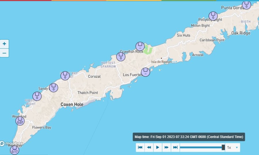
Some pieces of energy from the Mosquito Coast actually made it here this morning and gave some showers to West Bay and West End. These rain totals are as of 7:42 a.m. We start the day windier and wavier than we’ve been for quite awhile, with east winds 15 mph and seas at 3 mph. Those winds and seas will last through the day tomorrow and will get gustier in squalls. While we expect rain this afternoon, it will be weaker and more scattered than what we see on the Mosquito Coast. So expect a 60 percent chance of showers and thundershowers this afternoon, some of them heavy. The 60 percent chance of rain continues overnight into early Saturday morning, but goes down to 30 percent during the middle of the day and afternoon Saturday. Saturday night look for a 40 percent chance of rain. Sunday and Monday should be calmer, but winds go back up to 15-20 mph Tuesday and into next week.
BTW, our super moon low tides haven’t been that bad, but our high tides have been pretty high. High tide today is 9:45 a.m. and 9:30 p.m.
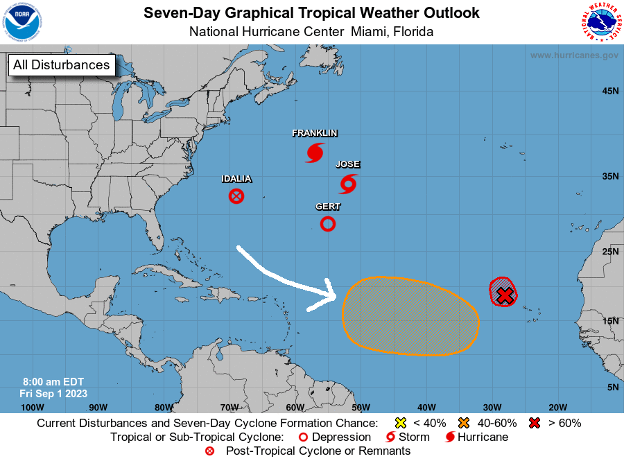
The Atlantic is pretty crowded today, with four named storms, but there is only one area of interest to us. It is the area in orange, with a 50 percent chance of tropical development in the next week. Most models show it forming a tropical storm or hurricane, but turning to the north before entering the Caribbean. It is far enough south for us to keep an eye on, though. Have a great Friday!
August 31, 2023
Good morning, Roatan. We had a thundershower move through about 2 a.m. Most of us got about a tenth of an inch, but West Bay and West End recorded no rain, but Sandy Bay got almost an inch.
This morning we have quite a few clouds around but we should get sunnier as the day goes on. Winds today will be light and variable with seas 1-2 feet (.3 to .6 meters). Tonight through Saturday winds will pick up to 15-20 mph from the east and seas will be 2-3 feet (.6-1 meter). Clouds will increase Friday and Friday evening into Saturday morning we will have a 60 percent chance of showers and thundershowers. Saturday and Sunday will continue mostly cloudy with 40 percent chances of rain during the day and 60 percent at night.
Winds and seas will be calmer Sunday into the first part of next week. Have a great Thursday!
Aug. 30, 2023
Aug. 30, 2023: Good morning, Bay Islands! We wake up to thin clouds and calm conditions. Those calm conditions should last through the day tomorrow. Tomorrow evening through Saturday, we will have a little breezier conditions, with east winds 15-20 mph and seas 2-3 feet (.6-1 meter).
Rain chances will be low through Friday, but Friday evening into Saturday morning we will have a wave of moisture come over us. That moisture has a good chance of becoming a tropical storm when it makes it into the Pacific, but when it passes over us, it will be fairly weak. It will give us cloudy skies and about a 40 percent chance of rain. Low tide is 2 p.m. Have a great Wednesday!
