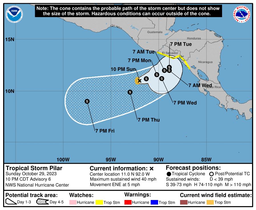
Here is the latest map on Pilar, which is expected to take a U-turn when our norther arrives Tuesday night into Wednesday morning.
Our chances of a tropical system in the next seven days are up to 30 percent. The GFS is showing a hurricane for the weekend. Of course that is just one prediction and is factored in to the 30 percent chance. Wind shear is low in the southern Caribbean and winds from our north will force any system to move west, so if one forms, we need to watch out.
Good morning. I did a Facebook live forecast today to get rid of glitches. The headlines: Some showers this morning, hopefully drier this afternoon and tomorrow. I’m very concerned about high rain totals starting Wednesday and the possibility of a tropical storm developing into the weekend.
Good morning Bay Islands. I have another video forecast for you today. The highlights:
Nice weather today into Tuesday morning with only a low chance of a small shower here or there.
I’m very worried about the norther coming Wednesday into late week and the weekend. Forecast rain totals are quite high and it is even possible a small tropical system could form somewhere nearby in the midst of all this rain. High tide is 8:30 a.m. and 8 p.m. Seas will be 3 feet today, 2 feet tomorrow and 1 foot Monday and Tuesday. Have a great weekend!
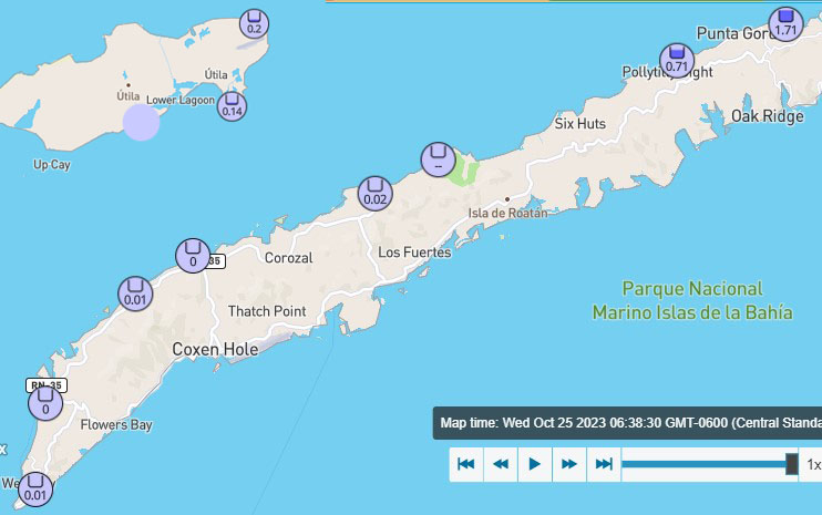
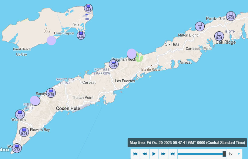
Good morning Bay Islands. Here’s today’s rainfall as of 6:30 p.m.
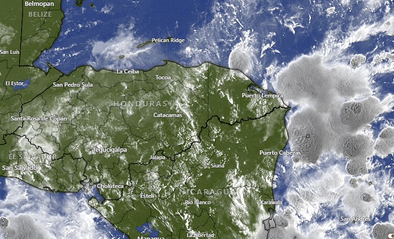
Satellite at 6:50 a.m.
We see scattered showers and a few rumbles of thunder on satellite
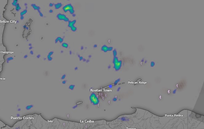
Radar at 6:50 a.m.
and radar at 7 a.m. There isn’t as much activity as yesterday and I expect rain to be less than it was yesterday, but we will still have scattered showers, with perhaps some sunshine this afternoon. Winds will be from the east around 15 mph and seas at 3 feet. Tomorrow and Saturday should be drier, with a 40 percent chance of showers, mostly in the morning, and some good sunshine in the afternoon. Winds will continue from the east 15 mph and seas at 3 feet.
There is still a great deal of uncertainty about the tropical disturbance south on Honduras.
Right now it is expected to drift slowly to the northwest over the next couple of days. A few models have it crossing back over Honduras and bringing us increased showers Sunday or Monday. We’re still looking for a norther Wednesday or Thursday next week. Have a great Thursday!
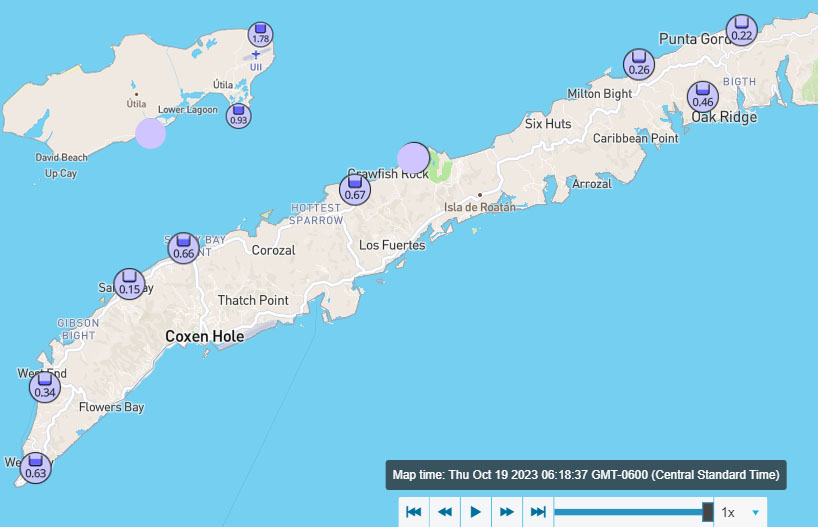
Good morning Bay Islands. As of 6:40 a.m. the west side has gotten very little rain and the east side has gotten a lot.
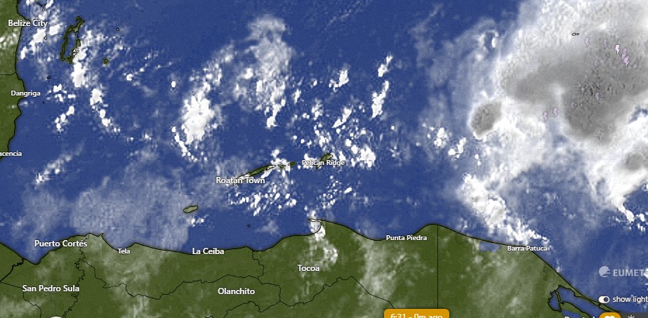
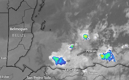
Satellite at 6:45 a.m.
Most of the rain on the east side came from the first storm you see forming around 2 a.m. the rain that followed missed us mostly to the north. There is another round coming, that is getting close to Guanaja at 6:47 a.m.
Today should be a day of lots of clouds and scattered showers. Our islands have missed a lot of the rain that’s been around us the last couple of days. That’s what happens when you’re small islands in a big sea. But if you get under one of these downpours, it can add up quick, as it did this morning with almost 2 inches in Punta Blanca. Tomorrow we will also have scattered showers, but probably fewer than today. Friday into the weekend is looking pretty good, with low chances of rain. Winds will continue to be from the east around 15 mph and seas around 3 feet through Saturday. Sunday and Monday seas should calm to 1-2 feet.
There is a good chance of another norther mid to late week next week, though there is disagreement about how strong it will be. We’ll keep an eye on it.
There is a little bit of uncertainty in the forecast because of the tropical disturbance that moved across Nicaragua yesterday. It is now in the Pacific and generally expected to move west. But some models show it drifting north, and if it does, it could increase our rain chances Friday into Saturday.
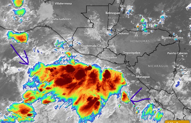
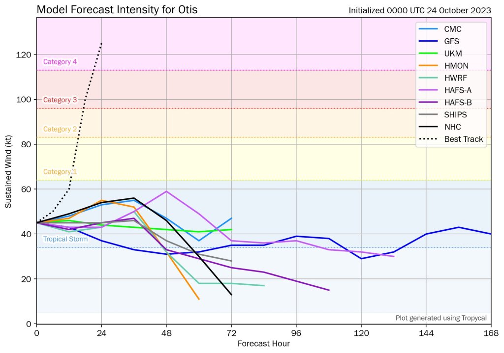
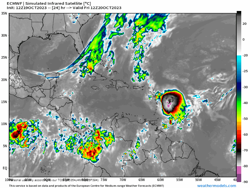
Speaking of what we expect to happen, I want to talk about Hurricane Otis, which slammed Acapulco, Mexico with 165 mph winds last night. It is the strongest storm to ever make landfall in the eastern Pacific. This chart shows what the computer models forecast, barely a tropical storm. In one night it went from tropical storm to Cat4-5 and moved inland in a way that was also unpredicted. Computer models are usually pretty good at least getting close to what’s going to happen with storms, but this is the worst miss I’ve ever seen. Say what you will about our climate, but I think it is a fact that it is getting more and more unpredictable.
Good morning Bay Islands. We had a quiet night after midday rain yesterday brought three quarters of an inch to West Bay as well as Oakridge and half an inch to Punta Blanca. Most other locations got much less, around a tenth of an inch.
We have good news about the potential tropical storm centered off the coast of Bluefields, Nicaragua.
It is forecast to move across Nicaragua, well to our south, so we won’t get the worst of the rain. It will pull in showers over us, probably starting tonight and increased rain chances last through much of this week.
Satellite at 6:30 a.m.
On our satellite this morning we can see cloud bands in advance of the storm in our area. Today may be the nicest day of the week. We’ll still have a 40 percent chance of showers, but winds and seas will be calm. Rain chances go up tonight and through the day tomorrow to 50 percent. Rain should be heaviest Wednesday evening into Thursday morning as the storm exits near El Salvador and strengthens again. Rain chances those days are 70 percent. Winds and seas stay calm through tomorrow morning. Tomorrow evening through Saturday, east winds will be 15-20 mph and seas at 3 feet. Have a great week!
Good morning Bay Islands. This morning we wake up to scattered clouds and there was a shower in Sandy Bay at 6:30 a.m. On satellite you can see some showers about 20 miles north of Utila, and a large area of rain well to our west. Our winds are quite calm and seas are 1-2 feet, so these rain showers are just drifting. We will have a 30 percent chance of a shower today, mostly in the morning and late in the evening.
There is a storm centered off of the coast of Nicaragua this morning that the National Hurricane Center gives a 50 percent chance of turning into a tropical depression before moving inland tomorrow. It will have an indirect effect on our weather. Today and tomorrow winds and seas will be quite calm, but tomorrow our rain chances go up tomorrow to 40 percent, especially in the evening. Tuesday and especially Wednesday we will have good chances, around 70 percent, of rain throughout the day.
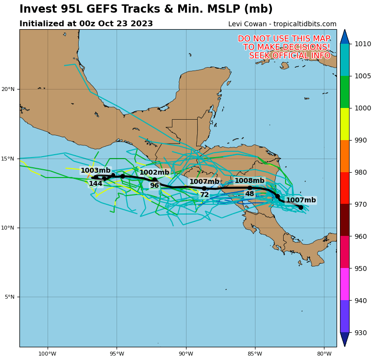
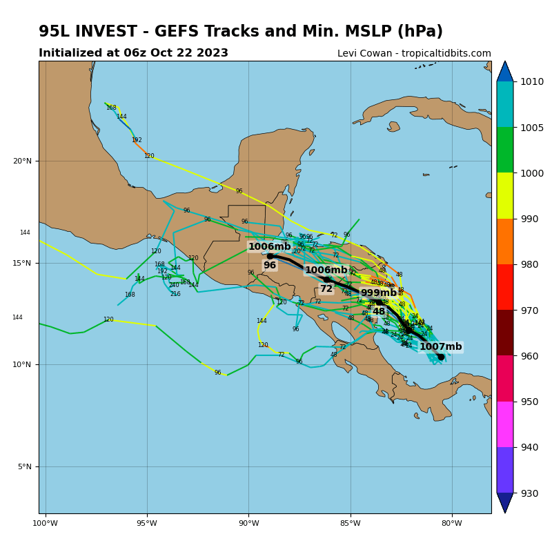
The map with all the lines is called a spaghetti model. It is where different computer forecasts say the storm is going to move. As you can see, the forecasts are all over the place, but most of them say it will drift to the northwest. That is why our forecast is for more rain midweek. If it ends up moving due west out into the Pacific, our rainfall forecast will decrease. Right now we’re also looking for winds from the east to 12-20 mph and seas at 3 feet Tuesday and Wednesday. There is quite a bit of uncertainty with our forecast for the week ahead. We will know more tomorrow morning after we see which way the storm off of Nicaragua has moved. Have a great Sunday.
Good morning Bay Islands. Here are your rainfall total between midnight and 7:30 a.m.
Satellite at 7:30 a.m.
On satellite you can see scattered clouds and showers around all our islands. We’ll be dealing with scattered showers through the morning. But you can also see clear skies to our north. This afternoon we will have mostly clear skies and only a very low chance of a shower.
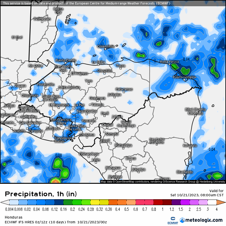
Here is a forecast map for rainfall the rest of the day. You can see how the rain moves to the south of us. West side and Utila will have a slightly better chance of midday and early afternoon showers. Winds will be out of the north around 10 mph and seas will start out 3 feet and calm to 2 feet.
Sunday we will have a 30 percent chance of a shower, mostly in the morning and late evening. Winds will be light and variable and seas at 1 foot. Starting Monday winds shift to the east at 15 mph, getting up to 20 mph in the evening, and seas will be 2 feet on Monday and 3 feet on Tuesday. Rain chances go up to 40 percent on Monday and 50 percent Tuesday through Thursday, but nothing like last week. Total rainfall predictions for next week are in the 2-3 inch range. Have a great weekend!
Good morning Bay Islands. Here are rainfall totals since midnight until just before 7 a.m.
This morning on the satellite image you can see a cold front to our north.
As you can see when you put the satellite forecast in motion, most of this wind and rain will shift to the east over the next couple of days, pushing Tropical Storm Tammy away from the Caribbean, so the effects of this front on our weather will be minimal.
Satellite at 7 a.m.
On the close-up satellite at 7 a.m. today, you can see some scattered showers around us, but also some clear skies to our north. Today we will have partly to mostly cloudy skies and scattered showers throughout the day. Winds will be from the west/northwest at 10-15 mph and seas at 3 feet, especially on the north side. Tomorrow looks like a nice day with about a 20-30 percent chance of rain, mostly in the morning. Winds will be from the north 5-10 mph and seas 2 feet. Sunday looks partly cloudy to mostly sunny with only about a 20 percent chance of a shower. Winds will be very calm and seas 1-2 feet. Monday afternoon winds shift around to the east and our rain chance goes up, though there is a lot of disagreement among the weather models as to how likely rain is next week. Have a great Friday!
Good morning Bay Islands. Rainfall since midnight. Most of this came before 3 a.m.
Today is the day things start to get better. We will still have clouds and showers, but we should see some peeks of sun and rain totals should be less than we’ve had Monday through Wednesday.
On satellite we can see storms to our east that are drifting southwest, so watch out over on Guanaja. But we also see some breaks in the clouds that we haven’t seen for days. Winds are around 5 mph from the northwest and seas 4 feet on the northside. Our winds will start to turn from the west over the next couple of days at 5-10 mph and seas 2-3 feet, especially on the north side. We will have scattered showers today and tomorrow, but mostly in the mornings and evenings, with less rain during the middle of the day. Saturday and Sunday look much better, with about a 20 percent chance of rain east side and Guanaja, and 30 percent chance west side and Utila. Rain chances go back up Monday through Wednesday next week as a small system moves in from the east, but nothing like we had this past Monday through Wednesday. Have a great Thursday!