Nov. 3, 2023 video forecast
November 3, 2023
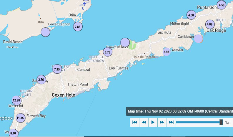
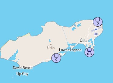
Good morning Bay Islands. Here are our rainfall totals overnight. Very consistent numbers across the big island. We’ve been a bit fortunate in this storm. Puerto Cortes has picked up over 16 inches yesterday and this morning. A bit more for Utila.
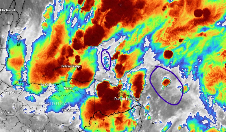
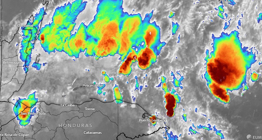
On our satellite we can see that we are in the middle of a lot of storms, though I put purple circles over areas that could give us some breaks later on today. All this activity is moving from east to west.
Winds this morning are from the north around 15 mph and seas on the north side are generally around 5 feet, though at Michael Rock Guanaja they are showing at 6 feet.
Today we will continue to have periods of rain, sometimes heavy and perhaps a peek or two of sunshine. Tonight more rain.
For the weekend we will still have scattered showers, though probably rainfall totals will be a little less than today. Monday we will have isolated showers and Tuesday through the end of the week is looking quite nice, with low winds and seas mostly 2 feet. Another good chance of rain is in the forecast for late next weekend. I’ll do a video later in the morning. Don’t forget to like and subscribe at youtube.com/@roatanweather and support us at patreon.com/roatanweather. Have a great Friday and stay safe!
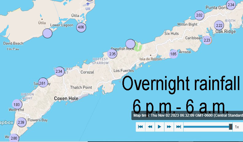
November 2, 2023
Good morning. Here is the rainfall from midnight to 7 a.m.
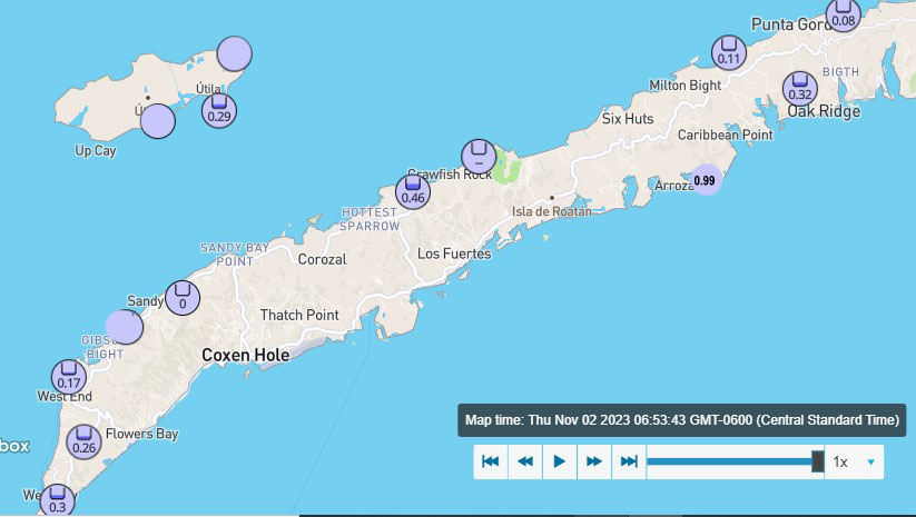
And here is the rainfall since Wednesday.
We have quite a bit of rain to our north. And also scattered showers to our east. This rain is moving quite slowly to the southwest. We’re still looking for periods of heavy rain today, tonight, tomorrow and tomorrow night. Heavier amounts should still be on the west side of Roatan and Utila. An additional 4-6 inches is forecast. Winds should pick up from the north tonight and tomorrow and the closer the wind gets, the wavier it will get on the north side. Seas right now are 4 feet at Michael Rock, Guanaja and at Camp Bay. They are 3 feet Sandy Bay and Utila. Forecasts still predict 6 foot seas this evening and tomorrow.
Rain should be less Saturday midday through Sunday though we will still have scattered showers. Starting Monday we will have lower rain chances, around 30 percent each day, and calmer winds and seas. The rain for the following weekend is not looking so bad and definitely nothing like this system. Have a great Thursday!
November 1, 2023 evening update

The 6 p.m. update lowers the likelihood of a tropical storm to 30 percent and moves the box south to Nicaragua, Costa Rica or Panama (!). No tropical storm for us this weekend. We are still looking for heavy rains and seas from our norther tomorrow and Friday.
On our satellite we can see that we are in the middle of a lot of storms, though I put purple circles over areas that could give us some breaks later on today. All this activity is moving from east to west.
Winds this morning are from the north around 15 mph and seas on the north side are generally around 5 feet, though at Michael Rock Guanaja they are showing at 6 feet.
Today we will continue to have periods of rain, sometimes heavy and perhaps a peek or two of sunshine. Tonight more rain.
For the weekend we will still have scattered showers, though probably rainfall totals will be a little less than today. Monday we will have isolated showers and Tuesday through the end of the week is looking quite nice, with low winds and seas mostly 2 feet. Another good chance of rain is in the forecast for late next weekend. I’ll do a video later in the morning. Don’t forget to like and subscribe at youtube.com/@roatanweather and support us at patreon.com/roatanweather. Have a great Friday and stay safe!
Rainfall for October 2023
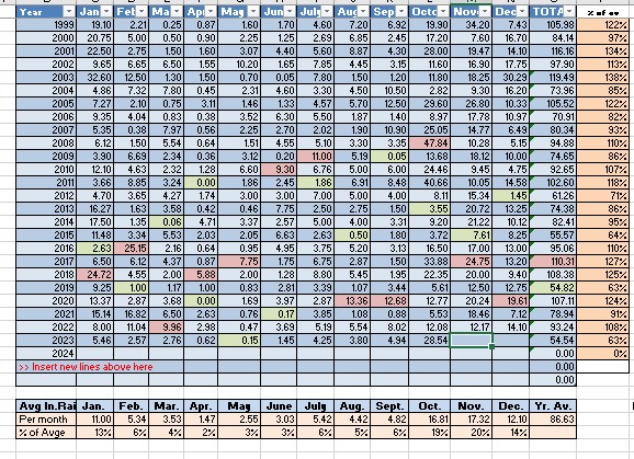
Rain total for October 2023: We are officially entering 28.54 inches in the record books for the month and that was about average across the island. From January to September we got exactly 26 inches. In October we got more than that. Our rainfall went from 30 percent of the year’s average to 63 percent. And of course the vast majority of that rain came in a five day period during our first norther midmonth. November has, on average 17 inches of rain. We definitely should beat that, with a big chunk of that coming in the first four days of the month.
November 1, 2023
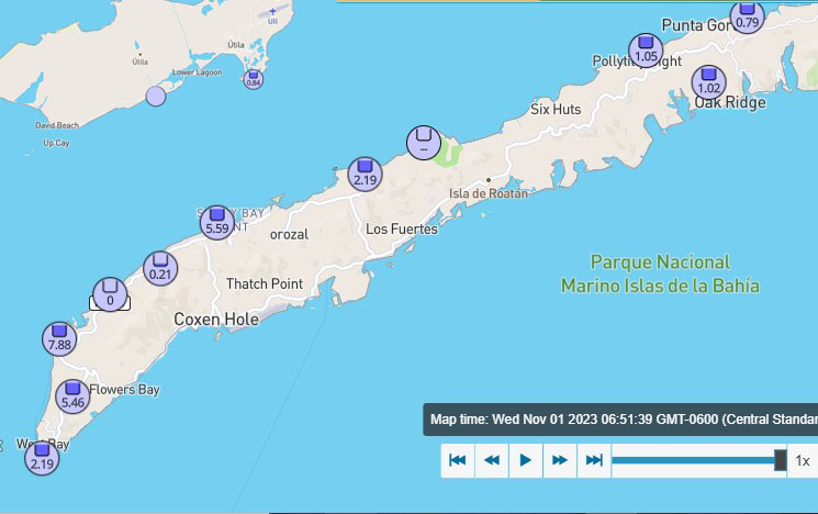
These totals are since midnight. Yesterday the west side got an additional 3 inches and the east side most of us got 2 inches.

You can see a storm just to our northeast that brought all the rain.
Rain today.
More rain tomorrow.
The most rain tomorrow night into Friday.
Seas will be 2-3 feet today with west winds.
Winds shift to the north tomorrow at 5-10 mph and seas 5 feet on the north side.
Friday should be the windiest day with north winds gusting up to 30 mph and seas around 8 feet on the north side.
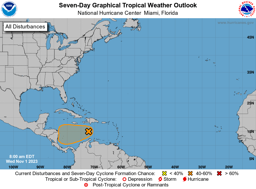
What could be Tropical Storm Vince did not get more organized last night. The National Hurricane Center lowered its tropical depression probability to 50 percent.
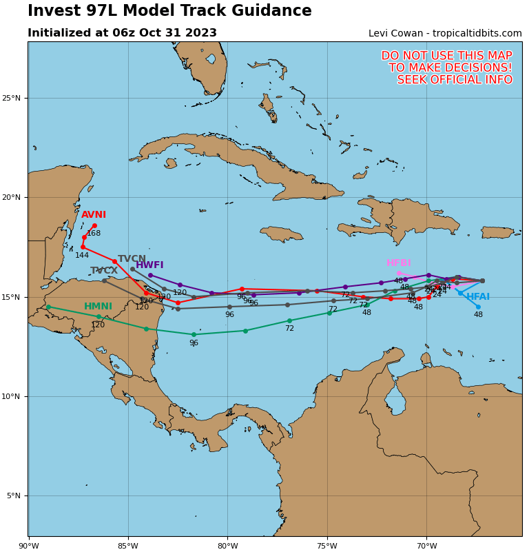
Whatever it becomes, most models show it striking Nicaragua sometime Saturday but several models bring its moisture our way Saturday night and Sunday with more heavy rain. Monday and especially Tuesday look a little nicer. Rain predictions through Friday are for another 6-8 inches and what we get this weekend depends on where our storm goes. Have a great Wednesday!
October 31, 2023
Good morning Bay Islands.

We’ve had some heavy rain islandwide already, especially on the west side, with West End and West Bay already picking up 3 inches between 6 and 9:40 a.m.
Today we will have some rain.
Tomorrow we will have more rain.
Thursday and Friday we will have the most rain.
Most models say between 4 to 8 inches, and that is just from the norther.
Saturday and Sunday our forecast depends on what happens with the potential tropical storm.
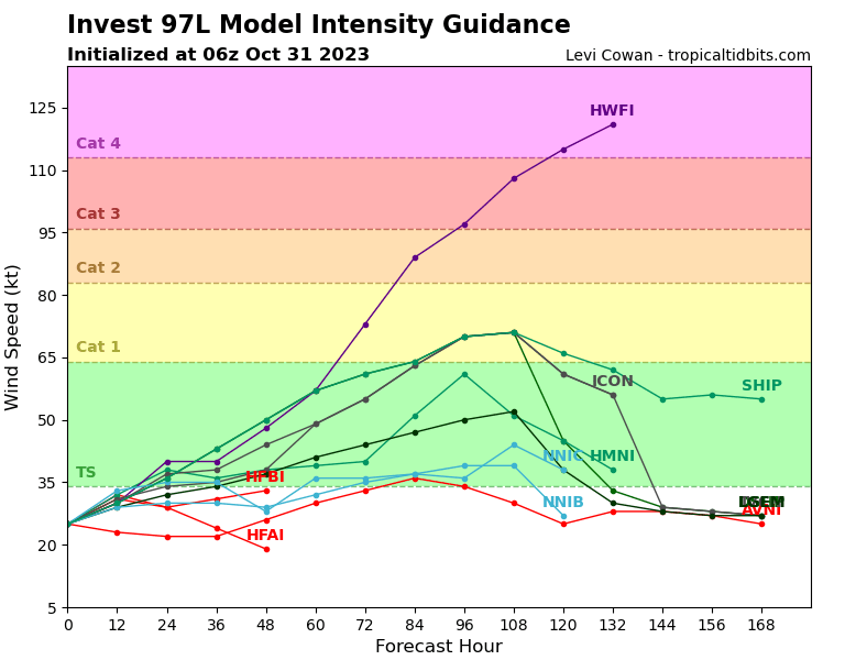
Most of the forecasts are saying the storm currently south of Puerto Rico will become a tropical storm and not a hurricane. (Let’s hope that HWFI is terribly wrong)
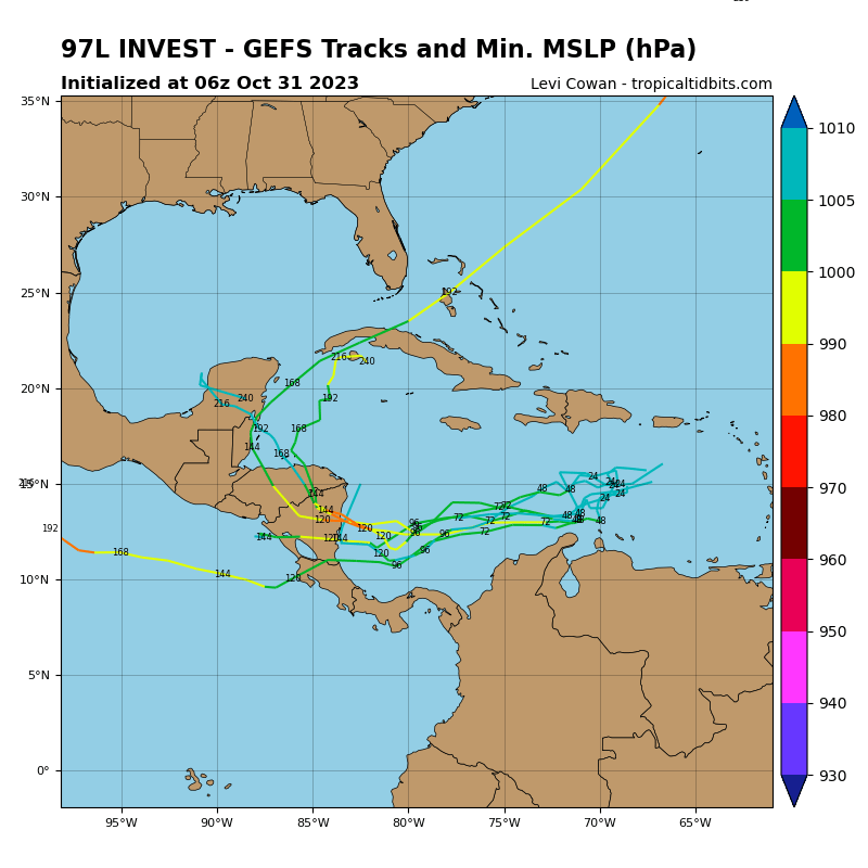
Many of them say it will strike Nicaragua,
but the GFS says it will strike near the Nicaragua/Honduras border and bring us a lot of rain this weekend. It is the rain, not the wind from this storm I’m really worried about. A lot of rain this weekend will mean more landslides. The soil is already soft, which was not a problem with the last norther.
Unfortunately we’re looking at ANOTHER norther for the end of next week as well. Have a great Tuesday!
October 30, 2023 evening update
I did a video update that focuses on wind. Friday looks to be an especially bad wind day with seas on the north side around 6 feet.
October 30, 2023
Good morning Bay Islands. I did a Facebook Live for the forecast today. I apologize for the poor graphics. We’re having a power outage on Jonesville Point and I had to use a backup computer.
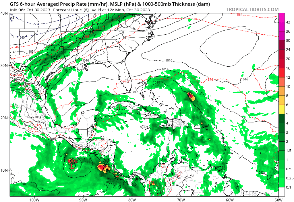
This is the GFS computer prediction from now until Tuesday. You will notice it shows the storm becoming a category 2 or 3 hurricane and hitting the Mosquito Coast of Nicaragua, but also bringing a wave of rain over us late in the weekend. This is the strongest of the models, but most of them show something going into Nicaragua this weekend.
We will have nice weather today. A small chance of rain tomorrow. A 60 percent chance of rain on Wednesday and heavy rain on Thursday, Friday, and probably Saturday and Sunday. How much rain we get this weekend depends on how strong our tropical storm gets and where it hits.

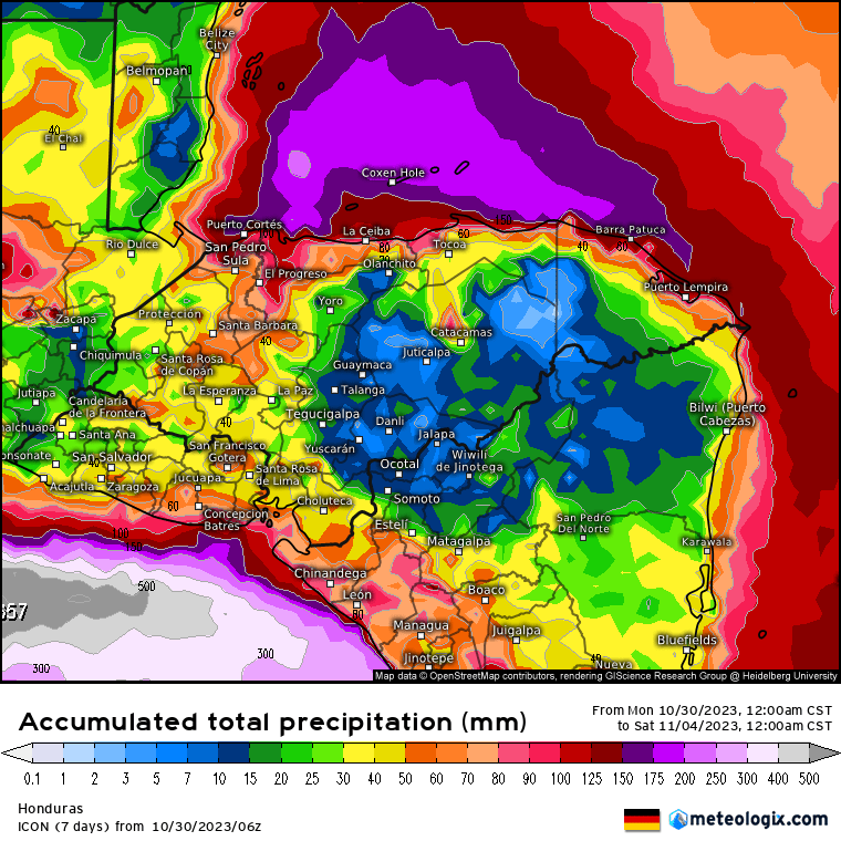

These are the rainfall models through midnight Friday night/Saturday morning. 25 mm = 1 inch. This forecast is for 4-8 inches Wednesday through Friday. This is just the norther, not the tropical storm. If we get a tropical storm/hurricane hitting the Mosquito Coast we will get further rain this weekend and into Monday, perhaps double these amouts.
If you live down a long dirt road, you may want to stock up today and tomorrow and perhaps Wednesday (though there’s a good chance of rain Wednesday) before the heaviest rains hit Thursday and Friday. Also be watchful if you have an unsupported hill near your home. I expect landslides to be a problem. We’ll keep updating through the day. Take care!
