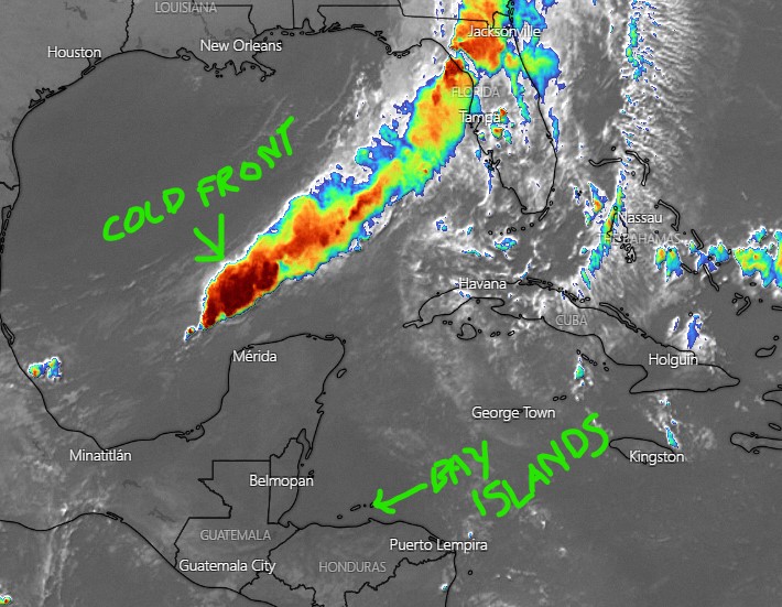
Oct. 28, 2021: Good morning, Roatan! The cold front that has been racing across the United States the last several days is now in the Gulf of Mexico and is set to pass through on Friday night bringing us a cooler weekend before rebounding and giving us a good chance of rain on Tuesday. Today we’ll have mostly sunny skies and calmerOne of the things we are most looking forward to this weekend is getting some drier air in here. In the U.S. and Canada, the temperatures vary greatly. Where I lived before coming here, in Oklahoma, the temperature in the winter could get down around 0 degrees (-18 C) and in the summer could get as hot as 110 degrees (43 C). Here the temperature has never been recorded below 65 (18C) and a well-placed thermometer (in full shade) will rarely get much above 93 (34 C). Most of the time, our temperature is in the middle 80s (30 C) which is not oppressive. What makes it feel so hot? The humidity. A good way of expressing how humid it is, is by giving the dewpoint, which is the point at which the humidity would be 100 percent. Hot air can hold more water than cold air can, so humidity is more noticeable in hot temperatures. It keep your sweat from evaporating, which is one of the main ways your body cools itself.
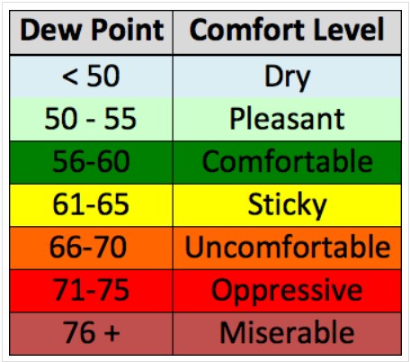
This chart says that dewpoints above 75 are miserable. Thus far in October, the LOWEST dewpoint I have recorded is 75. Most of the time during the day it is over 80. the highest I’ve recorded is 86. The temperature can never go lower than the dewpoint. So on a typical day on the island, let’s say the temperature is 85 (30 C). Not so hot right? But let’s say the dewpoint is 81 (27 C), which is pretty average. That creates a heat index (how it feels on your skin) of 101 (38 C). Pretty hot. That’s why this weekend is so exciting. Many forecasts say our dewpoints will go down to 63 (17C). This chart calls that “sticky.” But if you live on the island you NEVER feel air that dry unless you are in air conditioning (one of the primary things an AC does is dry out your house, which is as important as cooling it). Enjoy!