Nov. 27, 2021: The most remarkable thing about yesterday’s rain was how cold it was. During a downpour around noon, my temperature was 72 degrees (22 C) which I’m pretty sure is the lowest daytime temperature I’ve ever had.
From 7 a.m. to 7 a.m., the rainfall totals were 1.3 inches in West End, 2.15 in Sandy Bay SOL, 1.47 Sandy Bay, 1.35 Coral View, 1.16 in Politilly and here on Lucy Point .82.
There are definitely some showers around, especially to the west of the islands, and they are generally moving this way, so we’ll definitely keep a chance of rain around for this morning, but shies should clear in the afternoon. Northeast winds will be at 10 mph and seas at 2 feet (.6 meters). Sunday will be a nice day for Honduras’ election (this is true for the island, but also nationwide.) with winds and seas quite calm. Monday a small chance of morning rain returns with north winds at 5-10 mph and seas 1 foot. Thursday through Saturday rain chances increase again. Have a great weekend!
Nov. 26, 2021
Nov. 26, 2021: It’s been a rainy night. In the last 24 hours as of 7 a.m. West Bay had 2.2 inches, West End 1.7, Sandy Bay 1.41, Coral View .85, First Bight. 40, Politilly .63, and Lucy Point .43.
Winds will be out of the west today at 8-15 mph and seas on the northside will get up to 3 feet (1 meter). Rain will be possible throughout the day. Rain should end Saturday morning with northeast winds at 10 mph and seas falling to 2 feet (.6 meters) on the north side. Saturday afternoon through Sunday look quite nice, with calming winds and seas through the weekend. Monday we’ll have a chance of morning showers and Tuesday a smaller chance of morning showers, but mostly pretty nice conditions.
Nov. 25, 2021
Nov. 25, 2021: We awoke to one of the coolest mornings of the year. West End and Sandy Bay reached 68 and we reached 69 on Lucy Point (both equal to 20 C). That isn’t far from our all-time low of 65 (18 C). Midday downpours yesterday gave most of us between a quarter and a half inch of rain, though West End got 1.3 inches.
This morning will be nice, with partly cloudy skies and light winds and seas around 2 feet (.6 meters) on the north side. This afternoon clouds will increase and so will the chance of rain. Heavy downpours are likely tonight and through the day tomorrow. Many models give us two inches tonight through tomorrow. Winds and seas will also increase tomorrow at 12-17 mph from the north and seas at 3 feet (1 meter). Rain chances linger into Saturday morning, but after those clear out, the weekend should be nice, with winds and seas getting calmer.
Nov. 24, 2021
Nov. 24, 2021: Good morning, Roatan! That was definitely a big downpour for most of us yesterday morning, and a few of us got a shower this morning around 4 a.m. Rain totaled .80 in West Bay, .59 in West End, a little over an inch in Sandy Bay, .22 in Coral View, .92 in First Bight, .35 in Politilly, and .47 here in Lucy Point.
We are definitely on the other side of the front, with dewpoints this morning getting as low as 68 (20 C) and temperatures down around 71 (21.6 C) at their coolest. At 7 a.m., most of us are in the mid-70s (around 24 C).
We have a lot of low clouds around and there are some showers on radar to our north. We can’t rule out a passing shower today, but we should have clearer skies this afternoon and light north winds around 5-10 mph and seas around 2 feet (.6 meters) mostly on the north side. Tomorrow looks pretty nice as well, but tomorrow night through Friday and into Saturday morning looks pretty rainy. Sunday looks nice, with only a small chance of a shower on Honduras’ election day. Have a great day!
Nov. 23, 2021
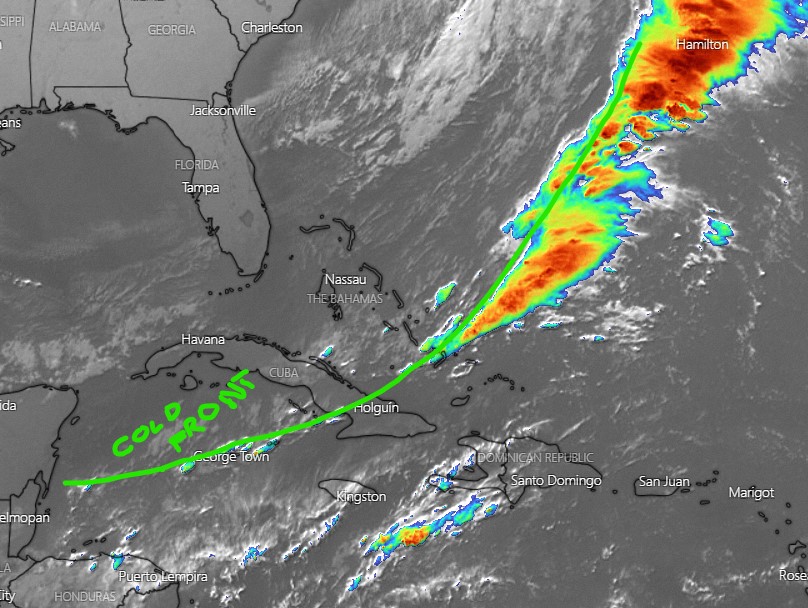
Nov. 23, 2021: Depending where you were yesterday you either got real wet or got nothing. In the last 24 hours ending 7 a.m. today West Bay got .42 of an inch, West End .65, Sandy Bay SOL 1.65 (though the other Sandy Bay station only got .19), Coral View .04, First Bight 1.6, Politilly .84, and here on Lucy Point .43. Most of ours came around midnight, but many locations got a good afternoon rain yesterday.
Our satellite image shows our end of the cold front is much weaker than we expected. That would lead me to believe that our rain threat is lower than the models indicate for today. They still say our north winds should get a little stronger this afternoon and they still want to give us a chance for an afternoon shower. I’d put it at about 40 percent. Rain chances go way down tonight and tomorrow.
Rain chances also look low for the U.S. holiday on Thursday. Winds will be out of the northeast at 10 mph with 2 foot (.6 meter) seas on Thursday. There are no major storms in our forecast through the end of the week, but we can’t rule out a passing shower, especially Friday and Saturday. Have a great Tuesday!
Nov. 22, 2021
Nov. 22, 2021: We got .02 of an inch of rain last night, though it seems most people didn’t get anything. At 7:30 a.m. we have rain showers to our northwest, so we’ll see if they hold together, they would mostly bring rain to the west side of the island this morning.
Today we will have a decent chance of rain throughout the day and winds 7-12 mph from the west/northwest. The front arrives tomorrow and that is when we should have the most rain. Tomorrow looks like a pretty rainy day with north/northwest winds 10-20 mph and seas getting up in 2-3 foot range (.6 to 1 meter) on the north side. Wednesday should be a nicer day with about a 30 percent chance of a passing shower. Thursday should still be cool, but rain chances return, especially in the afternoon. Those rain chances last into Friday morning, but the weekend looks drier. Have a great week!
Nov. 21, 2021
Nov. 21, 2021: The models definitely missed the clouds and rain we got yesterday. That’s the thing about the forecasting biz, sometimes you get a big miss and that’s what we had yesterday. Rain totals were around an inch islandwide, though less in Sandy Bay (around a quarter inch) and more in First Bight (1.61) and West Bay (1.35)
We have clouds and rain between Utila and Belize this morning, but fairly calm winds and seas.
The chance of rain will be fairly low today and morning clouds should give way to afternoon sun. The chance of rain increases through the day tomorrow. Tuesday looks like the highest rain chance of the week.
Winds today will be fairly calm, but what winds we have will generally come from the west at 3-7 mph. Tomorrow winds will start out from the west and turn to the northwest with the approach of our cold front. Tuesday winds will be from the north/northwest at 10-15 mph. Rain chances come down slightly on Wednesday and but go up again on Thursday. I know a lot of people want to know what the weather will be like Thursday, but this week’s forecast is pretty difficult since a cold front is stalling just to our north and models disagree as to exactly where it will park. We definitely should get some cool air this week.
Nov. 20, 2021
Nov. 20, 2021: Good morning Roatan! We have a nice weekend in store for us — mostly sunny skies, winds light and variable and seas at 1 foot (.3 meters). Nice conditions will continue through Monday morning. Monday evening, winds should start picking up a little from the northwest and there will be a good chance of showers Monday night into Tuesday. Rain chances right now look to continue into Thursday morning, but on Thursday it looks like we might get a pause in the rain with a cool north wind, so all in all a nice day for the U.S. holiday. I know a lot of locals may be starting to think of weather on the Honduran election day Nov. 28. The long-range forecast calls for nice weather that day. Have a great weekend!
Nov. 18, 2021
Nov. 18, 2021: Finally a chance to dry out! We should have partly cloudy skies with east winds a little higher than we’ve been used to, around 12-17 mph and seas 2-3 feet (.6 to 1 meter). Today through Sunday chances of rain will be very low and mostly at night.
Winds should calm a bit tomorrow at 5-10 mph and seas at 1 foot.
Clouds will start increasing Monday as the next cold front nears. Tuesday and Wednesday look rainy and the front may pass through making next Thursday nice a cool with a lower chance of rain.
Nov. 17, 2021
Nov. 17, 2021: Good morning, Roatan! Most locations have gotten decent rain over the last 24 hours. On Lucy Point we got an inch yesterday and about a half inch this morning. Utila reports 1.8 inches but other locations have gotten less — .4 of an inch in First Bight and only .2 of an inch in Camp Bay.
Today we maintain a chance of rain, but perhaps less as the day goes on and hopefully more sun than yesterday. Thursday and Friday the chance of rain stays low and will mostly be at night. Winds today will turn around and start coming more from the east at 7-12 mph, which will lower the waves on the north side and raise them on the south side. We’ll stay around 2 feet on the waves (.6 meter). This weekend still looks pretty nice. Rain chances increase first of next week. A lot of folks have been asking about U.S. Thanksgiving next Thursday. It definitely looks cool, as the cold front will have passed over. It is still too early to say whether it will be clear or whether we will still have some clouds and misty rain. Have a great Wednesday!
