March 29, 2023

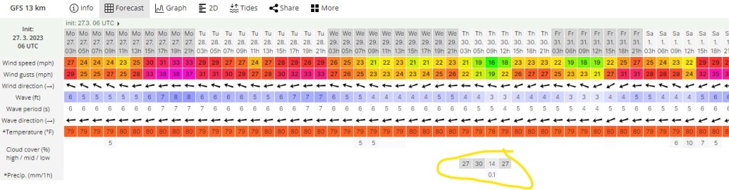
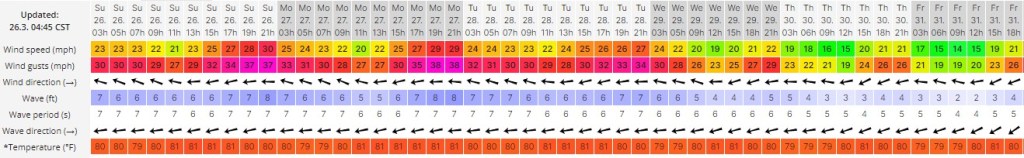
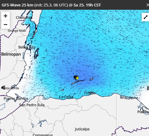
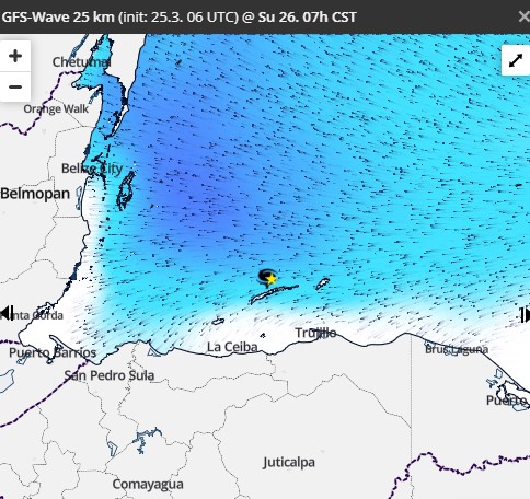
March 29, 2023: Good morning Bay Islands! Last night we got up to 35 mph winds. That might sound windy, but it was about 5 mph less than the previous night. So we are headed in the right direction. Today we should be slightly less windy with daytime winds 20-25 mph and seas at 4 feet and nighttime winds, especially after midnight, falling to 15-20 mph and seas to 3 foot seas for the morning yacht.

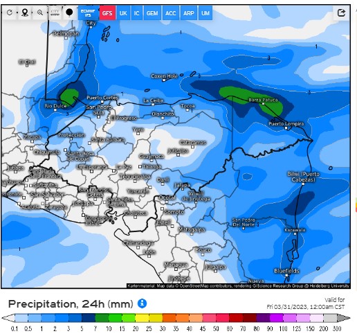
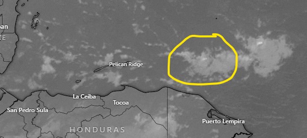
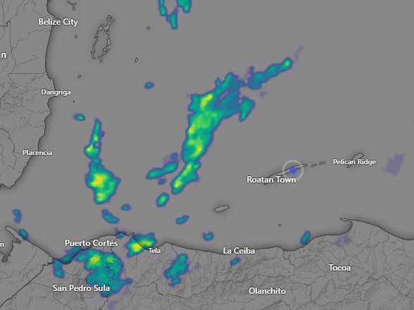
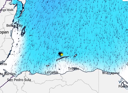
Tomorrow we also have a small chance of a morning shower. I’m including tomorrow’s rainfall prediction from the US GFS computer model. You will notice a pretty typical setup for morning showers this time of year, with the rain starting off the Mosquito Coast and drifting toward us. As the morning continues, these showers weaken and the question is whether any of them will make it to the islands. Let’s hope.

Starting Friday night we go back to being dry, windy and wavy. Those conditions will continue through the holiday week next week. For the holiday weekend long range models are saying the winds might calm a little and we might have a few scattered showers.

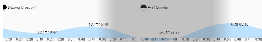
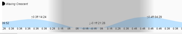
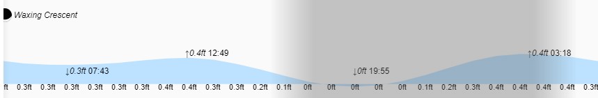
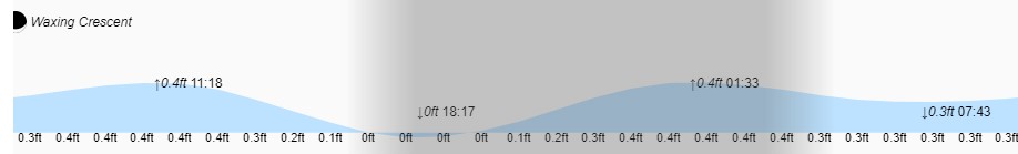
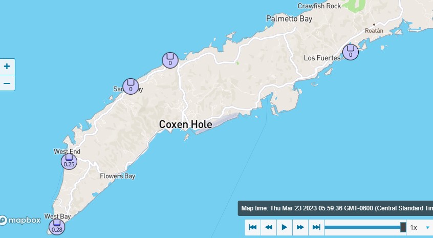
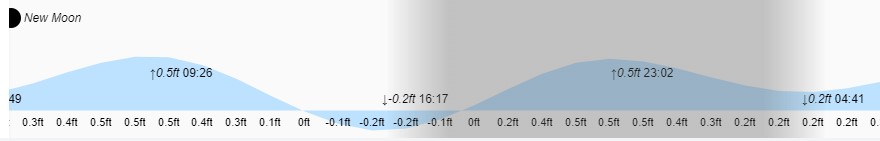
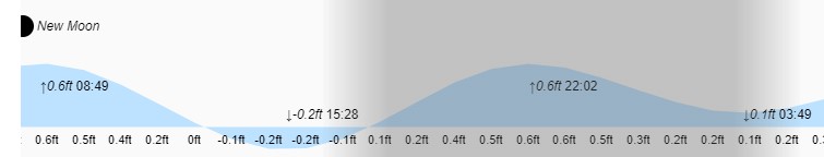
Low tides are 11:23 a.m. and 11:09 p.m. Have a great Wednesday!

March 28, 2023

March 28, 2023: Good morning Roatan! We are still windy with 25 mph winds after getting up to 38 mph last night. Someone higher up the hill than we are got up to 45 mph. Seas are at 5 feet around the island. Today and this evening will continue super windy, but tomorrow starts three days when our winds are more normal. Tomorrow’s daytime winds should be 20 mph with 3 foot seas, tomorrow night winds will be 25 mph and 4 foot seas. Thursday winds will be 15 mph and 2 foot seas and Thursday night 20 mph and 3 foot seas. Also on Thursday we will have a small chance of a morning shower. It’s not much, but it’s the only chance we see for at least a week and a half. Friday should be nice, but Saturday the winds come back in full force.

Low tide is 10:27 p.m. Have a great Tuesday!

March 27, 2023

March 27, 2023: Good morning, Bay Islands. Another windy night with a peak gust of 39 mph and seas up to 6-7 feet. This morning seas on the south side are 5 feet and today looks like it will be just as windy as yesterday. We are still looking for a little bit lower winds Wednesday through Friday with 20-25 mph and seas 3-4 feet.

I don’t want to give anyone false hope but Thursday there may be a few clouds and maybe one or two showers around the islands. Otherwise we are clear and dry into next week.

Low tide is 9:28 p.m. Have a great week!

March 26, 2023

Good morning Bay Islands. Seas are down to around 5 feet this morning on the south side and winds are 25-30 mph this morning from the southeast. We had a peak gust of 39 mph last night and seas got up around 7.5 feet (2.2 meters). Get ready for more of the same, gusty winds, especially after sundown, and extremely choppy seas in the evening, a little better in the morning.

This is the wind and wave forecast from windguru.cz. As you can see our weather will be about the same until midweek. Wednesday through Friday with winds 15-25 mph and seas 2-4 feet. Unfortunately after that the wind goes up again. No rain and very few clouds in the forecast.

Low tide is 7:55 p.m. Have a great Sunday!

March 25, 2023

March 25, 2023: Good morning Bay Islands! Welcome to our new windy reality. Seas on the south side are 4-5 feet after getting close to 7 feet overnight. Seas near the reef on the north side are more moderate at 2-3 feet. We will have clear skies and no rain today tomorrow and the following week. Winds will be their strongest tonight after sunset at 30-35 mph from the east.

Here’s the wave map for 7 p.m. tonight. Dark blue indicates 6-8 foot seas. This evening’s ferry ride will be rough all the way from Ceiba.

Here’s the wave map for 7 a.m. tomorrow. You will notice tomorrow morning things are a little better toward Ceiba. Winds will get A LITTLE better starting Wednesday.

As you can see on the tide chart, tides have moderated from what they were a few days ago as we enter crescent moon phase. Low tide is 6:17 p.m. Have a great weekend!

March 23, 2023

March 23, 2023: Good morning Bay Islands! Early this morning West Bay and West End got a couple of rounds of rain, good for a quarter of an inch. The rest of the island stayed mostly dry.

Satellite at 6:15 a.m.

There are clouds around this morning, so we will keep a chance of a morning shower. I’ve circled in yellow an area of clouds well to our east. Most of the time these disappear in late morning, but if they hold together and don’t move to our south, it may give us a small chance of rain late in the morning.

This morning seas are 3 feet on the southside and 2 feet on the northside. Winds are still fairly calm, but we definitely expect them to start blowing harder from the east, giving us 4-5 foot waves tonight, 5-6 foot waves tomorrow night and 6-8 foot waves Saturday night. Daytime wave will generally be about 2 feet less than the nighttime waves. In other words be careful out on the sea.
We are entering a period of extremely dry air overhead, so we will see fewer and fewer clouds in the days ahead.

Low tide is 4:17 p.m. Have a great Thursday!

March 22, 2023

March 22, 2023: Good morning, Bay Islands! Most of us got a little rain early this morning.

Radar image at 7 a.m.

There are a few clouds around the island so we will keep a small chance of a passing shower through the morning hours, but we should soon clear out.

Tonight and tomorrow morning there is maybe a 10 percent chance of rain and after that there is basically no chance of rain for probably a couple of weeks. Winds are from the east at 15 mph and seas 4 feet. We are going back into a windy cycle with daytime winds 15-20 mph and seas 3-4 feet and nighttime winds 20-25 mph and seas 4-5 feet. This weekend nighttime winds will be even stronger, around 30 mph.

We are still in the new moon period of strong tides, so low tide at 3:28 p.m. will be about 3 inches below a normal low tide. Have a great Wednesday!

March 20, 2023

Rainfall as of 6:45 a.m.

Good morning Bay Islands. About 1 a.m. the west side got a heavy downpour of an inch and a half. Most of the rest of the island and Utila have stayed dry as of 6:45 a.m.

Radar at 6:45 a.m.

There’s lots of rain around, mostly to our west. These showers are moving to the south. There’s a good chance we get some rain in the next couple of hours, especially Utila and the west side.

Wave forecast for 7 a.m. Tuesday

Throughout the day, seas will get higher on the north side. Our north winds are not very strong, but they are stronger out to sea and will kick up the surf. Seas are expected to get up to 5 feet on the north side. As you can see on this map for the seas at 7 a.m. tomorrow, seas will be calmer on the south side and heading toward Ceiba, perhaps 2-3 feet.

Our best chance of rain will be this morning. This afternoon we’ll have a mix of sun and clouds and scattered showers. Another good chance of rain tonight and early tomorrow morning. After that our chance of rain is lower for tomorrow, tomorrow night and Wednesday, maybe a 30 percent chance. After that the chances of rain pretty much go away. Starting Wednesday we have dry conditions and strong east winds kicking up our seas. Have a great Monday!

March 19, 2023

March 19, 2023: Good morning, Bay Islands! This morning we awake to cloudy skies, a moderate west wind and seas at 3 feet. Because our winds are generally from the west, West Bay Beach is a little wavier than usual.

We had clouds with some thunder move down from the Yucatan last night, but there wasn’t a whole lot of rain. Utila got .06 and Sandy Bay got .01. If you got anything let me know in comments.

The cold front is in the northern part of the Yucatan and will get closer as we go through today.

Today we should have some sun and some clouds and a small chance of rain. Winds will be from the west at 10-15 mph and seas 2-3 feet, especially on the north and west sides. Tonight, through the day tomorrow and tomorrow night we have a lot of clouds and a very good chance of rain. Most models are giving us between 1-2 inches of rain. Let’s hope we get it, because after that the forecast is very dry. Tomorrow we will have north winds at 10 mph and we should be cool, in the upper 70s to around 80. Tuesday winds will turn to the east at 12-17 but because the winds north of us will be stronger, our seas will be up to around 4 feet. Rain should be less on Tuesday, but there will be scattered showers around through Tuesday night. Wednesday morning and Thursday morning there are small chances of showers, but after that we turn dry and windy, especially for the following weekend. Have a great Sunday!

March 18, 2023

March 18, 2023: Good morning, Bay Islands. We awake to light winds and 3 foot seas. Winds will remain light today and seas will be 2-3 feet. We will be dry, but there is an approaching cold front in the Gulf of Mexico that will weaken as it gets close to us. It will bring us a very small chance of rain on Sunday, but better chances Monday and Tuesday. It may hang around to give us small chances of morning showers Wednesday and Thursday. Winds tomorrow will be from the west 10-15 mph and seas at 3 feet. Winds and seas Monday will be very calm. Tuesday into Wednesday we start getting the east wind back and by the end of the week it will be drier and windier. Have a great weekend!