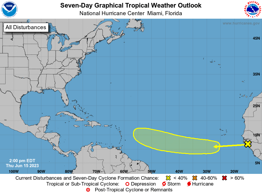
June 9, 2023: Good morning Bay Islands. Yesterday the airport had a high of 93F (34C) with a heat index of 110F (44C). That’s back to the kind of heat we had before our big Sunday night storm. I’ve been forwarded posts from divers with reading around 90F underwater. The automated buoys are right around 86F (30C) on the surface and 85F 14 meters deep.
We have another couple of days of calm winds and seas. Again, this has been one of the longest calm periods I can remember, but it is coming to an end. We’ll start seeing a little of that Sunday with winds 15-20 mph and seas around 2 feet. Then getting into Monday we’ll see nighttime winds around 25 mph and daytime winds around 20 mph. Seas will be around 4 feet (1.3 meters), getting up to 5-6 feet by midweek.
Through most of next week we’ll have a small chance of overnight showers. We’re still very hopeful that around the 17th or 18th we’ll get a tropical wave that will bring us a very good chance of showers. That would cool things off and give us some much needed rain. Let’s hope it happens. Low tide is 11:50 a.m. Have a great Friday.
June 8, 2023
Good morning Bay Islands. Yesterday we had a high of 90F (32C) and a heat index of 103F (39C) at the airport. That’s hot, but not quite as hot as the high of 94F (34C) and heat index of 110F (43 C) before the storm Monday night. Sea temps have also cooled a bit to just under 30C (86F), but the longer we go without rain, those temps will creep up again. And the rest of this week definitely looks dry and calm.
The following week looks quite a bit windier, with nighttime winds up to 25 mph and seas to 4 feet (1.3 meters). Next week we should have small chances of overnight showers.

I’m including a forecast map of the weekend of the 17th, because the GFS is predicting a wave of moisture that weekend. It wants to spin a tropical system into the Gulf of Mexico after that, but for our purposes, we really hope this wave of moisture happens, because it would give us some much-needed relief. But it is a long way off and no forecast a week and a half out is very reliable. Have a great Thursday.
June 7, 2023
June 7, 2023: Good morning Bay Islands. We got a little windy yesterday afternoon, but we should be much calmer today through the end of the week. Winds will be from the northeast at 5-10 mph and seas 1-2 feet. We will also be dry through the weekend, with a chance of an overnight shower returning Monday night. Monday is also when our easterly trade winds return with 20-25 mph winds and seas around 4 feet. Have a great Wednesday!
June 6, 2023

June 6, 2023: Good morning Roatan. We are all happy it rained last night but let’s spare a thought for Larry Rapp’s banana tree in West End that met its end in last night’s storm. I recorded a peak gust of 36 mph. A couple of folks, including Larry in West Bay, have reported over 3 inches in their rain gauge. The most an electronic gauge picked up is 2 inches, in West Bay and Politilly.
Here is the radar, starting at 8:15 p.m. last night and continuing to 8:15 a.m. today. You will notice at the end, it shows the core of the rain over Santa Helena and Guanaja. Lisa Garcia in Guanaja tells us she got .8 of an inch and it continues to rain this morning. There is rain to our west and the general movement of the rain is to the north. We will keep a chance of rain through the day, but especially this morning.
Today should be mostly cloudy with perhaps an occasional shower. Winds will be from the east 10-15 mph and seas around 2 feet. Tonight and tomorrow night there will be a small chance of an overnight shower. Tomorrow during the day through the rest of the week will be fairly calm and dry.
The chance of rain goes up this coming Monday, and the wind finally returns next week.
I want to warn you that you may start getting scary Whatsapp messages because the GFS computer model is trying to predict a tropical storm forming in our area in two weeks. First, this is way early in the season for a tropical storm to be forming around here. Second, computer models two weeks out are extremely unreliable, so I doubt there’s anything to worry about, but we’ll keep an eye on it. Low tide is 4:50 p.m. Have a great Tuesday!
June 5, 2023
Tonight and tomorrow morning we start looking for decent chances of rain. We have those chances again tomorrow night and Wednesday night. Starting Thursday things look a bit drier again into the weekend. Even if we don’t get much rain, the clouds and nearby rain should bring a LITTLE relief from the heat. We deserve it. Today it is already 89F (31C) with a heat index of 102F (39C) at the airport at 7 a.m. Low tide is 3:50 p.m. This week should be mostly calm. The long-range forecast gives us trade winds returning from the east next week.
Sea temperature discussion
I promised a discussion about our recent heat wave and its effect on sea temps. First of all, we are not alone.

The first map shows temperatures at a network of buoys operated by aqualink.org.

Yellow means the area is under a heat watch, orange means heat warning, red means coral bleaching is likely, brown means coral death is likely. There is one location in level 2, on the Pacific side of Costa Rica, which has been above bleaching temperature since late March.

We are mostly in the heat watch area since we really have been extremely hot for only a couple of weeks, and we are just now at the bleaching temperature. As you can see on the second map, one location is giving a bleaching warning, the buoy off of West Bay. A couple of days ago, the thermometer one meter below the surface reached 89 degrees (31.8C) around the island. That’s a very warm bath temperature and not a good temp for coral.

But as you can see in the last chart, which is the temperature recorded at Blue Hole, midisland on the north side, normally we get a little cooler as we move late June into July because we usually get a few more showers, that cools sea temps a bit. But the sea gets warmer as we get into late August – October. This, of course, is also our hurricane season. Right now sea temperatures are about 1 degree celsius (2 degrees fahrenheit) above this time last year. Hopefully we get some rain and cool the sea a bit, but I’m concerned as we get into late August, if we are still warm, it won’t be good for the reef and it will give more fuel to any nearby tropical storms.
June 4, 2023
June 4, 2023: Good morning Bay Islands! We wake up again to mild winds and calm seas. Today will be sunny and fairly calm, which will again make for a very hot day. Winds tonight will be from the east 10-15 mph. Tomorrow we will have a few more clouds, but we’ll stay dry until tomorrow night, when we have a decent chance of seeing some showers. Tuesday will again be mostly cloudy with west winds 7-15 mph and 2 foot seas and Tuesday night we will again have a chance for scattered showers. I’m very hopeful that we will start seeing more of these overnight showers to finally bring some relief from our drought. Have a great Sunday!
June 2, 2023
Good morning Bay Islands. We had a shower try to make it to Utila around 1 a.m. and fall apart just before it got there. Otherwise on radar we see another storm well to our north off the northern coast of Belize and one coming off the Mosquito Coast. But sadly none of them were around here.
The computers are wanting to give us a slightly better chance of a shower tomorrow morning. If we get it, it would be a quick, small rain but anything would help. We’re still watching the middle of next week for a better chance of overnight showers.
We will continue to have mild winds and calm seas. Low tide will be 1:20 p.m. and since we are coming into the full moon, it will be four inches below an average low tide. Have a great Friday!
Rainfall (or lack thereof) for May 2023

Rainfall (or lack of rainfall) for May 2023: We had one shower during the entire month, that fell on May 15. West Bay got the most, .35 of an inch, but most of us got only around a tenth of an inch. Officially we’re putting .15 of an inch the books for the month, the least rain in a single month since we recorded none in April 2020. Thus far this year we have recorded 11.56 inches of rain. That is less than half of our normal total through May of 23.89 inches.
June is normally a bit wetter than May with an average of 3.09 inches. This is a time of year we start getting a few more overnight and early morning showers. Right now the long-range forecasts give us some hope for those, especially toward the middle of the month. Let’s hope it’s right.
June 1, 2023

Good morning and welcome to June! Overnight there was a really nice storm, but it was well to our north. That would have felt really good here. There are indications that we will get one sometime in the next two weeks as we transition into what is normally a little bit of a wetter month. There are no indications that the winds and seas will pick up any time soon. This has to be one of the longest stretches of calm seas this time of year I’ve seen here.
Today and tomorrow will be partly cloudy and dry. Our next small chance of a shower comes Saturday morning. After that our next decent chance is the middle of next week. Low tide is 12:37 p.m. Have a great Thursday!