June 18, 2023

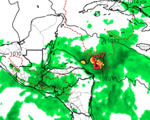
Good morning Bay Islands! Our tropical wave is on our doorstep, the question is will it be able to come in. You can see the mass of moisture centered off the Mosquito Coast that we’ve been waiting for for weeks. It is already bringing good rainfall to the Mosquito Coast and there are even a couple of showers near us on radar at 6 a.m., one east of Guanaja, one north of eastern Roatan. But for the most part, the computers say that the same mainland mountains that weaken most hurricanes before they reach us will also dry out these rain storms before they reach us.

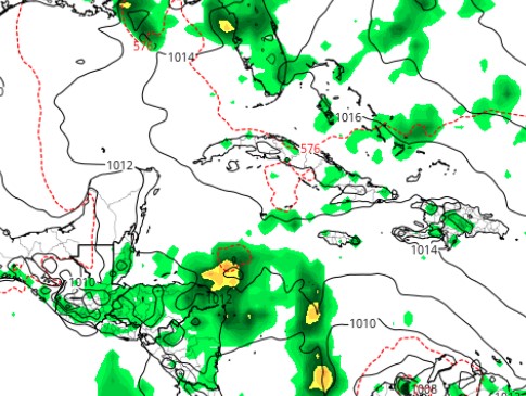
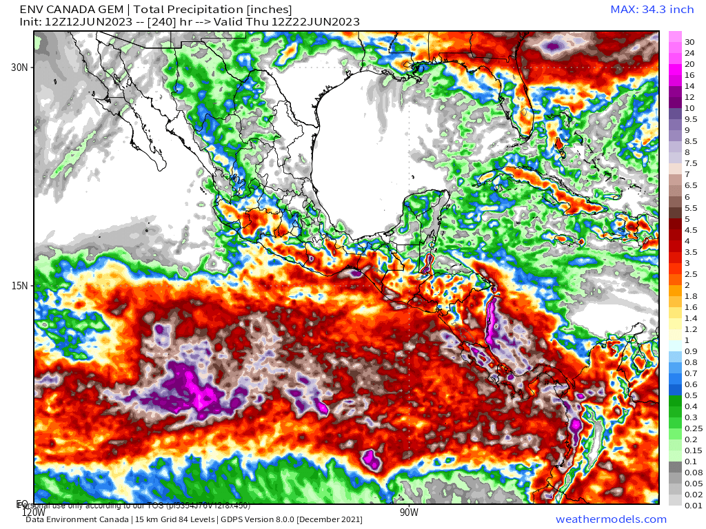
Here’s the GFS rainfall forecast through noon Friday.

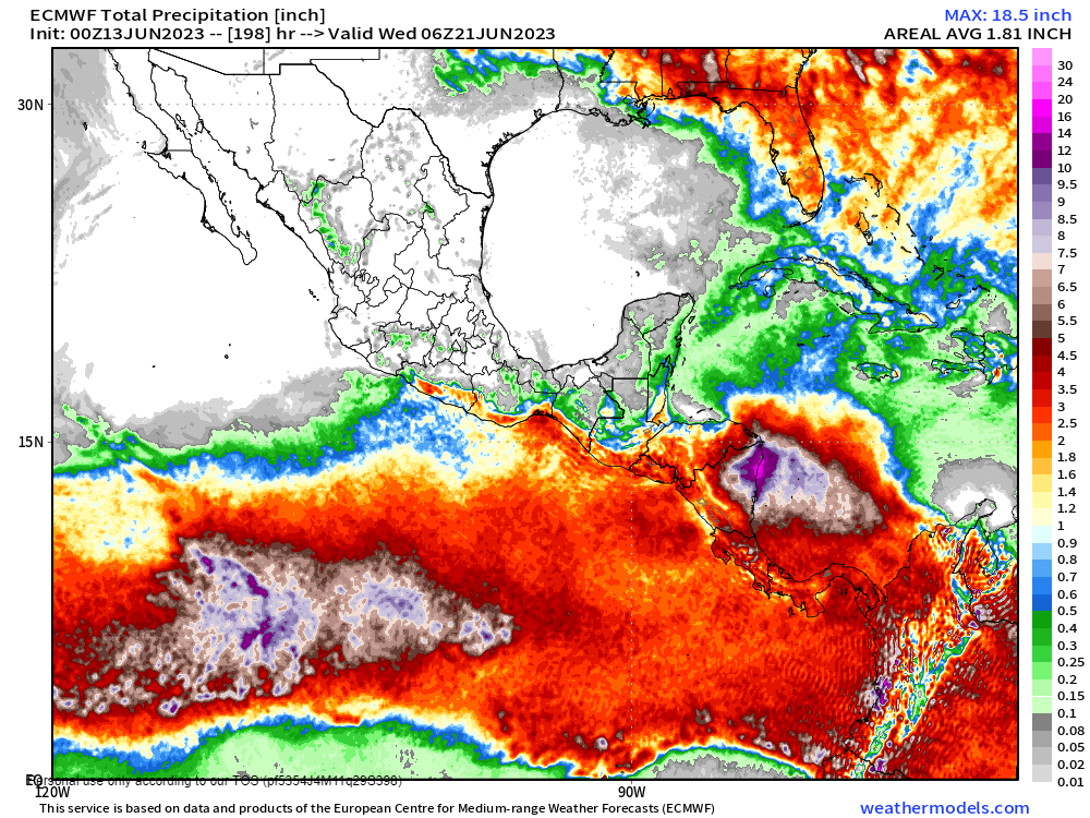
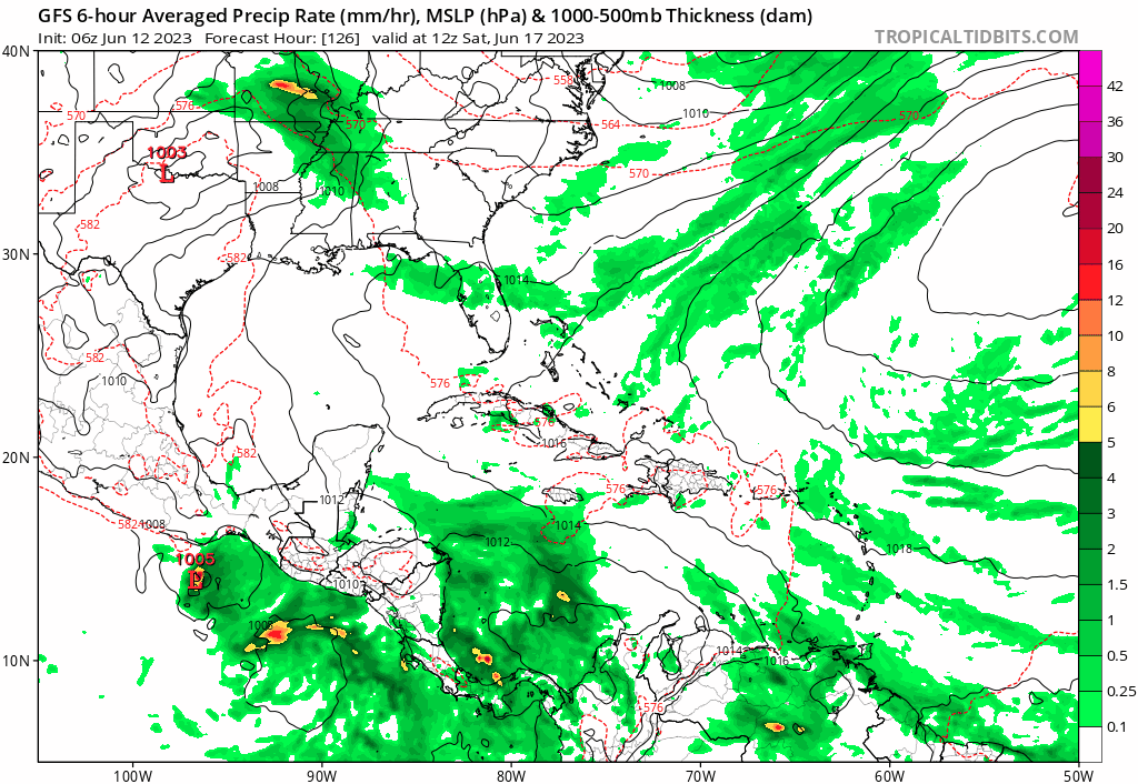
And here’s the Euro rainfall forecast through noon Friday.

You will see they leave us in a big blue hole of not much rain. Guanaja is close to a boundary that gets more rain, and I think over the next week many if not all of us will see at least a little rain. I also think that rain will be generally heavier the further west you go, so Guanaja has a much better chance than Utila. Those chances start tonight into tomorrow morning and get a little better into the middle of the week, but each day they are no more than 1 in 3.
Tonight and tomorrow night winds stay fairly strong in the 20-27 mph range. Tuesday the calm a bit to 15-22 mph and Wednesday and Thursday look a lot calmer. Low tide is 3:08 p.m. Have a great Sunday!

June 17, 2023

Good morning Bay Islands. We wake up to east winds 20 mph and seas 2 feet on the north side and 4 feet on the south side. These winds will continue through the weekend and start to calm a little on Monday.
This weekend will be dry, but we continue to hope for some rain next week.

The forecast map shown here is the GFS forecast for midnight Tuesday night/Wednesday morning. Our tropical low pressure system is shown to our east and is forecast to move north away from us. But the GFS gives us rain chances Monday through Thursday. Our best hope is that we get some scattered showers next week. These will not be rainy days, but each day there will be a 1 in 3 chance of catching rain shower. Low tide is 2:30 p.m. Have a great weekend!

June 16, 2023

June 16, 2023: Good morning, Bay Islands! We wake up to east winds at 20 mph but they got up to 39 mph last night. Seas are at 3-4 feet. Windy conditions will continue through Monday before we get some calm during the middle of next week. We are still in the midst of dry conditions and hoping for some relief with that tropical wave next week. Best rain chances right now look to be Monday and Tuesday and perhaps early Wednesday.
The GPS computer model has for weeks been trying to make a tropical storm out of this wave, but this morning it seems to have given up. Upper level winds are not good for tropical storms and tropical development is unlikely, though not impossible. Let’s still hope we get the rain. Low tide is 2:30 p.m. Have a great Friday!

June 15, 2023

The National Hurricane Center has some storms coming off the west coast of Africa with a 20 percent chance of tropical development over 7 days. Some computers are developing this, but it is more of a threat to the Eastern Caribbean and no threat to us.

The second map is the GFS forecast for midnight Monday night. It has the tropical wave that we’ve been watching for days perhaps getting close to a low-level tropical storm, but it also forecasts it to turn sharply north and away from us.

The third map is the Euro prediction for noon Tuesday. It has a much weaker storm, but it does bring the storm west instead of north. This would be good for us because it gives us a better chance of rain Tuesday through Thursday. We’ll keep an eye on it.

June 15, 2023

June 15, 2023: Good morning Roatan! We have a shower to the east of Guanaja, but unfortunately it is just sitting there and it will eventually fade away. We have 20 mph east winds this morning and 4 foot seas on the south side and 2 foot seas on the north side. Our windy conditions will continue, getting up to 30 mph in the evenings, through Sunday.
Monday things will get a little calmer as the tropical moisture gets closer to us. Unfortunately most of the models show the storms getting close, but then taking a sharp turn to the north, away from us. We still will have a chance of showers Monday through early Wednesday. Low tide is 1:17 p.m. Have a great Thursday!

June 14, 2023

June 14, 2023: Good morning Bay Islands. The wind has brought us a little relief from the heat, though the high yesterday was 91F (33C) and the heat index was 105F (41C), winds at 20-30 mph make that heat more bearable. The waves have also cooled sea temps a bit. A buoy on the north side is now under 29C (84F) after being well over 30C for awhile. We will continue with the strong east wind and waves 4-5 feet (1.3-1.6 meters) through the weekend. The middle of next week looks calmer, though not completely calm.As for rain, the expected tropical wave continues to disappoint. Our best shot of rain will be Monday, but it is still not a sure thing. Until then we will stay high and dry. Have a great Wednesday!

June 13, 2023

June 13, 2023: Good morning Bay Islands! Winds are still around 20 mph and seas at 4 feet (1.3 meters) on the south side, around 3 feet on the north side. The wind is here, at least until the weekend.

I’m posting accumulated precipitation maps from both the Euro …

… and the Canadian computer models for the next week. You will notice a river in southern Central America and northern South America. We are on the edge of that river. Just like when you are standing on the edge of a river, sometimes a wave can come and get your feet wet. That’s what we are hoping will happen Sunday and Monday, but right now the computers are only giving us a quarter to half an inch of rain. Let’s hope our feet get wetter than that. Until then we’ll be windy, wavy and mostly dry with only a slight chance of an overnight shower. Low tide is 11:43 a.m. Have a great Tuesday.

June 12, 2023

June 12, 2023: Good morning Bay Islands. Three main headlines in our forecast today: 1. Starting tonight we get strong east winds with nighttime winds gusting over 30 mph and daytime winds 20-25 mph and seas 5-6 feet (1.6-2 meters).
2. Tonight there will be a small chance of a shower, but this week is mostly dry.

The GFS is picking up on the trend of other computer models and pushing our tropical wave further south. It is still trying to give us rain Sunday into Monday, but if this trend continues, I worry that we may not get much rain at all.

June 11, 2023

Good morning Bay Islands. Yesterday we had a high temperature at the airport of 91F (33C) and a heat index of 111F (44C). Surface sea temps are back over 30C (86F). If you want to enjoy one last day of calm winds and seas, today is your day. Winds will be 10-15 mph this afternoon with seas around 2 feet (.6 meters). Tonight will be a little windier at 15-20 mph, but the east wind really start up tomorrow evening, gusting to 30 mph and seas starting Monday night getting into the 5-6 foot (1.6-2 meter) range.We will have a small chance of a shower Monday night, but this coming week looks mostly dry until we get into the weekend. There are increasingly better chances we will catch a tropical wave and get good rains next weekend, though it still isn’t a sure thing. Low tide is 10:06 a.m. Have a great Sunday!

June 10, 2023

June 10, 2023: Good morning Bay Islands. The high yesterday was again 93F (34C) and heat index 108F (42C). Water temperatures are up almost a degree centigrade to 30.6C (87F). We have relief in the forecast in the form of wind. Tonight will be a little windier at 12-17 mph, tomorrow night around 20 mph, but real relief starts Monday night into next week with winds 20-30 mph. That won’t change the temperature much, but it will definitely change how it feels. Small chances of rain come back starting Monday night. We’re still watching the tropical wave for next weekend. GFS and Euro are still hopeful we get some rain and cooler weather from it. The Canadian model pushes it south of us to the Pacific Ocean. Low tide is 9:06 a.m. Have a great weekend!