March 25, 2025

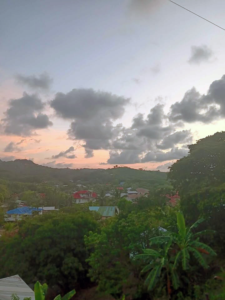
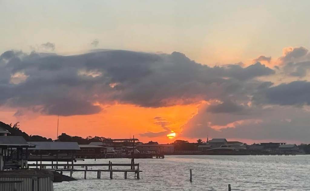
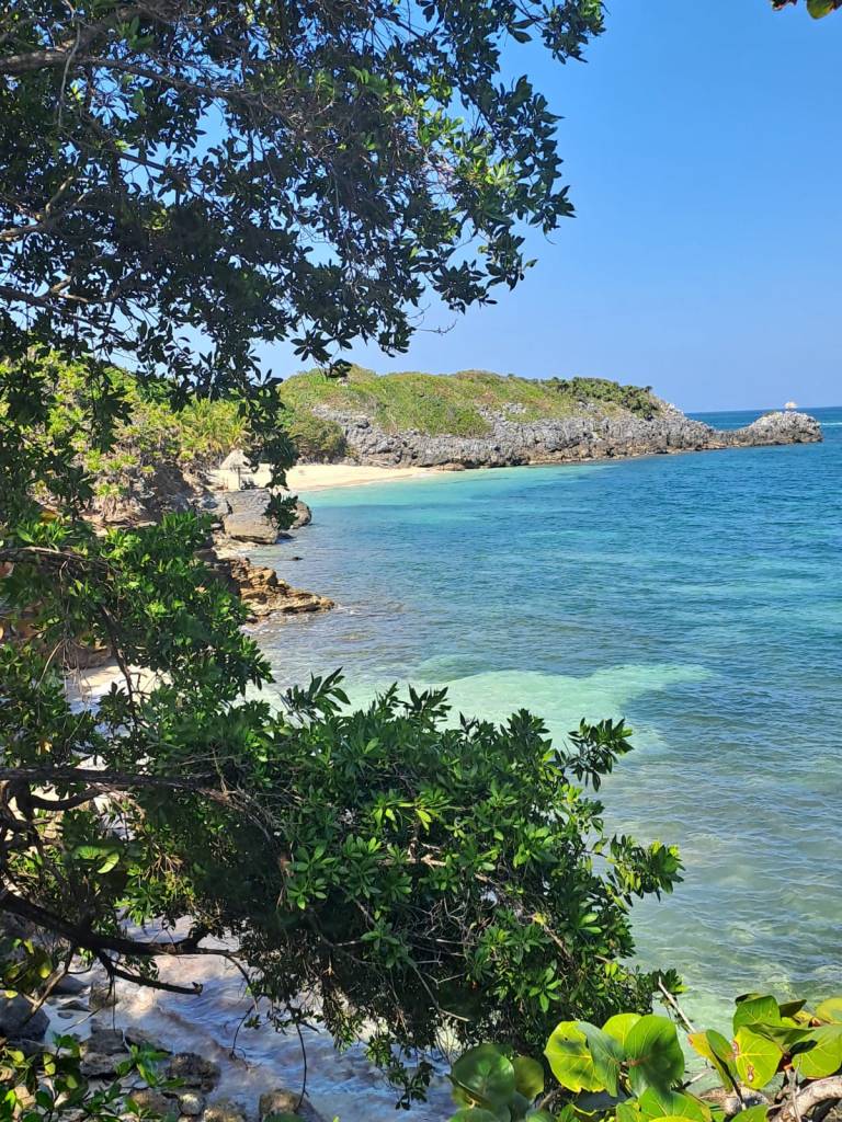
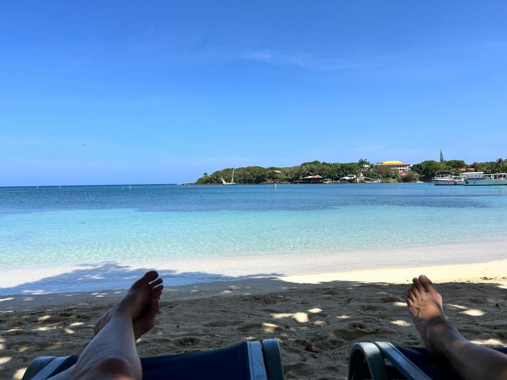
Good morning Bay Islands. I love “feet at the beach” pictures. This one comes from Kathy Jones and shows them catching a moment when the beach at West End was empty except for them one recent morning.
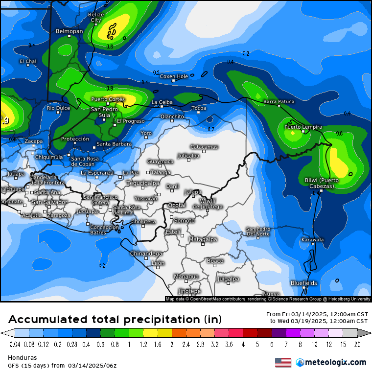
Speaking of mornings, we are hoping for a morning shower tomorrow or Thursday. It’s not a great chance, but we’ll take what we can get during dry season.

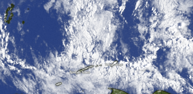
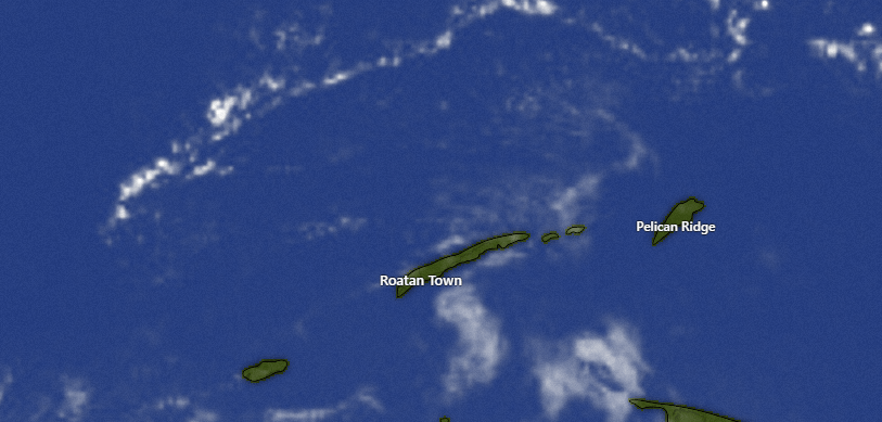
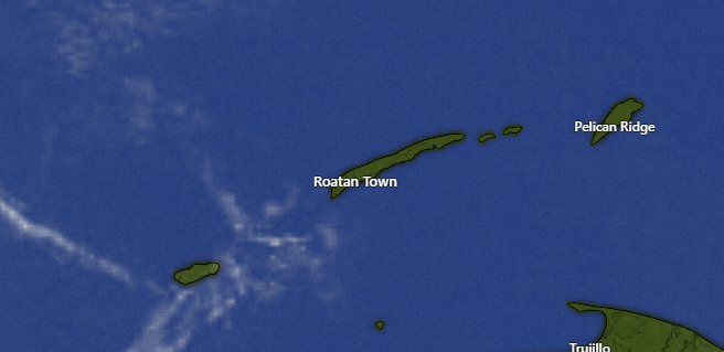
At 7:30 a.m. we have a few clouds around, especially to our northeast. These clouds are slowly moving west, but we should remain dry today. We will see a few more clouds tomorrow morning and Thursday morning and we will have about a 30 percent chance of seeing a shower each morning. After that, we will be dry again through the weekend.

Wind and Galaxy Wave forecast: We wake up to 20 mph east winds and 3 foot seas. We should calm midday to around 15 mph and 3 foot seas, and we will stay right around there through the rest of this week. This weekend looks slightly windier, with 15-20 mph daytime winds and 20-25 mph nighttime winds with seas 3-5 feet.

Many thanks to Carlos de Wit for sending along the Crown Weather Service hurricane outlook for 2025. They are forecasting a slightly above-average season due to the fact that this year will likely be neither El Nino or La Nina. They forecast most of the activity to be US East Coast, central Gulf and northeast Caribbean, which would be good news for us in the southwest Caribbean. Hurricane season starts June 1, but for us generally starts in mid to late August.

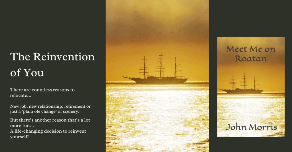
If you are an expat, this book will give you lots of familiar island experiences. If you are looking at visiting or moving here, it is a good preparation for what you will experience. John Morris’ Meet Me on Roatan. https://a.co/d/0akNNgc

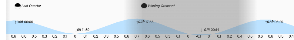
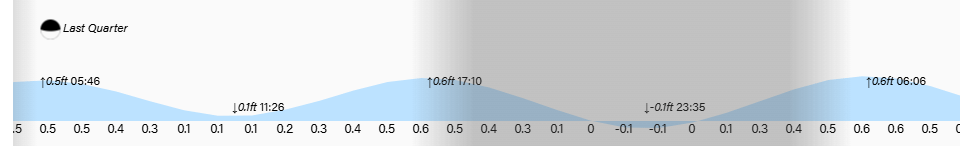
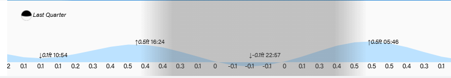
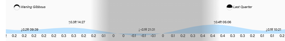
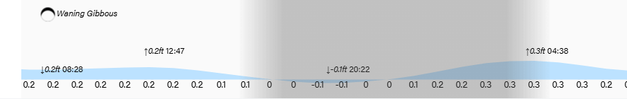
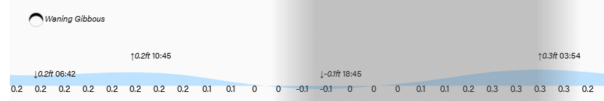
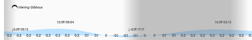
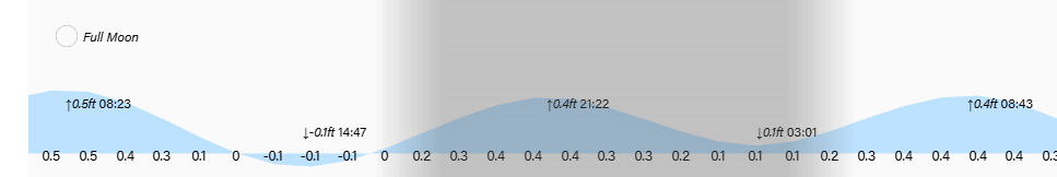
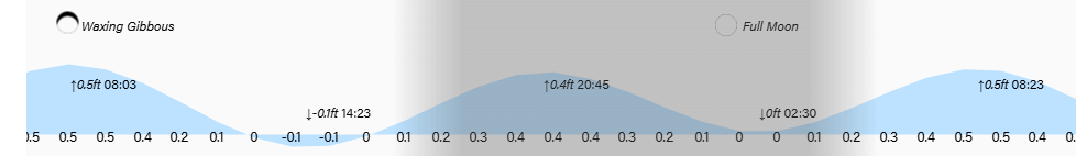
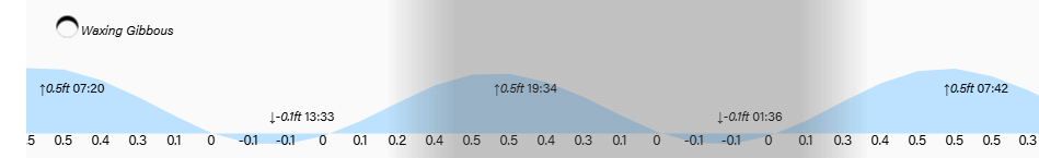
Low tides are noon and midnight. Have a great Tuesday!

March 24, 2025

Good morning Bay Islands. Our photo of the day comes from Janel Lajoie in Politilly. I love when our photos combine weather images with our lovely island communities.
The main weather feature is our wind this morning. Today will be quite windy, tomorrow very windy and Wednesday normal windy.

On satellite at 7:45 a.m. we have clear skies. We will be dry today and tomorrow. Wednesday and Thursday we have chances of morning showers, but don’t worry about a washout. This time of year we’re just talking about a 15 minute downpour then back to the beach. And that is if you get one.


Wind and Galaxy Wave forecast: We start the day with 25 mph east winds and seas around 5 feet. We should calm a bit midday to 15 mph winds, but quickly return to 25 mph winds this evening. After a windy start tomorrow we should have 15-20 mph winds and 4 foot seas tomorrow and back to a more normal 15 mph east wind with 2-3 foot seas Wednesday and Thursday.

Explore Roatan real estate with the island’s top experts at Roatan Life Real Estate. Serving clients since 2001, we offer personalized guidance in buying and selling properties. Trust our dedicated team for unparalleled local knowledge. Start your journey at http://www.roatanlife.com.

Low tides are 11:30 a.m. and 11:30 p.m. Have a great week!

March 23, 2025

Good morning Bay Islands. This gorgeous shot was taken by Chad Kemper in West End just before an early morning fishing trip.
We have a few showers around this morning, a welcome relief for some of us.

At 8:30 a.m. we have quite a few clouds around and we got some rain in places like Oakridge, Politilly and Calabash around 6:30, good from .05 of an inch, enough to get the ground wet. Guanaja has had a few waves of showers good for a tenth of an inch.
We will keep a chance of a shower around through the morning. We’ll have periods of sun this midday and afternoon, but a chance of a shower comes back at nightfall. After that we should be dry the first part of the week, but we have some moisture returning for the end of the week, especially Thursday, when it looks like we will have some scattered showers.

Wind and Galaxy Wave forecast: We wake up to east winds 15 mph and seas around 3 feet. Winds and seas will pick up speed a little during the day and by evening we will be up around 25-30 mph and seas 4-5 feet. Tomorrow we start the day windy and get a little calmer midday to 20 mph east winds and 3-4 foot seas, but by tomorrow evening we will be back to 25-30 mph and 4-5 foot seas. Tuesday we start calming to 20 mph and Wednesday through the end of the week we will have pretty consistent 15 mph trade winds and 3 foot seas.

Nothing says Sunday brunch like 2 for 1 mimosas at The Lounge Roatan, the sponsors of this month’s photo contest.

Low tides are 11 a.m. and 11 p.m. Have a great Sunday!

March 21, 2025

Good morning Bay Islands. Ashley Nolasco sent us this morning’s picture of the day, one that I like to call “Big Boat, Small Boat.”

Guanaja caught an early morning shower but the forecast is mostly dry

At 7 a.m. we have a few popcorn clouds, especially over the east side. Guanaja got .15 around 5:30 a.m. It is possible Barbarat is getting a shower and these are moving to the southwest, so it is not impossible some on the east side might see a shower, but they should move out quickly and we will be mostly sunny today and tomorrow. Sunday we will have a few more clouds and a decent chance of a morning shower, but most of Sunday should be dry.

Wind and Galaxy Wave forecast: Our winds this morning are 10 mph out of the northeast with 2 foot waves. We will stay right around there today.

Tomorrow winds will turn back to the east at 15 mph and 3 foot seas. Winds will remain around there Sunday morning, but Sunday evening through Monday we will see stronger trade winds, 20 mph during the day and 30 mph at night with seas 3-5 feet before getting a bit calmer again on Tuesday.

There are few tournaments more exciting than the NCAA basketball tournament, known in the States as March Madness. And there isn’t a better way to celebrate than to get grilled meats and chorizos from the preeminent meat market on Roatan, Rosita’s in Coxen Hole and French Harbour.


Tides continue to be mild. Have a great Friday!

March 20, 2025

Good morning Bay Islands. Our photo of the day is a Utila sunrise from Tracy Norris.

The main change in our weather is that we are looking for stronger trade winds come Sunday and Monday.

We have a few high clouds and no rain around the islands this morning. Our forecast is dry except for a slight chance of a morning shower on Sunday morning.
Wind and Galaxy Wave forecast: East winds are 15 mph and seas 2 feet. Those conditions will continue through Saturday. Sunday and Monday winds will pick up to 20 mph during the day and 25-30 mph at night with seas around 5 feet.

With the seas fairly calm through Saturday, it will be a great time to do some exploring.

Tides will remain low. Have a great Thursday!

March 19, 2025

Good morning Bay Islands. Our photo of the day comes from James Thomas and shows a tranquil day at Anthony’s Key.
Many of us got a good rain yesterday evening around 6 p.m., good for half an inch in some locations. This morning, Utila has gotten some showers ranging from half an inch to an inch.

This morning at 7 a.m. we have lingering clouds, especially over Utila. We will keep a chance of a morning shower around, especially for the west side and Utila, but as the day goes on we will clear out and get dry. We should be dry until at least Sunday, when a small wave of moisture comes across the islands.

Wind and Galaxy Wave forecast: Winds are out of the east this morning around 12 mph and seas 4 feet southside. Winds and seas will calm a little toward midday to two feet, but winds will get up to 20 mph and seas 4 feet overnight. Thursday and Friday should be a bit calmer with east winds 10 mph and seas 2 feet. Saturday and especially Sunday and Monday winds get stronger, 20 mph during the day and 25-30 mph at night with seas 4-6 feet south side.

Our weak cold front knocked our temperatures back a little. We had a high of 84F (29C) yesterday. We will start a warming trend that will put us back into the upper 80s (31C). That is perfect for jumping in the water with a group of fellow travelers with Jolly Roger Roatan.

Tides remain low. Have a great Wednesday!

March 18, 2025

Good morning Bay Islands. No photo of the day today, just condolences to the families of those lost in the tragic crash. Most of our readers have probably flown out of Roatan Airport, including on short flights to the mainland, so this hits home. John 5:28,29.

Most of the rain overnight occurred around 2 a.m. and fell mostly on the east side. Looks like Calabash was the big winner. There are two stations in Calabash Bight. One got just over an inch and the other got almost 2 inches. Around 7:30 a.m. Guanaja picked up another shower to get up to two-thirds of an inch.

We have a lot of clouds around the islands at 7:30 a.m., but we don’t see a lot of rain out there this morning. The heaviest clouds are over Guanaja and to the south of Roatan. These clouds are moving to the southwest. We will keep mostly cloudy skies through today and a chance of a shower here or there. The computers think tomorrow will be dry, but I think there might be an early morning shower, but most of tomorrow should be sunny. Thursday morning we get a small chance of a morning shower, but also a mostly sunny day. Into the weekend will be dry.

Wind and Galaxy Wave forecast: We start the day with northeast winds around 15 mph and seas 5 feet north side. We will stay right around there today. Tomorrow east winds return, 15 mph and 2-3 foot seas during the day and 20 mph and 3-4 foot seas nighttime. We will stay right around there until the weekend, when east winds pick up to 20 mph during the day and 22-27 mph at night.

Tides continue to be mild. Have a great Tuesday!

March 14, 2025

Good morning Bay Islands. Our photo of the day comes from Larry Cox, who captures the blood red moon during full eclipse last night from West Bay. We had a great view of the eclipse here, with very few clouds. We should be mostly sunny through the weekend, with a few more clouds Monday and especially Tuesday with a chance of showers.

We have a few high clouds this morning, but we will remain mostly sunny through the weekend. Monday we will see some clouds moving in from a VERY weak cold front.

Here is the GFS forecast of rain through Tuesday. It looks much less impressive than the forecast we had a week ago for the cold front that brought many of us half an inch to an inch of rain. This system may leave some of us dry and give others of us a shower or two. I would say the best chance of rain right now looks to be Tuesday evening. After that we go back to being dry. This is March after all.

Wind and Galaxy Wave forecast: This morning we have southeast winds 5-10 mph and seas around 2 feet. We will stay fairly calm through the day today, but this evening and overnight east winds will pick up to 15-20 mph and seas 3 feet. Tomorrow we will have daytime winds from the east around 15 mph and 3 foot seas and over night 20-25 mph with 4 foot seas. Sunday looks like a calmer day and Monday and Tuesday the winds turn to the north, mostly around 10 mph, but Monday evening through Tuesday morning north winds will be around 15 mph and seas 2-3 feet northside. After Tuesday winds turn back to the east and will be moderate 10-15 mph.

Weekends are made for grilling, and you will want to get the best meats on the island by heading over to Carniceria Rosita in French Harbour or Coxen Hole.

Low tides are 3 p.m. and 3 a.m. Have a great Friday!

March 13, 2025

Good morning Bay Islands. Our photo of the day comes from Marcella Husband who took this fantastic shot of the moon during last month’s full moon. Not only will the moon be full tonight, we will have a full lunar eclipse. Totality will begin for us around 12:30 a.m. and it will last until around 1:30 a.m. It will be our only total eclipse until 2029. There may be a few clouds around, but we should get a good look at the moon, which will turn blood red.

At 7:30 a.m. there are a few high clouds around Utila, but no rain. We will be dry the rest of this week and weekend. There is a chance of rain with a small norther coming in Monday evening into Tuesday.

Wind and Galaxy Wave forecast: We have light winds this morning around 5 mph from the southeast and seas around 2 feet. Winds will be fairly light and seas will stay around 2 feet today and tomorrow. Tomorrow evening east winds will gust to 20 mph and seas to 3 feet. Saturday looks like the windiest day of the next week, with east winds 15 mph during the day and 20-25 mph at night and seas 3-4 feet. Winds get calmer Sunday and start to turn to the north Monday and Tuesday 10-15 mph and seas 2-3 feet northside.

Our weather is perfect weather for taking man’s (and woman’s) best friend to the beach. If your dog’s coat is not as bright and shiny as it should be, perhaps it is improper nutrition, a result of corporate pet food. Reward your good boy with specially crafted, locally sourced food from Mitch Cummins Roatan Pets food and watch that coat get healthier day by day.

Low tide is 2:30 p.m. and 2:30 a.m. Have a great Thursday!

March 11, 2025

Good morning Bay Islands. Our photo of the day comes from Davinci McNab at Paya Bay Resort. This was taken on a clear day but today we have plenty of clouds and some rain around.

On satellite at 8 a.m. we can see the cold front over us. Individual rain clouds are moving from north to south. We also have a few breaks in the clouds. At 8 a.m. West Bay has gotten almost an inch of rain, while Sandy Bay has received between a quarter and half an inch and points east have gotten little or no rain. Rain should decrease as the day goes along, but we will keep chances of a few scattered showers around all day.
We will have a small chance of rain tomorrow morning, but after that we should stay dry and sunny the rest of the week into the weekend. We are watching another system that could bring rain next Monday into Tuesday.

Low tides are 1:30 p.m. and 1:30 a.m. Have a great Tuesday!