Dec. 6, 2021: Good morning, Roatan! This morning some low clouds brought very light showers to some of us. We got rain here on Lucy Point but not enough to register even .01 of an inch. Those clouds should clear out and we should have a nice day. Today will be the last day for relatively calm winds from the east/southeast at 5-10 mph. There will be a small chance of a shower overnight.Tomorrow the trade winds return with east winds 15-20 and seas at 3 feet (1 meter). Days will be mostly sunny and there will be small chances of overnight showers, but mostly a dry forecast for the week ahead. Have a great week!
Dec. 5, 2021
Dec. 5, 2021: Good morning Roatan! Most of us caught a shower yesterday evening, getting between a tenth and a quarter of an inch of rain and some of us saw a shower this morning for a smaller amount. Here on Lucy Point we got almost half and inch yesterday and .17 of an inch this morning.
There are still scattered showers around on radar so we will keep a chance of a shower around through the morning, but this afternoon should be nice, with light winds 4-7 mph out of the north and seas at 2 feet (.6 meters). There will be a small chance of a shower overnight, then partly cloudy to mostly sunny skies on Monday with east winds at 5-10 mph. The trade winds return in force on Tuesday at 15-20 mph and seas at 3 feet (1 meter) and should stay that way for the rest of the week. Rain chances for the week ahead will be small and mostly at night. Have a great Sunday!
Dec. 4, 2021
Dec. 4, 2021: Good morning, Roatan! One of the big questions for today’s weather is whether the rain approaching Guanaja will make it all the way to Roatan. Most of the models show it weakening as it approaches the island. I would say the east side of the island has a better chance of rain (maybe 70 percent) than the west side (about 40 percent). Aside from the chance of rain today, we will have east/northeast winds at 12-17 mph and seas at 3 feet (1 meter).After a good chance of rain tonight, tomorrow and Monday look like very nice days, with light and variable winds and seas at 2 feet (.6 meters)Starting Tuesday, the trade winds start blowing at 15-20 mph giving us 3 foot (1 meter) seas and dry conditions for the rest of the week into next weekend. Have a great weekend!
Dec. 3, 2021
Dec. 3, 2021: Good morning, Roatan! Rain was widespread across the island yesterday, with most of us picking up over an inch in the 24 hours ending 7 a.m. this morning (Jimmy Andrade in Camp Bay reported no rain, but that was definitely the exception.)
Today we have scattered clouds and a chance of a shower, but we shouldn’t get as wet as we did yesterday. Winds will be east/northeast at 7-12 mph and seas at 2-3 feet (.6 to 1 meter). Rain chances are high tonight, tomorrow and tomorrow night. Sunday looks very nice. Monday evening and Tuesday morning there will be about a 30 percent chance of seeing a shower, but our easterly trade winds start back, especially Tuesday in the 15-20 mph range. Wednesday through the weekend rain chances will be very low. Have a great Friday!
Dec. 2, 2021
Dec. 2, 2021: Good morning, Roatan! I woke up to a slow, steady rain this morning coming from some low clouds. It looks like the wave of moisture is coming a little earlier than expected.
Today we will have partly to mostly cloudy skies and a chance of rain through the day. Winds will be from the north/northwest at 5-10 mph this evening. Rain chances will last into tomorrow morning. We should get some clearing and a low chance of rain in the middle of the day tomorrow, but rain chances return overnight Friday, through the day Saturday and into Sunday morning. After that things should clear out. The first of next week our rain chances will be small and mostly at night and our easterly winds at 15-20 mph should return Tuesday. It will be our first taste of TRW (Typical Roatan Weather) in a month and a half. Have a great Thursday!
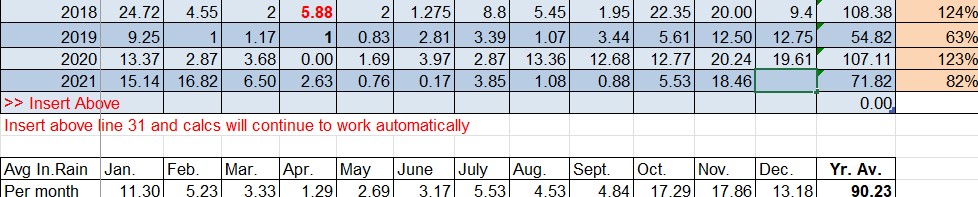
November 2021 rainfall
We ended November with 18.46 inches of rain for November, which is only slightly above average for what is usually our rainiest month of the year. Unless we get 19 inches in December (which kind of seems unlikely given our forecast for the next week) we will end the year below normal for rain. Based on averages, we are past the peak for the rainy season. December and January are, on average, fairly rainy at 13 and 11 inches on average before we get back to drier weather in February.
Dec. 1, 2021
December 1, 2021: Good morning, Roatan! A few locations got a little rain overnight. West Bay picked up .15 of an inch and Coral View got .06. Here on Lucy Point we got down to 70 degrees this morning along with a few other locations on the island. We’ve been having wonderfully cool nights, great sleeping weather.
Get ready for a beautiful day with calm winds and seas maybe getting up to 2 feet (.6 meters). Tomorrow will also be nice, but chances of rain will increase toward evening and we will have scattered showers Friday into the weekend. Right now those showers don’t look as numerous as we have had with previous systems and this isn’t a cold front, just a wave of moisture. We’re actually looking for a slow return to our dominant east winds starting next week for the first time in awhile. Have a great Wednesday!
Nov. 30, 2021
Nov. 30, 2021: Good morning, Roatan! West Bay picked up quite a bit of rain (.65 of an inch) in evening squalls yesterday, while West End got .05 yesterday evening. Sandy Bay got some light showers in the early afternoon hours, but mid-island and east Roatan was dry after the morning hours.
Conditions look nice to end November and start December. We’ll have partly cloudy skies with only a slight chance of a pop up shower through Thursday. Winds will be mostly from the west at 3-7 mph and seas at 1 foot (.3 meter). Rain chances will go up Friday and Saturday. Have a great Tuesday!
Nov. 29, 2021
Nov. 29, 2021: Everybody got wet overnight. Mid-island and Camp Bay got under half an inch, but we got .86 of an inch on Lucy Point and West Bay got 1.2 inches.
We’ll keep some scattered morning showers around, but things should clear out this afternoon. This afternoon through Thursday looks pretty nice, with partly cloudy to mostly sunny skies, light winds and low seas mostly around 1 foot (.3 meters). Friday and Saturday a good chance of rain returns, but there are no cold fronts in the forecast for at least the next week and a half, so we should start warming up.
Nov. 28, 2021
Nov. 28, 2021: Good morning, Roatan! We got down to 69 (20.5 C) degrees here on Lucy Point this morning. Brrr cold! With no cold fronts expected this week, I think we should get a little warming trend, with lows only getting into the mid 70s (24 C) by midweek and highs in the mid to upper 80s (around 30 C). Today will be mostly sunny with only a very minimal chance of a shower until tonight. Winds will be light and variable and seas around 1 foot (.3 meters). Overnight and tomorrow morning we have a 40 percent chance of showers with northwest winds 7-12 mph. Tuesday through Thursday look like nice days with fairly calm winds. There is some disagreement in the models about whether Friday and Saturday might have a higher chance of rain. We’ll have to wait and see. Have a great Sunday!
