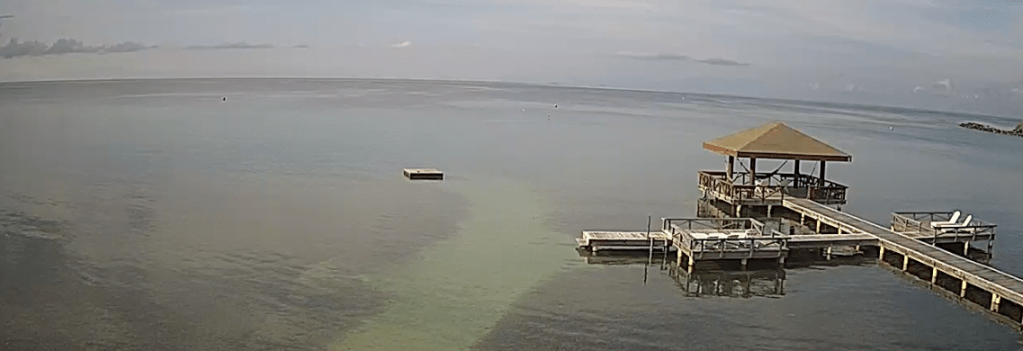
Good morning Bay Islands. Our photo of the day is a screenshot from the webcam of CoCoView near French Key. You can see our flat calm waters. Flat seas and calm winds will continue into the first part of the week, and the end of the week only looks slightly windy. All in all we have a great week ahead.
On satellite we can see a few clouds that might have a shower in them. All of this is slowly moving south. I think most of us will stay dry. The forecast into the first part of the week is mostly dry, with only a small chance of a quick morning shower.
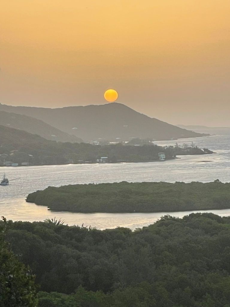
Good morning Bay Islands. Our photo of the day comes from Jeffrey Hill, who notes that God perfectly balanced the sun on top of Calabash Hill overlooking Oakridge/Pandy Town. We have some storms to the east of us, but we should be dry today. Perhaps a slightly better chance of showers tonight.
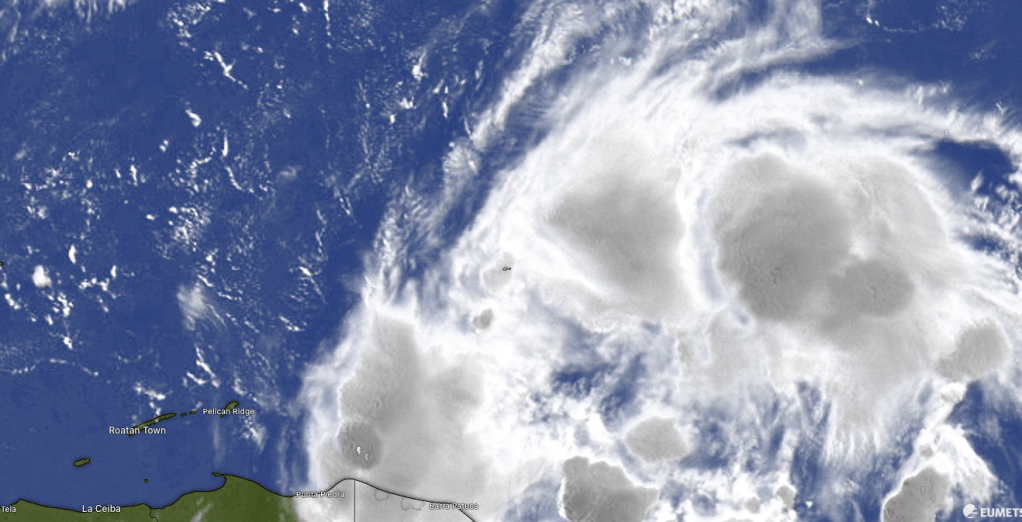
You can see on satellite at 8 a.m. there are quite a number of storms over toward Swan Island, but we just have some high clouds. Those storms should disappear as the morning goes on, leaving us with mostly sunny skies. Tonight the Euro really wants to give us a few showers, so we will increase the chance overnight and early tomorrow morning to 40 percent, but for the most part, the weekend should be dry. We will continue mostly dry into next week.
Wind and Galaxy Wave forecast: We wake up to 12 mph east winds and seas 2 feet. Today is the day we start seeing conditions really calm, with a weekend of almost flat calm conditions. On the downside, that means it’s going to be hot, with mostly sunny skies and not much wind. The temperature will only be around 90 (32C), but it will definitely feel hotter.
Good news from Roatan Operation Animal Rescue. A brigade of doctors is coming down to do a spay and neuter clinic on the East End and they are raising money to cover costs (about $25 per animal, a great deal). One way to assist in that effort is to buy Roatan Pets food from Mitch Cummins for your furry friend. Ten percent of proceeds goes to the great work of ROAR.
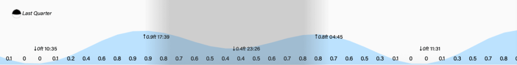
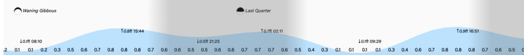
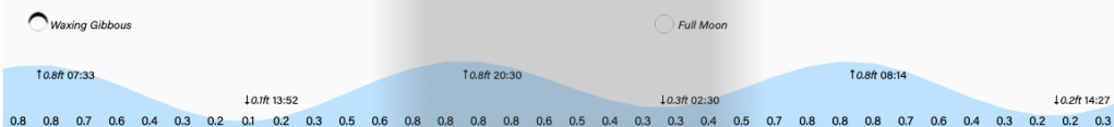
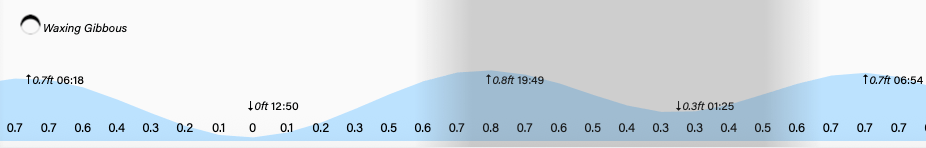
Lowest tide is right about now (8:10 a.m.) but it really isn’t all that low. Have a great Friday!
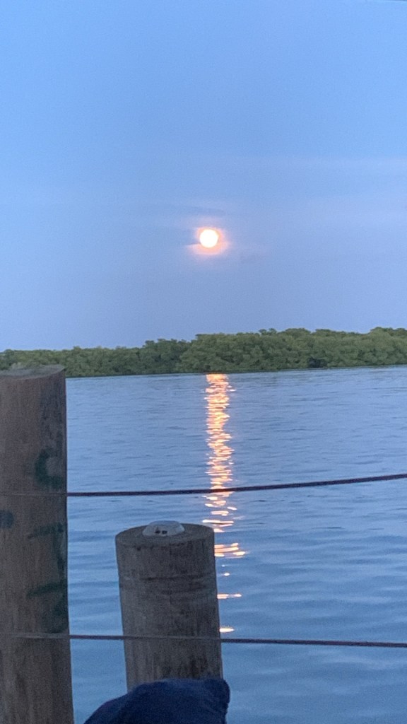
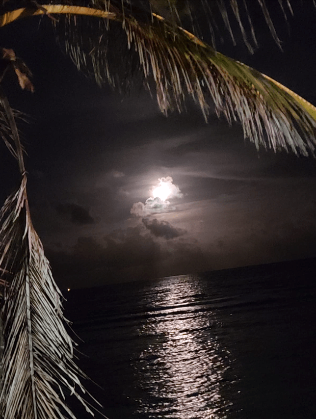
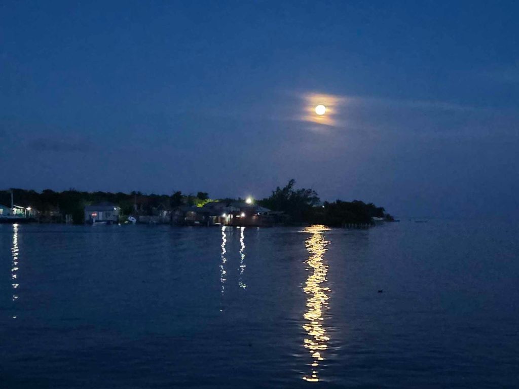
Good morning Bay Islands. Our photo of the day is this moon shot from Michael Fulford, taken from his boat docked at Trico in Jonesville Point/Czech Village. The rain missed most of us (except for Guanaja) yesterday. Will it miss us today?
This is our overnight satellite and you can see the counterclockwise rotation of a low pressure system moving to our north toward Belize. This morning we again have some storms to our east. These should at least bring some midmorning clouds and perhaps a shower here or there, but I wouldn’t hold my breath. Our forecast continues to have low chances of overnight or morning showers, about 20 percent each day.
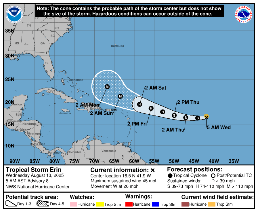
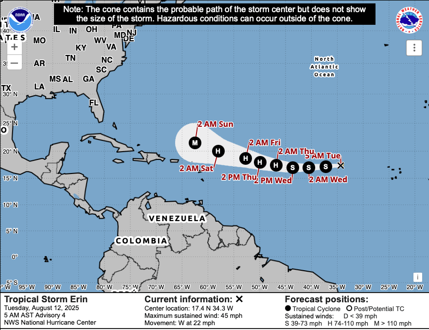
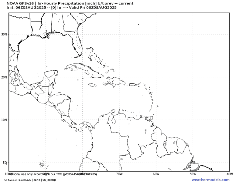
Tropical Storm Erin is forecast to become our first Atlantic hurricane of the season (MidAugust, can you believe it?). But it continues to move far from us, completely outside of the Caribbean. There is nothing in the extended forecast that makes us worried about the next two weeks around here.
Wind and Galaxy Wave forecast: We wake up to east winds 15 mph and seas 3 feet. They should calm during the day to 10 mph and 2 feet. We will continue with similar winds through Friday. This weekend into the first part of next week we are looking at close to dead calm conditions, perfect for being on the sea.
With great weekend weather in the forecast get ready with the best in steaks and pork chops at Carniceria Rosita in French Harbour and Coxen Hole!
Tides continue to be relatively high. Have a great Wednesday!
Good morning Bay Islands. Our photo of the day comes from Katy Pandy with some heart-shaped clouds covering the full moon over Gravel Bay a couple of nights ago. This morning we have some storms off to our east and chances of rain this evening.
This morning’s satellite shows the storms in what I like to call our rain factory over near the Mosquito Coast. These will move our way this afternoon meaning an increasing chance of rain as we get to nightfall, but there is some indication most of these storms will move to our north, so there isn’t a guarantee of rain. I’ll call it 50/50 through tomorrow morning. After that, we go back to low 20 percent chances of rain, mostly overnights and mornings, into the weekend.
Wind and Galaxy Wave forecast: We will have 15 mph daytime winds with 2-3 foot seas and 20 mph nighttime winds with 3-4 foot seas through this week. This weekend winds get quite calm.
Out in the eastern Atlantic we have Tropical Storm Erin (that’s right, it’s almost mid-August and we are only up to “E”, the fifth named storm). As you can see in the map it is forecast to stay east and north of the Caribbean, probably not even threatening the US as it turns back to sea. Our tropical forecast remains very calm.
Explore Roatan real estate with the island’s top experts at Roatan Life Real Estate. Serving clients since 2001, we offer personalized guidance in buying and selling properties. Trust our dedicated team for unparalleled local knowledge. Start your journey at www.roatanlife.com
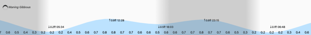
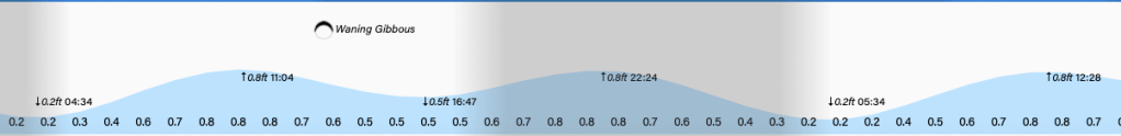
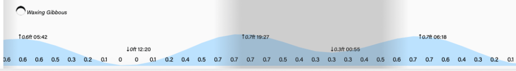
Tides remain higher than average as our moon begins to wane. Have a great Tuesday!
Good morning Bay Islands. Our photo of the day comes from Troy Standish and shows our full moon over Fiddler’s Bight near Calabash. The most is reflecting in the calm waters. We will be calm much of today, but we pick up our trade winds tonight into tomorrow.
Our satellite shows clear skies this morning. We should be mostly dry through Monday, with a small chance of isolated showers, mostly overnights and mornings. Tuesday evening into Wednesday morning it still looks like a small tropical wave will pass over that should give us better chances of more substantial rain.
Wind and Galaxy Wave forecast: We wake up with calm winds and seas. Winds will pick up this evening to 15 mph and seas to 2 feet. Starting tomorrow we will be back to more typical trade winds, with east winds 15 mph and seas 2 feet daytimes and 20 mph and 3 feet nights.
Through tomorrow you can get a special deal of 1000 lempira round trip to Le Ceiba when you buy your Roatan Ferry Galaxy Wave tickets at Petrosun!
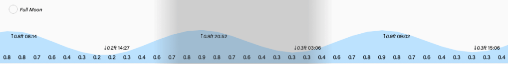
Tides will run on the high side as we continue with our full moon. Have a great weekend!
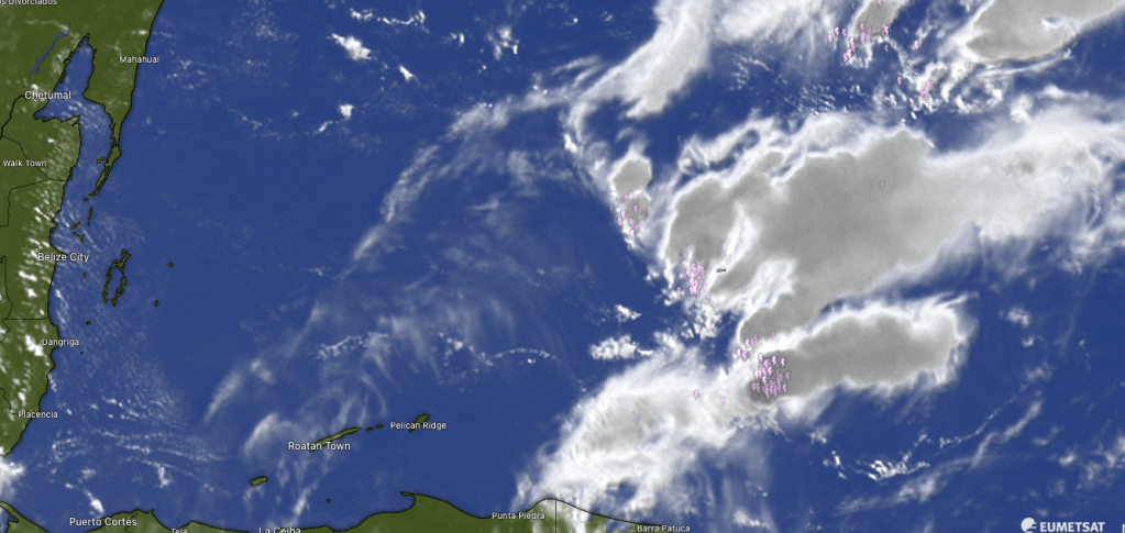
Good morning Bay Islands. Last night Guanaja got a shower around 1 a.m. good for .08 of an inch. East end and midisland got some rain around 2 a.m. with most locations getting under a quarter of an inch. This morning’s satellite shows a few popcorn clouds out there. We will continue to have small chances of short-lived showers today and through the weekend.
This is the time of year we look to the Caribbean for any tropical development. The GFS model is predicting a tropical wave coming over us middle of next week, but right now it isn’t showing any rotation on this storm. We will keep an eye on it.
Wind and Galaxy Wave forecast: Winds are around 5 mph and we are in for a great couple of day on the sea, with mild east winds around 5 mph and seas maybe 1 foot. Starting Sunday we get back to more normal east winds 15 mph days and 20 mph nights with 3 foot seas.
There’s nothing better for the weekend cookout that a tender cut of meat sliced up by the butchers at Carniceria Rosita.
Low tide is around 2 a.m. as we move into full moon.
Good morning Bay Islands. Our photo of the day comes from Elena Gonzalez-Maldonado, taken near Buccaneer in French Harbour. When people ask me the best time to visit Roatan, I often tell them August and September, especially if they are interested in boating, fishing, diving and snorkeling. The primary reason is the winds tend to be calmer. We will really see those calm winds and seas tomorrow through Saturday.
There is hardly a cloud in the sky this morning and dry conditions will be common through this week. We wake up to 17 mph east winds and seas 4 feet. We should calm a bit to 3 feet through the afternoon, but the big change will be tomorrow through Saturday, when we are expecting east winds 5-10 mph and seas 1-2 feet. There should be times, especially on Friday, when winds are almost still and the sea is flat calm. Sunday into next week, we will be back to 15 mph east winds and seas 2-3 feet.
Speaking of being in the sea, there is nothing more gorgeous that a healthy canine coat swimming in Roatan’s crystal clear waters. To keep your pet’s coat nice and healthy contact Mitch Cummins at Roatan Pets and order specially formulated, locally sourced pet food that keeps your good boy healthy and ready for a splash in the sea.
Our photo of the day comes from Bena Fremaux, whose family is vacationing on the island. They send their love to the Bay Islands from West End. Many of us got a shower overnight but we are looking for drier weather ahead.
Here is the satellite for 1 a.m. to 7 a.m. You can see storms move across the island. between 2 and 3 a.m. give most of us between a quarter and half an inch of rain. We are still dealing with morning clouds and perhaps a shower here or there, but as we get into the afternoon we will have drier weather and clearer skies.
The reason why we will be having drier weather going forward is shown in this water vapor forecast map, that shows us getting drier yellows and greens for about the next week. That means perhaps a 10-20 percent chance of a shower mornings and overnights and mostly clear skies. We see some moisture return middle of the month. This forecast also shows a tropical system moving through the northern Caribbean. This system does not exist yet and most models show it, if it happens, moving much further north. But we’ll keep an eye on it.
Wind and Galaxy Wave forecast: We wake up to east winds 15 mph and seas 2-3 feet. We should get windier this afternoon into the evening, getting up to 25 mph and 4 foot seas. Tomorrow we will be back to 15 mph east winds and 3 foot seas. Thursday through Saturday we’re looking at quite calm conditions, with east winds 5-10 mph and seas 1-2 feet. That, along with dry weather, should make the end of this week into the weekend the perfect time to get out on the sea.
The perfect folks to get you out into the sea are at Jolly Roger Roatan. Don’t forget that they are available for booking, especially on non-cruise days, for your special events.
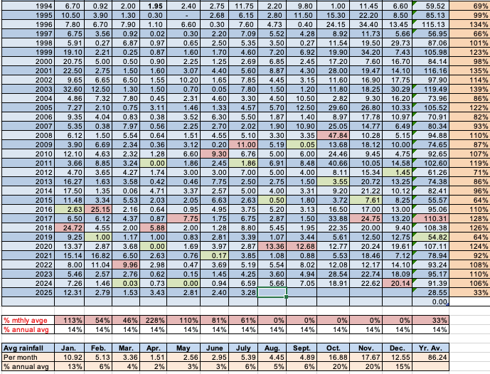
July was a month where the east side got a lot more rain than the west side of Roatan or Utila. We’re going with Sandy Bay’s 3.28 inches for consistency, because consistency demands we use the rainfall for the same area, instead of picking and choosing which total to use. The west side’s rain amounts (or Utila’s amount of under 2 inches) was well below the monthly average of 5.39 inches. Whereas the east side, particularly around Oakridge and Politilly, got 6-8 inches. This is not uncommon this time of year, when our weather comes from the rain factory off the Mosquito Coast, as opposed to rainy season, when the rain builds in from the mainland.
Looking ahead, August averages 4.45 inches, but it is also the month when we really start paying attention to the possibility of tropical storms. So far, the Atlantic has been extremely quiet. Let’s hope it stays that way. As for our extended forecast, we see waves of tropical moisture coming in, so occasional downpours, especially overnights and early mornings, will continue.
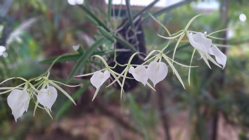
Good morning Bay Islands. Our photo of the day is from Helen Murphy and shows orchid 𝘣𝘳𝘢𝘴𝘴𝘢𝘷𝘰𝘭𝘢 𝘯𝘰𝘥𝘰𝘴𝘢, Lady of the Night”, called such because of the jasmine like scent it exudes only after dark. It grows wild on Roatan and like all orchids it loves damp conditions. We’ve had plenty of those, but this morning we’re looking a little drier. More in comments.
On satellite at 7 a.m. we see some popcorn storms moving away from us to our north and blue skies overhead. There will be a low chance of a popup shower today, but most of us should be dry. As we move through the end of the week, we will continue to have chances of shower, mostly overnights and mornings.
Wind and Galaxy Wave forecast: We wake up, still pretty calm with 7 mph east winds and 2 foot seas. We should get a little windier today, 15 mph this afternoon and 20 mph tonight from the east. Winds 15-20 mph will continue Thursday and Friday, but the weekend looks calmer.
Don’t forget the special Roatan Ferry Galaxy Wave schedule to the Guanaja Conch Festival. This weekend looks like a great time to be on the water.