We’re kind of late with our September 2025 rainfall total, but we’re going with 2.42 inches from Sandy Bay, but that amount is pretty typical acrosst he islands, except for Utila, which got over 4 inches. We only got about half the rain for a normal September.
Looking ahead, October is the first month of the rainy season, though the really rainy part usually start in the second half of the month. Most locations have already received around 2 inches for the month and there are good rain chances ahead in our forecast, thought still no signs of any tropical storms.
Good morning Bay Islands. Our photo of the day is a full moon over Fiddlers Bight from Winnie Standish. With very few clouds last night it was a good night to get a glimpse of the full moon, referred to in North America as the Harvest Moon. We have one day with a bit of wind before we get real calm again.
On satellite as we near 7 a.m., we see a good-sized storm in southern Belize, but that won’t bother us. We have mostly clear skies and will have a very low chance of rain today. Tonight into tomorrow morning we will have a 30 percent chance of an overnight or early morning shower.
Wind and Galaxy Wave forecast: We wake up to 18 mph east winds and seas around 3 feet. We should stay right around 15 mph east winds and 2-3 foot seas today, but tomorrow into the weekend we will get quite calm with periods of dead calm.
I’ve always said this is the best time of year to visit the island, with calm winds and seas and great weather. Look up Jolly Roger Roatan for the best excursions, whether you’re visiting via airplane or booking from a cruise.
Good morning Bay Islands. This beauty of a crab was captured near CoCoView by Michele Southerland. If you find yourself wanting a glimpse of the islands in real time, CoCoView has a great live cam. Weather continues to be great with most of us staying dry and fairly calm. We will have scattered showers and a little nightime wind this week.
The satellite view between 6:30 and 7:30 a.m. shows a few popcorn clouds over West Bay and Utila. There may be a shower or two in there, but there is a big storm off the Mosquito Coast, but like most of these storms, it will weaken as the day goes on. We will continue to have partly cloudy skies and scattered showers, mostly overnights and early mornings. This time of year it is very difficult to predict exactly where rain will fall because it is so random, but it is out there, and when you get it, you will get a quick downpour and then it will be over.
Wind and Galaxy Wave forecast: We wake up to very mild southerly winds and seas around 1 foot. We will stay mostly calm during daytimes, but at nights we will see east winds kick up to 10-15 mph and seas around 2 feet. Have a great Sunday!
Good morning Bay Islands. Our photo of the day comes from Traci Kaltenbacher who has found a unique way to frame a sunset with sandia (watermelon). There are indications of an increase in rain Sunday evening into early next week.
On the satellite from 7-8 a.m. we cann see partly cloudy skies over us, but we also see rain forming in the area of Mosquitia that I call our rain factory. We will have lower rain chances today and most of tomorrow (maybe 40 percent) but most models say that a low pressure system will move just to our north Sunday evening into early next week that will push our rain chances up to 60-70 percent daily.
Wind and Galaxy Wave forecast: This morning we are a bit windier and wavier than we have been, with 10 mph east winds and seas about 2 feet. That should calm midday to 5-10 mph and 1 foot. Tomorrow will be about the same, but as we get into Sunday evening into early next week, we may see winds increase a bit, perhaps 15 mph and seas 2-3 feet. If the low pressure forms as expected, we may be seeing some westerly winds by Tuesday or Wednesday.
If you are visiting for Semana Morizanica, head over to Carniceria Rosita if your rental has a grill, to find the freshest meats on the island in Coxen Hole and French Harbour.
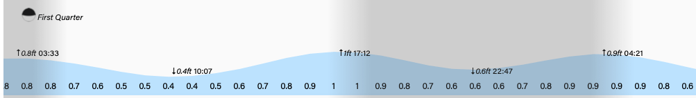
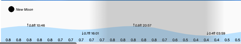
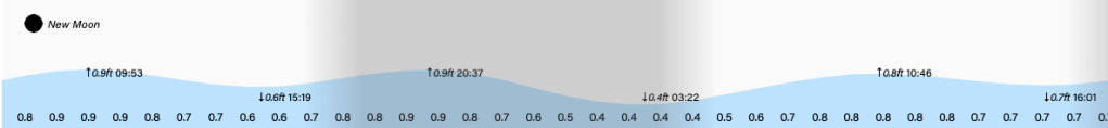
Tides remain on the high side. Have a great Friday!
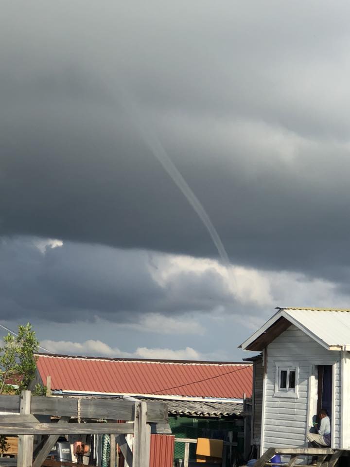
Good morning Bay Islands and welcome to October. Our photo of the day comes from John Norburn who captured this waterspout near the Utila Cays. You may also have seen a video that was passed around from West Bay of a waterspout. Ironically West Bay recorded no actual rain, while mid-island and east end got up to 2.5 inches. We will see continued rain chances and calm seas.
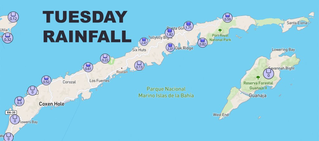
Here is the rainfall for yesterday. You will notice mid-island got a lot of rain in about a 1 hour period. The atmosphere we’re currently dealing with can produce a storm at any time, but most of the time we will be partly cloudy. Our winds and seas continue to be quite calm, so most of the time our weather is picture perfect, we just need to deal with occasional showers.
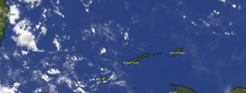
Our satellite at 7:45 a.m. shows mostly clear skies over us and a few popcorn clouds to our west. These clouds aren’t moving much, since there isn’t a lot of wind, even up in the atmosphere. That means if you get a rainstorm, it doesn’t move away quickly and you can easily pick up 1-2 inches before it rains itself out.
Tides continue to run high. Have a great Wednesday!
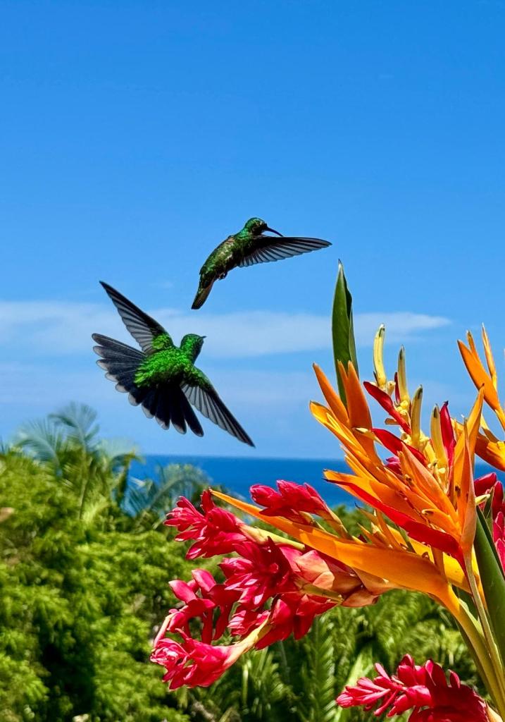
Good morning Bay Islands. I am a sucker for hummingbirds. I consider them among God’s most amazing creations. Andrea DeMille captured these with one of man’s most amazing creations — the iPhone from her porch in Palmetto Bay. This is the last day of this month’s contest, but the new contest starts tomorrow, sponsored by Jolly Roger Roatan. Send photos with name and location to bookmybio@gmail.com.
Tomorrow starts the main portion of Semana Morazánica and we will have some lovely weather. There will be a chance of rain here and there and maybe slightly more wind on Thursday but all in all it will be great.
On satellite at 7:30 a.m. we don’t see anything that looks like much rain at all. We will continue to have small rain chances, mostly overnights and early mornings, but any rain should be short lived and pass on by.
Wind and Galaxy Wave forecast: We continue to have calm winds and flat calm seas. There is a period from Wednesday evening through the day on Thursday when we should have a breeze, perhaps 7-12 mph from the east, but our seas should only be around 2 feet at their waviest, and then we go back to flat calm for the weekend, so almost the perfect setup for the holiday week.
If you are visiting the islands from the mainland, check out Roatan Pets and perhaps take back with you some of the most nutritious, scientifically formulated food for your furry friend.
Check out the special Semana Morazánica schedule from Roatan Ferry Galaxy Wave with smooth rides all week.
Good morning Bay Islands. Our photo of the day comes from Melissa Fleming. It was taken last week from Bananarama, but could have easily been taken yesterday. We had a popup shower that brought about an inch of rain midisland. That storm was not with a tropical system, but was caused by differential heating between the island and the sea. These pop up from time to time and are very hard to predict. So, let’s try to predict the weather!
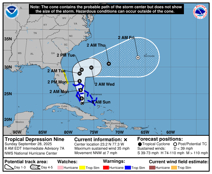
A quick tropical update. The tropical depression should become Tropical Storm Imelda and affect the western Bahamas, including Freeport and Nassau. After exiting the Bahamas it will likely become a low-level hurricane, but should turn out to sea before striking the U.S. coast. Still nothing for us to worry about in the Caribbean.
At 8:50 a.m. we have some showers over Barbarat and Morat the are weakening. We also have some showers north of Utila that are moving to the west and will likely miss the island entirely. We will continue to have very low rain chances, mostly at night and early morning and we will continue to have quite calm winds and seas. Enjoy!
Good morning Bay Islands. Our photo of the day comes from Lou Marnell and was taken from the marina at Parrot Tree midisland. Remember the winner of our monthly photo contest gets an excursion valued at $100 taken on a normal cruise day at Jolly Roger Roatan. Send photos with name and photographer via Messenger, WhatsApp or email bookmybio@gmail.com.
We had some rain move through around 4 a.m. Will there be more?
Here are our rain totals midnight to 7 a.m.
Here is the satellite, showing the rain moving through. At 7 a.m. we are still dealing with some clouds, but we should get drier and sunnier as the day goes on. We will continue to have small rain chances overnights and early mornings, but those chances will get smaller and smaller as we get toward the weekend.
Wind and Galaxy Wave forecast: We wake up to 10 mph east winds with 2-3 foot seas. We will stay right around there today, but tomorrow we will be a bit calmer with 5-10 mph east winds and seas 1-2 feet. Friday into the weekend winds will be light and variable with seas 0-1 foot.
Decisions! Decisions! Take a break from snorkeling the loveliest reef in the Western Hemisphere with a trip to the buffet of island cuisine when you take your excursion with Jolly Roger Roatan.
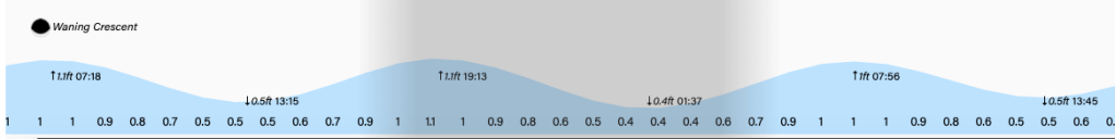
Tides continue to be quite moderate. Have a great Wednesday!
Good morning Bay Islands. On our 7:50 a.m. satellite we can see a storm approaching Utila from the west. We still haven’t gotten any rain recorded at our stations on the east side of Utila, but I wouldn’t be surprised if someone on Utila sees a shower this morning. The rest of us are partly cloudy and dry. The trend continues to be dry and we will have a couple of breezy days.
Our forecast for the next few days will continue to have a chance of showers, especially overnights and early mornings, but those chances are going down each day. We look pretty dry through the weekend.
Wind and Galaxy Wave forecast: We start out the day with 15 mph east winds and seas around 3 feet. Utila is starting out with 10 mph southwest winds. Roatan should calm a bit to 7-12 mph and 2 feet midday but for the most part the next couple of days will be breezy with 15 mph east winds, up to 20 mph overnights, and seas mostly 3 feet. Thursday we will start to calm a bit and Friday into the weekend look quite calm.
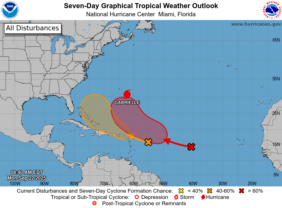
I haven’t said much about the tropics, because there hasn’t been much to say. Hurrican Gabrielle is turning out into the north Atlantic and may even threaten northern Spain this weekend. The red area could develop into a hurricane, but even that should turn back out to sea. And there is NOTHING in the Caribbean to worry about for the next two weeks.
Mitch Cummins is soon to return to the island, but he has left his healthy Roatan Pets production in good hands. Contacts him if you would like more information about locally sourced food specially designed for your furry friend.
Tides continue to be quite moderate. Have a great Tuesday!
Wind and Galaxy Wave forecast: We wake up to 15 mph east winds and 2 foot seas. We should get even calmer midday into the afternoon before getting a bit windier again at sunset. The weekend into Monday should be quite calm with winds 5-10 mph and seas 0-2 feet. As we get into Tuesday into next week we’ll get a bit windier again, but not too bad, with east winds around 15 mph and seas mostly 3 feet.
Don’t forget, 10 percent of proceeds from your purchase at Roatan Pets goes to Roatan Operation Animal Rescue to help the needy critters (and there are many) on our island.
Tides continue on the high side. Have a great Friday!