Good morning Bay Islands. Our photo of the day comes from Daun Weiss, who captured this midmorning shower yesterday, good for .05 of an inch for Punta Blanca and Diamond Rock. We will see more morning rain chances, especially tomorrow through Tuesday.
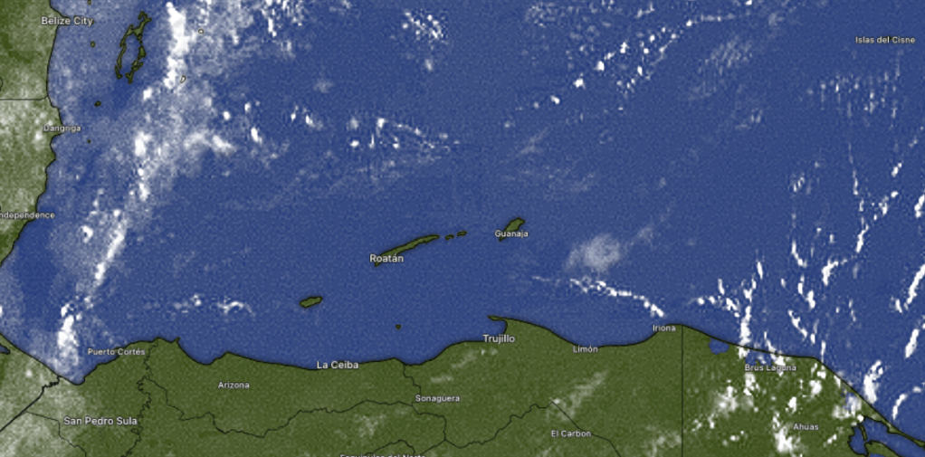
We see a few popcorn clouds on 7:30 a.m. satellite and a couple of locations got a small shower this morning. We’ll be mostly sunny today, but we will continue to see morning popcorn showers the next three days. Not all of us will get one, but some of us will get a quick downpour. Other than that we will be mostly sunny and winds will start to pick up a little. This morning we are at 10 mph east winds and most of us have 1-2 foot seas, though with wave action coming from the northeast, Camp Bay is probably more like 2-3 feet. Winds will continue from the east 10 mph and 2 foot seas days and 15 mph and 3 foot seas evenings and overnights. Have a great weekend!
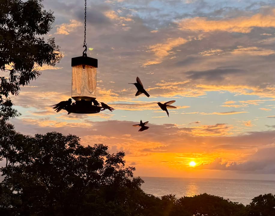
Good morning Bay Islands. Our photo of the day comes from Becky Garver Rance and shows our delightful island hummers at sunset at Turtle Beach.
Our weather continues to be delightful with almost flat calm conditions, very unusual for April. Will that continue?
On satellite at 7 a.m. we can see some clouds moving in on Utila from the north. Radar shows a few showers in there, but mostly to the west of Utila, but it isn’t impossible for Utila to get a quick shower and West Bay should see a few more clouds, but most of the day should be mostly sunny and dry. We will remain calm today with a southwest breeze at 5 mph turning to the north at 10 mph by evening and seas 0-1 foot. We get slightly breezier tomorrow with a daytime southeast wind at 10 mph and seas 1-2 feet and overnight wind at 15 mph. Those winds will be the same through the weekend. Our rain chances go up a bit this weekend, but rain totals shouldn’t be high.
On satellite at 7 a.m. we can see some clouds moving in on Utila from the north. Radar shows a few showers in there, but mostly to the west of Utila, but it isn’t impossible for Utila to get a quick shower and West Bay should see a few more clouds, but most of the day should be mostly sunny and dry. We will remain calm today with a southwest breeze at 5 mph turning to the north at 10 mph by evening and seas 0-1 foot. We get slightly breezier tomorrow with a daytime southeast wind at 10 mph and seas 1-2 feet and overnight wind at 15 mph. Those winds will be the same through the weekend. Our rain chances go up a bit this weekend, but rain totals shouldn’t be high.
Recently purchased a home or building in Roatan? Jungle Water offers interior design & decorating services, remodel work, custom locally-made furniture, trade furniture imported from US stores at great prices, and a home store full of beautiful rugs, lamps and other decorative items. Visit us in Coral Stone Plaza, M-F, 10am-5pm. WhatsApp: 9752-9940
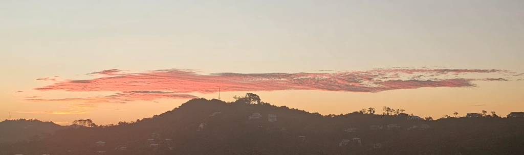
Good morning Bay Islands. Our photo of the day comes from Cesar Gonzalez Sr., and shows the hills midland east of Pristine Bay. We have gorgeous weather today and tomorrow. If you have a chance, get out on the seas. Once those trade winds start back late this week, you won’t get seas this calm for awhile.
We have clear skies overhead with not many popcorn clouds out there. Rain chances are really close to none through Friday. The big story is the wind, which is registering 2-4 knots, or less than 5 mph at the airport, almost dead calm. That means great days on the seas, but it also makes our highs in the mid-80s feel pretty hot. Our winds will pick up a little Thursday and Friday evenings, though the daytimes will still be pretty calm. The trade winds return this weekend into early next week.
Congratulations to Becky Welter, the winner of the March photo of the month contest and an excursion with Jolly Roger Roatan on a regular cruise day.
Many thanks to the Quiggs over at Jolly Roger Roatan for sponsoring the contest. Whichever way the wind is blowing, they always know where to find a calm place on the reef for the best snorkeling around.
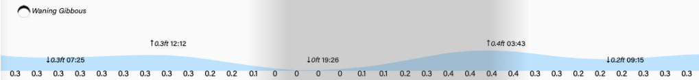
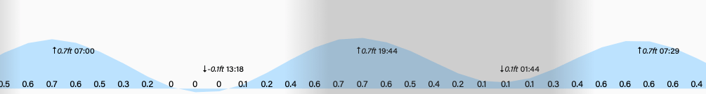
Not only is the weather mild, the tides are mild as well. Have a great Tuesday!
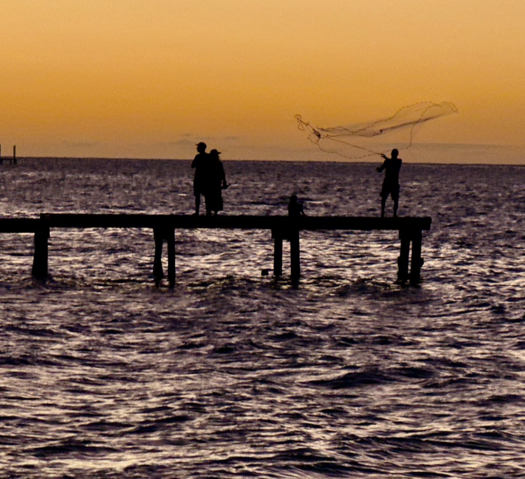
Good morning Bay Islands. Our photo of the day comes from Dalton McCoole and shows net fishing near Camp Bay Beach. Our skies are mostly clear and the main story is going to be calmer winds, starting today around 10 mph and turning to the northeast with 2 foot seas and getting even calmer tomorrow and Wednesday at about 5 mph and 1 foot seas with very little chance of any rain. Winds turn back to the east starting Thursday into the weekend, but even then, it won’t be too bad, with 10-15 mph east winds. Have a great week!
Explore Roatan real estate with the island’s top experts at Roatan Life Real Estate. Serving clients since 2001, we offer personalized guidance in buying and selling properties. Trust our dedicated team for unparalleled local knowledge. Start your journey at http://www.roatanlife.com
We record 4.04 inches from Sandy Bay for the month of March, and that was about average across the islands, though there was a wide range of totals, with a few locations only getting about an inch and a half, and a few others getting over 5 inches. Overall it’s been a wet start to dry season and a few of us have already gotten half an inch in April, the driest month of them all with an average of 1.5 inches. Our forecast for the first half of April is fairly dry, but there are some morning rain chances, so I feel confident that we will surpass our April average rainfall.
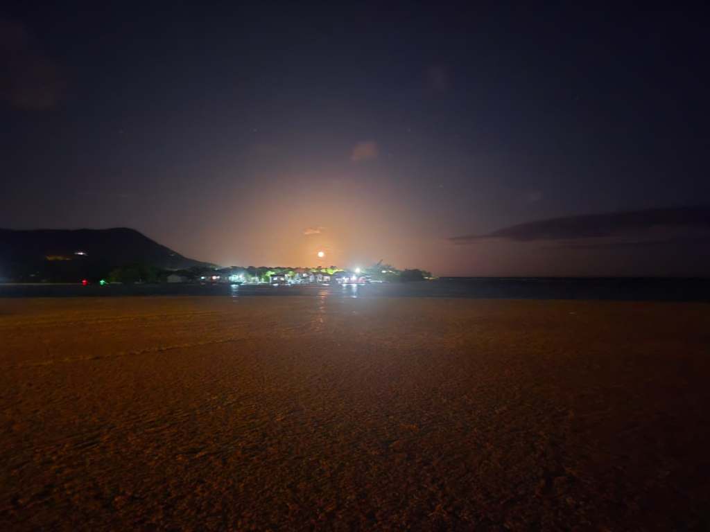
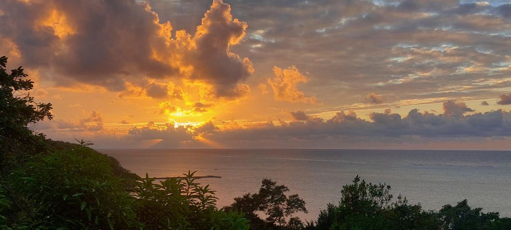
Good morning Bay Islands. Our photo of the day comes from Troy Standish and shows our full moon over orange seaweed at Fiddler’s Bight. Our skies are clear and sunny this morning with an east wind at 15 mph bringing Southside seas of 4 feet.
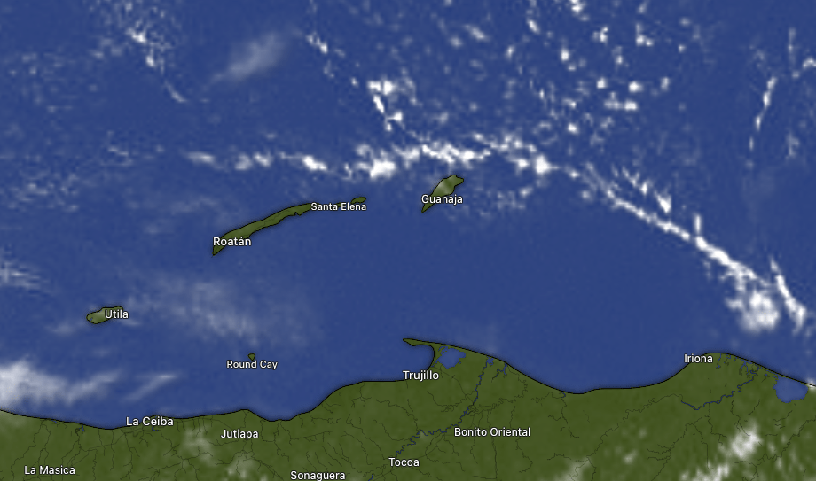
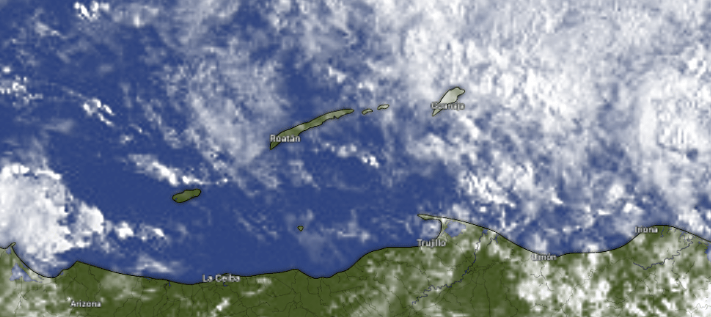
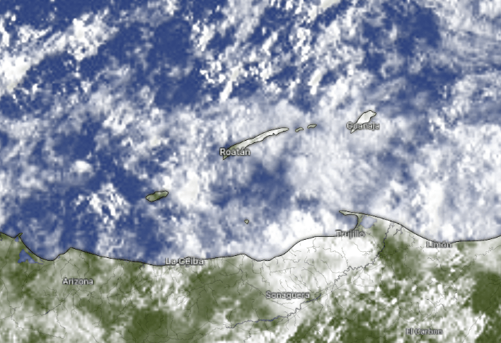
Most of us have clear skies at 7:30 a.m. The clouds to the southeast of Guanaja are actually moving east away from us. We should remain mostly sunny through the weekend with winds similar to what they are now from the east. Winds calm considerably Monday into the first part of next week with seas calming to 1-2 feet. That should help with the kelp.
Explore Roatan real estate with the island’s top experts at Roatan Life Real Estate. Serving clients since 2001, we offer personalized guidance in buying and selling properties. Trust our dedicated team for unparalleled local knowledge. Start your journey at www.roatanlife.com
Low tide is 3:20 p.m. Today is a great day to meditate on what Jesus did for you on this day 1993 years ago! Have a great Friday!
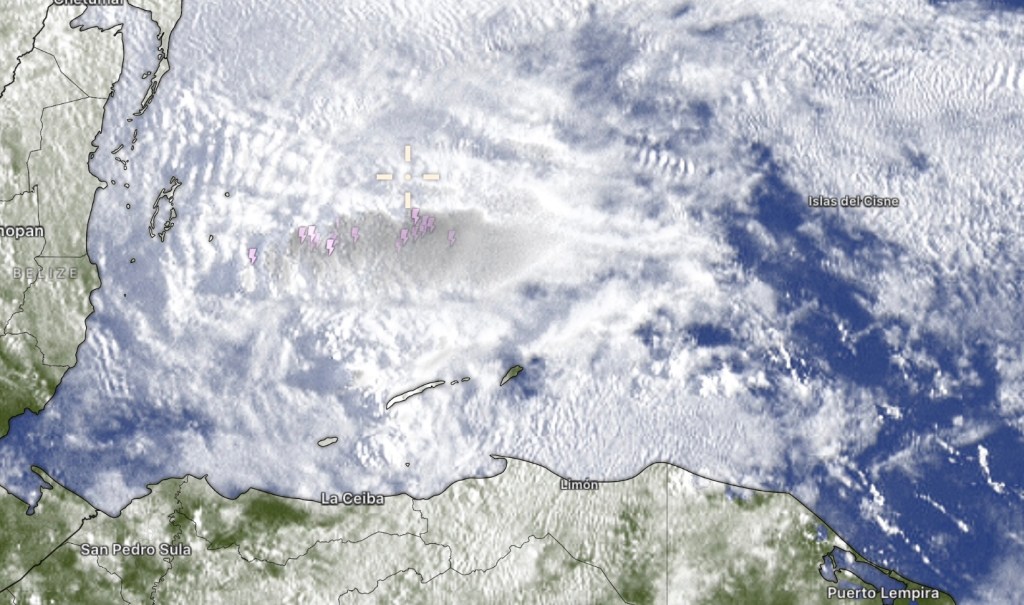
At 6:45 a.m. we see quite a few clouds. The heaviest shower is to our north with some thunder. Fortunately the worst of it is moving away from us. Rain and clouds should decrease as the day goes on, but we will still have a shower here or there today. Rain chances increase again tonight. There will be another chance of morning showers tomorrow, but the weekend looks drier and sunnier.
Screenshot
Wind and wave forecast: We start the day with southeast winds 10 mph and seas 3 feet. Winds should turn more easterly as the day goes on 10-15 mph and seas remain 3 feet. Tonight winds pick up to 15-20 mph and seas 4 feet. These conditions will last through the weekend, with calmer winds early next week.
Wind and wave forecast: We start the day with southeast winds 10 mph and seas 3 feet. Winds should turn more easterly as the day goes on 10-15 mph and seas remain 3 feet. Tonight winds pick up to 15-20 mph and seas 4 feet. These conditions will last through the weekend, with calmer winds early next week.
Good morning and welcome to April! Our photo of the day comes from Angela Smith in Sandy Bay! We are bright and sunny today with sargassum on the south side. I haven’t found a good sargassum monitoring page. If you know of one please send it to me. We will be sunny and dry today with a better chance of rain tomorrow especially in the morning.
At 7:30 a.m. we have some popcorn clouds to our northeast, but most of us have clear skies overhead. Today will be mostly sunny with east winds around 15 mph and seas 3 feet. We will keep those winds and seas the rest of the week, but we will have a better chance of showers tonight into tomorrow morning and we can’t even rule out an afternoon shower tomorrow. After that we should get drier again. We are fortunate to have had these late season rains, because April is typically the month for fires and smoke from the mainland, so let’s hope we keep showers around.
Many thanks to the Jolly Roger Roatan for sponsoring our photo contest. We will be putting up the March vote soon, but we will also be taking a break from the contest. Please continue sending us your photos and we will feature them daily, but we won’t have a monthly contest for awhile. Jolly Roger Roatan will continue offering the best excursions with guaranteed fun!
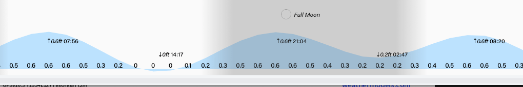
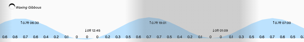
Low tide will be 2:20 p.m. and we will be getting to full moon tomorrow, the most important day of the year! Have a great Wednesday!
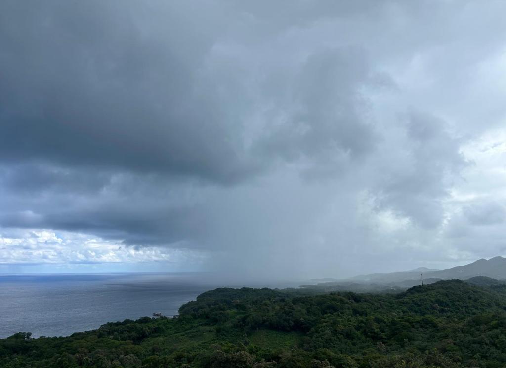
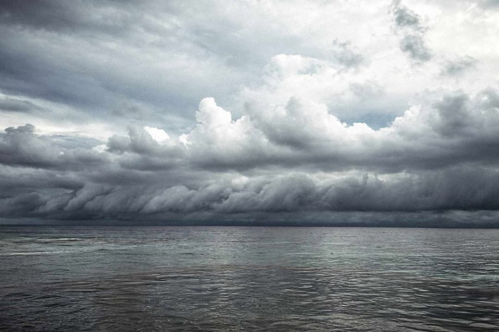
Good morning Bay Islands. Our photo of the day shows rain clouds closing in on Utila from Brad Ryon. It is appropriate, because we have one more day of scattered showers throughout the day. Starting tomorrow we should go back to just overnight and early morning showers.
At 8 a.m. we see quite a bit of clouds to the east and Guanaja has picked up a third of an inch and Camp Bay picked up half an inch just before daybreak. As these clouds move to the west, we should see partly cloudy skies and chances of rain showers here and there, though it should be a washout. After today, rain chances will drop to mostly just early mornings.
Winds will be light today from the east 5-10 mph and seas 2 feet. Starting tomorrow we get more typical trade winds, 10-15 mph and seas 2-3 feet Southside daytimes and 15-20 mph and 3-4 feet south side nighttimes.
Recently purchased a home or building in Roatan? Jungle Water offers interior design & decorating services, remodel work, custom locally-made furniture, trade furniture imported from US stores at great prices, and a home store full of beautiful rugs, lamps and other decorative items. Visit us in Coral Stone Plaza, M-F, 10am-5pm. WhatsApp: 9752-9940
Low tides are 1:30 p.m. and a.m. Have a great week and be careful out there!
Good morning Bay Islands. Our photo of the day comes from Joe Byrne, a truly beautiful sunset over Henry’s Cove for this Palm Sunday. We’ve started off quite wet, with most locations getting between an inch and 2 inches overnight and this morning. Rain should decrease midday and afternoon, but there will still be chances for a few showers out there.
We see scattered clouds and showers around at 7:50 a.m. We will have peeks of sunshine amidst the clouds. Tonight and tomorrow morning another good chance of showers. The most important week of the year for Christians lies ahead, and rain chances will be lower in the week ahead, but we will still have morning rain chances. Winds will be fairly calm today and tomorrow with what breeze we have coming from the northeast and seas 1-2 feet. Starting Tuesday we return to more normal trade winds 10-15 mph from the east daytimes and 15-20 mph nighttimes.
As the advertisement says, the steaks at Carniceria Rosita are “jugosas” or “juicy” in English. Rosita’s is closed today, but will be open as normal tomorrow so you can get your Semana Santa cuts.
High tides will be unusually high as we move toward Thursday night’s full moon. Have a great Sunday!