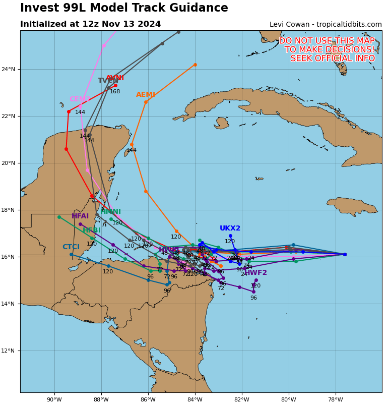
Good morning Bay Islands. I am sorry to say that there is now a very real possibility of the Bay Islands getting a direct hit from a tropical storm or hurricane sometime between Friday and Monday. It isn’t a certainty, but the forecasts are starting to agree that the storm will come our way. You can see that in this map, showing multiple computer forecasts as to the direction the storm will go. The exact location of the storm will make a big difference on any damage to the islands, but the reality is that it is reasonable to make preparations today and tomorrow, because whatever happens, will start to happen on Friday.
Let’s start with this morning’s rain. You can see a small storm brew overnight and come south toward us this morning. As of 7:30 it has given midisland up to 2 inches of rain and about an inch west side. It will probably keep us in clouds this morning with periods of showers. We may see some sun this afternoon. Winds will be from the northwest at 10-15 mph and seas 1-2 feet. Unfortunately tomorrow looks like off and on rain as well as our storm approaches. Depending on what the storm does, we may see winds increase tomorrow afternoon to around 20 mph and seas to 3 feet.
On the broad satellite view we can see a large area of disorganized showers to the east of the Mosquito Coast. All of the models say that this area will organize into a rotating storm, probably sometime tomorrow. After it forms we will have a better idea of exactly where it will go.
This is the wind forecast for the German ICON model. It is a worst case scenario for us. It shows the storm, probably a hurricane, stalling over the weekend, with the eye just to our north. This would cause hurricane strength winds (74 mph) for many or most of us. I don’t need to tell you what that would do to RECO. We would probably be without power for an extended time. It would also bring catastrophic rain of around 2 feet and seas of 15 feet or more.

This is perhaps our best case scenario. The Canadian model has the storm moving inland over the mainland of Honduras. We all know that hurricanes weaken when they move inland, and this scenario would mean probably tropical storm force winds for us over the weekend (39 mph) and about 8 inches of rain.
Be very weather aware. We will know more tomorrow after the storm forms, but there is no harm in being prepared. Whatever happens will start Thursday night into Friday morning and will likely last through Monday morning. Weather next week looks pretty decent Tuesday and Wednesday, but Thursday we may be getting a norther with a stiff north breeze and more rain. Be careful and have a great Wednesday!

Good morning Mike I was wondering if you have any access to the prevailing upper winds the storm is heading our way but it is tending more northerly any chance it will turn before it gets here thanks mike
LikeLike