
Good morning Bay Islands. Our photo of the day comes from Helen Murphy in West Bay showing the Icon of the Seas leaving with the setting of the sun.
We have a small chance of a shower tomorrow and better chances coming Monday into Tuesday.
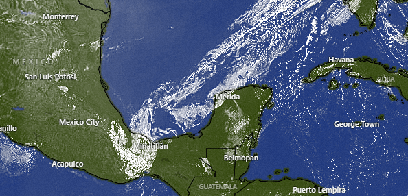
On satellite this morning we see clear skies over us. Clear skies will continue today, but a cold front is coming down from the north. This will give us a few more clouds tomorrow and maybe a 20 percent chance of a shower. Another stronger front is expected Monday into Tuesday which will give us better chances of rain after a dry weekend.
Wind and Galaxy Wave forecast: Winds will be light and variable today and seas 1-2 feet. They will turn back to the east tomorrow at 10 mph and seas 2 feet. Friday into Saturday morning we will be a bit windier at 12-17 mph with Friday seas 2-3 feet and 3-4 feet Saturday morning. Saturday midday and afternoon winds look calmer, but overnight into Sunday morning they get back to 12-17 mph and seas 3 feet. Monday and Tuesday winds turn to the west/northwest with the cold front and there is some disagreement about how strong they will be.
Looking for the juiciest and freshest meat? At Carniceria Rosita they have the best cuts for your favorite roasts, stews and dishes. Stop by and check it out!. 👌🔥
Guaranteed quality and freshness.
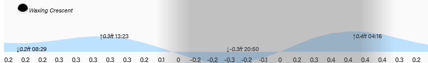
Lowest tide is around 9 p.m. Have a great Wednesday!
