
Good morning Bay Islands. Our photo of the day comes from Joyann Villalta Sanders who has been observing this hummingbird momma raising her young in this nest. Hummingbirds are among my favorite of God’s creations. Humans are OK, but I really like hummingbirds.
Humans and hummingbirds are probably going to have to deal with scattered showers tomorrow.
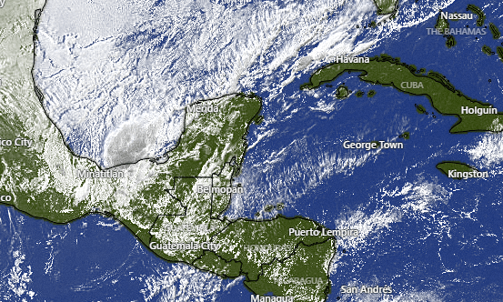
On the broad satellite view we can see the cold front coming down through The Gulf toward us. After a mostly sunny day today we will see increasing clouds tonight into tomorrow. Best chances of rain are tonight into tomorrow morning and tomorrow night into Saturday morning, but we will also have rain chances during the day tomorrow. Rain totals don’t look to be much more than half an inch to an inch for most of us.
Rain chances return for Monday night into Tuesday, though the models are pushing most of that rain to our east.
Wind and Galaxy Wave forecast: Winds this morning are from the east at 15 mph with 3 foot seas mostly south side. Winds this evening will turn more to the northeast at 15 mph, which should give us a bit more surf on the north side. We’ll keep those northeast winds through tomorrow night. Sunday we see much more calm winds and seas and those will continue into next week.

Thursday is a good time to start thinking about that weekend trip you’ve been promising yourself to see Guanaja for the first time. You can leave at noon Friday and return Sunday morning and have a quick two-night vacation on the island that retains an old-Bay Islands feel.
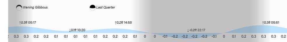
Tides remain low. Have a great Thursday!
