
Good morning Bay Islands. Our photo of the day comes from Jeff Bodin in Carib Bight and shows Sara receding over the mainland this past weekend. We have another storm coming, but this time it is not a tropical storm but a norther. For you tourists reading this, that is what locals call a cold front. It brings cool temperatures, gusty north winds and rain showers.
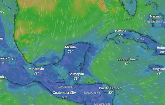
This wind map shows the leading edge of the norther stretching from Tampa through the Yucatan. Today we will have west winds at 15 mph and seas around 3 feet, calming to 2 feet this evening.
Tomorrow morning we will start to see the winds turn to the north and increase through the day. Tomorrow we will have off-and-on showers through the day, tomorrow night and into Friday morning. Rainfall totals will be nothing like Sara. We should get 1-2 inches out of this norther. Seas will be 5-6 feet on the northside tomorrow evening through Friday morning.
The weekend north winds will calm to 5-10 mph and seas to 2-3 feet and light showers here or there and much cooler temperatures with around 70 for lows and 80 for highs.
We have another norther, perhaps not as windy but may a little rainier, for Tuesday and Wednesday of next week.
Even when the forecast is a little concerning, you can trust the folks at Jolly Roger Roatan to give you the best time possible around the island and get you back on your boat safely. Request their excursions from your cruise’s activities director.

Low tide is 8 p.m. Have a great Wednesday!
