
Good morning Bay Islands. Our photo of the day comes from Regina Alpaugh and shows a full moon over Tita’s Pink Seahorse in West End. Don’t forget the most-liked photos will compete Nov. 1 for $50 in Café Rubio coffee. We are moving back into full moon phase, but we might not get to see much of it with all the clouds we will be having.

t’s start with our close up satellite. We have a few scattered showers at 7 a.m., especially between Sandy Bay and Pristine Bay. We will continue to see a few showers around, but also some blue sky today and tomorrow. Winds this morning are from the west at 5-10 mph and seas around 2 feet. Winds and seas should be fairly calm today and tomorrow.
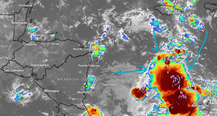
Now let’s back up and look at our tropical wave, right now close to the west coast of South America. We should start seeing rain increase Thursday night and we will have LOTS of rain through Sunday morning. I think flooding is the main threat from this system. On the low end the Euro is forecasting 4-5 inches and on the high end the GFS and ICON are forecasting 8-10 inches. The GFS is also giving us winds from the east 20-30 mph, especially Saturday. The Euro says only 10-15 mph.
I hate to say it, but after this passes, next week will continue rainy, with more cold fronts pushing down from North America.

Explore Roatan real estate with the island’s top experts at Roatan Life Real Estate. Serving clients since 2001, we offer personalized guidance in buying and selling properties. Trust our dedicated team for unparalleled local knowledge. Start your journey at www.roatanlife.com.
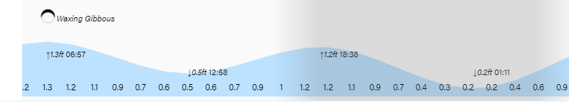
Tides continue to be quite high. Have a great Tuesday!
