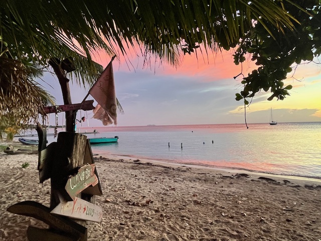
Our photo of the day from John DeBusi in West End puts us in mind of the old saying “Red sky in morning, sailor take warning; Red sky at night, sailor’s delight.” That saying does seem to have some truth to it. We’ll be watching for rainy weather, especially as we get into Monday and Tuesday.
We had a storm off to our east the brought a little rain to the east side, with most folks getting about a tenth of an inch. There was also a shower around 9 p.m. last night in many locations. This storm seems to be weakening, so we will go with a 20 percent chance of a shower, especially this morning. Over the next several days we will see our nighttime and early morning rain coverage increasing as the tropical system start to wind up. Peak rain looks like it will be Monday, Monday night and Tuesday.
This morning we have 5 mph east winds and seas around 2 feet. Winds and seas should stay pretty calm through the weekend. As storms begin to increase, watch for squalls that can cause temporarily rough seas.

The GFS shows this potential strom winding up right over our heads, so watch out for scattered thunderstorms, especially Sunday night through Tuesday. It should move out to our west midweek next week. At the end of this loop you can see a storm forecast for us in two weeks, but that is a long way off and these forecasts aren’t very accurate that far out.

Explore Roatan real estate with the island’s top experts at Roatan Life Real Estate. Serving clients since 2001, we offer personalized guidance in buying and selling properties. Trust our dedicated team for unparalleled local knowledge. Start your journey at www.roatanlife.com
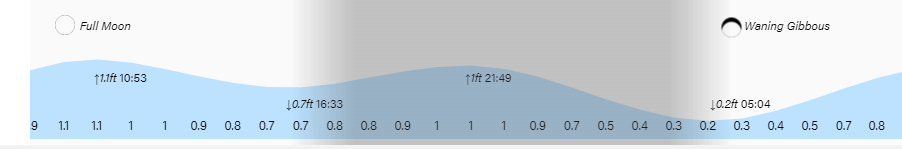
High tide will be 11 a.m. as we continue to have quite high tides. Have a great Friday!
