
Good morning Bay Islands. Our Photo of the Day comes from Cathy Chestnut, who found a halo around the sun on a trip to Utila. These halos are not signs of sainthood, they are caused by ice crystals high up in the atmosphere. If you would like to submit a photo, send it to bookmybio@gmail.com with name and location.
We had another round of thunderstorms pass through early this morning. There is reason to believe the next few night may be a little quieter and the weekend a little rainier.
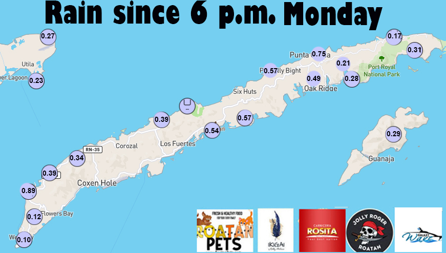
Here is the rainfall from overnight.
The satellite from last night starts just after midnight and shows the storms crossing over our islands. You can see that at the end, around 7 a.m., there are a few popcorn clouds forming east of Guanaja that will give us a very small chance of a morning shower. After that we should be partly cloudy most of the day. Moisture high up in the atmosphere will be a little less than we have had recently, so today through Thursday we will say a 40 percent chance of rain at night and early morning and 20 percent middays and afternoons. Friday into the weekend rain chances go up again.
Wind and Galaxy Wave forecast: We wake up to east winds 10 mph and seas around 2 feet. Winds this afternoon will increase to 15 mph and seas to 2-3 feet. Tomorrow looks like a fairly calm day, with east winds 5-10 mph and seas closer to 1 foot. Starting Thursday our winds should get a little higher, around 12-17 mph and seas 2-3 feet.
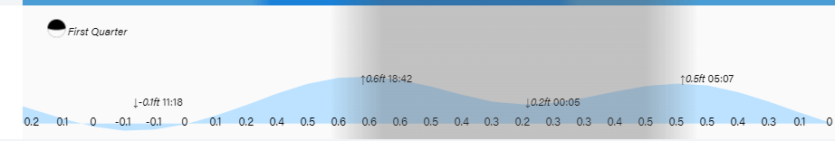
Low tide is 11:20 a.m. Have a great Tuesday!
